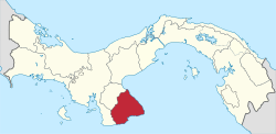
Los Santos Province
Coordinates: 7°56′N 80°25′W / 7.933°N 80.417°W
| Los Santos Province Provincia de Los Santos | ||
|---|---|---|
| Province | ||
 | ||
| ||
 | ||
| Country | Panama | |
| Capital city | Las Tablas | |
| Government | ||
| • Governor | Yina Smith de Barrios | |
| Area | ||
| • Total | 3,809.4 km2 (1,470.8 sq mi) | |
| Population (2010 census) | ||
| • Total | 89,592 | |
| • Density | 24/km2 (61/sq mi) | |
| Demonym(s) | Santeño (a)[1] | |
| Time zone | Eastern Time (UTC-5) | |
| ISO 3166 code | PA-7 | |

Los Santos (Spanish pronunciation: [los ˈsantos]) is a province of Panama, reaching from the La Villa river in the North to the Pacific Ocean in the south and east. It is part of Azuero Peninsula, bounded by province of Herrera to the north and northeast and Mariato district in Veraguas to the West. The City of Las Tablas is the capital and most populous city; seven other districts of Los Santos, Guararé, Las Tablas, Macaracas, Pedasi, Pocrí and Tonosí are under the jurisdiction of Los Santos Province Governorate. Los Santos' area is 3 809.4 km ², and its population is about 89,592 inhabitants.
It shares its name with the fictional version of Los Angeles in the hit game, Grand Theft Auto V. Los Santos means "The Saints", as opposed to Los Angeles, which means "The Angels".
In this region are the oldest human settlements in the Isthmus of Panama. It was part of the cultural region of Gran Cocle where one of the first ceramic styles of the Americas developed.[2] The first Europeans to explore Los Santos were the Spanish in 1515 under the command of Gonzalo de Badajoz. Upon the arrival of Europeans the area was ruled by the cacique Antataura or Cutara, and was known as the Land of Mr. Paris or Parita from Ngäbere Bari-ta meaning Confederation of Peoples, having under his control six other Indian chiefdoms: Guararí, Quemá, Chiracoitia, Huere, Guanata and Usagaña. The only province that was not under his dominion was Escoria. Gaspar de Espinosa succeeded in conquering and annexing Pariba to the Spanish Empire in 1516, decimating nearly all of the native population.
Geographically, Los Santos is located in the 'Arco Seco', name given to the strip of land between the Gulf of Panama and the Central Mountain range which includes areas of the provinces of Cocle, Herrera and Veraguas in the south of the Isthmus of Panama.[3] Its climate is mainly a tropical savanna climate with moderate temperatures, strongly influenced by the winds of the Pacific Ocean crashing against the mountains, and the Humboldt Current. The average annual rainfall is 1,200 mm, allowing the growth of either dry or humid rainforest. Its highest point is located at the peak of Cerro Hoya with 1559 metres. Other major peaks are Cambutal hill (1400 metres) and Mount The Ñopos (1068 metres).
The modern province of Los Santos, was created in January 1945 replacing the defunct province of Azuero according to Cabinet Decree No. 13, leaving its territorial regime regulated by the second chapter of the Law 58 of July 29, 1998, losing the Territory of Quebro in this process.
Although Los Santos closely shares its political and social history with the rest of Panama, and the vast majority of the population speaks Spanish, the province has retained a distinct cultural identity. Los Santos' culture is the result of the passage of different peoples and civilizations that, over time, have shaped a particular cultural identity. These people, some very different from each other, have been slowly leaving an imprint seated among the inhabitants. It is one of the last regions in Panama where Spanish voseo is the standard form for use.
Toponymy
As is common in most of Panama, the province took its name from its ancient capital, La Villa de Los Santos. Founded on November 1569, All Saints' Day, takes its name from this Catholic celebration. The Day of All Saints is a Christian tradition instituted in honor of All Saints, known and unknown, as Pope Urban IV, to compensate for any lack of the feasts of the saints during the year by the faithful. It has roots in the Celtic festival of Samhain or Samain. The Saints (<Latin sanctus, -i; ['chosen by God']) are distinguished men and women in the various religious traditions for their alleged special relationship with the gods.
Symbols
.svg.png)
The official flag of Los Santos consists of three equal horizontal stripes, coloured red, blue and yellow respectively. It is based on the chromatic composition created in 1801 by Francisco Miranda, precursor of Latin American independence, who flew the pavilion in Jacmel, Haiti for the first time.[4] As to the meaning of the colors, the most accepted hypothesis states that it is based on the primary colors as perceived by the iris. A second theory states that it is based on the colors of the primitive coat of arms of Christopher Columbus;[5] and lastly, a third theory says that it is based on the colors of the uniforms of the Burgerwache in Hamburg. The first theory is based in a letter, where Miranda describes a conversation with Johann Wolfgang von Goethe about its Theory of colours at a party hosted in the city of Weimar in 1785.[6] The santeños Patriots took this model to represent Los Santos in 1821 in the battle to gain independence from Spain. With the creation of the province of Azuero on April 4, 1850 this flag became the official flag of the province and subsequently, became the official flag of Los Santos province, heir of the former Azuero province.
Climate
Located in the Tropics, Los Santos has a rainy season which stretches from May to November, and a dry season extending from late November to early May. According to Köppen climate classification, the province of Los Santos has a tropical savanna climate Awi. The southeast of Los Santos is usually warmer and drier than the west, owing to the influence of Pacific ocean currents and altitude. Rainfall varies widely across Los Santos. The eastern highlands of Los Santos are the wettest, with annual rainfall in a few places like Cerro Hoya and Canajagua exceeding 4,000 mm. In comparison, much of lowland Los Santos receives less than 1200 mm annually. Temperatures range between 23 °C and 32 °C on the coast, with a minimum of 14 °C in the mountain region. These variations are caused by the mountains of Azuero range and rainfall that occur over very short distances.
| Climate data for Los Santos, Panama (1984–2014) data | |||||||||||||
|---|---|---|---|---|---|---|---|---|---|---|---|---|---|
| Month | Jan | Feb | Mar | Apr | May | Jun | Jul | Aug | Sep | Oct | Nov | Dec | Year |
| Average high °C (°F) | 33.6 (92.5) |
34.1 (93.4) |
34.8 (94.6) |
35.4 (95.7) |
35.4 (95.7) |
34.4 (93.9) |
34.0 (93.2) |
34.3 (93.7) |
34.0 (93.2) |
33.8 (92.8) |
33.5 (92.3) |
35.4 (95.7) |
35.4 (95.7) |
| Average low °C (°F) | 18.8 (65.8) |
19.2 (66.6) |
19.9 (67.8) |
21.0 (69.8) |
22.0 (71.6) |
21.7 (71.1) |
21.1 (70) |
21.2 (70.2) |
21.0 (69.8) |
21.2 (70.2) |
20.5 (68.9) |
19.7 (67.5) |
19.2 (66.6) |
| Average precipitation mm (inches) | 12.1 (0.476) |
0.7 (0.028) |
3.7 (0.146) |
21.1 (0.831) |
111.2 (4.378) |
137.3 (5.406) |
96.6 (3.803) |
123.2 (4.85) |
161.6 (6.362) |
224.8 (8.85) |
126.0 (4.961) |
46.6 (1.835) |
1,053.7 (41.484) |
| Average rainy days | 1.1 | 0.2 | 0.3 | 1.8 | 7.8 | 11.5 | 9 | 10.5 | 12.8 | 14.4 | 10.3 | 4.2 | 83.9 |
| Source #1: [7] | |||||||||||||
| Source #2: | |||||||||||||
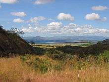
Geography and natural history
The mainland of Los Santos comprises most of the southern portion of the Azuero Peninsula, which lies in the south of Panama and two main islands, Iguana Island and Cañas Island, and the small Isla Frailes del Norte and Isla Frailes del Sur. The total area is 3,809.4 km2 with 214 km2 of coast shores, comparable to the size of Cape Verde. Los Santos's border with Herrera to the north, runs along La Villa river, which exerts a natural border, although both sides of the river show the same landscape. The Pacific Ocean borders the south and east with a large area of coastline, giving it a major maritime landscape. Finally, Mariato District west border is characterized by its mountainous natural shape, separating the Gulf of Montijo in Veraguas from the valleys of Tonosi.
Relief
Los Santos is in the Azuero Peninsula in the Isthmus of Panama. The major geographical features of the province are determined by three morphostructural regions which are characterized by its elevations. It is clearly divided into three zones: the mountainous area dominated by the Azuero mountain ranges: Western Azuero range and Eastern Azuero range, known locally as sierra de Azuero. The mountains are an extension of the Cordillera Central extending south until its extinction in coastal Búcaro and Cañas. There are few valleys, prominent among them are the Tonosí and Rico valley. A transitional zone of low hills and clustered mainly in the central southern part of the province hills. A third area in low-lying coastal regions coastal plains and sedimentary basins, where the hilly reliefs that are part of the foothills of the mountains predominate.
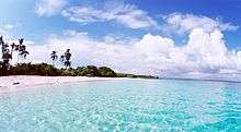
The coastline of Los Santos is characterized by an overwhelming predominance of beaches and coastal lowlands with the presence of some cliffs especially in the southern part of the Sierra de Azuero in Tonosí. Mangroves and small dune formations are the most characteristic element of the coastal relief. The beaches are dissipative, fine golden sand on the north and darke volcanic in the south, with annual variations in the coastline that can be labeled due to winter storms.
Flora and Fauna

Los Santos’ wildlife is typical of Panama with several distinctions. The province is home to 62 bird species. Because of its long coastline Los Santos hosts a variety of seabirds. The coasts and surrounding islands are home to colonies of egrets, herons and cormorants. It is also, the largest nesting site in Panama for the frigatebird, with a population of more than 5000 in Isla Iguana Wildlife Refuge.
Azuero's monkeys
Los Santos is home to five of the seven monkeys species living in Panama, some of them critically endangered: Saguinus geoffroyi, Azuero Howler Monkey, Azuero Spider Monkey, Western Capuchin Monkey and Aloutta palliata.
National Parks in Los Santos
Los Santos has 6 national parks: La Tronosa, Tonosí, Cerro Hoya, Cerro Canajagua, Santa Ana and El Colmón. It has five wildlife refuges. These areas include El Peñón de la Honda, Isla Cañas, Isla Iguana, Pablo Arturo Barrios and La Marinera. The coastline of La Enea and El Espinal corregimiento and the basin of Cacao and Mensabé river are also protected.
Demographics
At the 2010 Panamanian census, Los Santos had 89,592 residents and 29,363 householdsliving within the administrative boundaries. Of those households, 17,352 were married couples living together, 22,679 were co-habiting couples and 10,947 were lone parents or widowers.
The 2010 census showed that 5,252 residents or 6.6% of the population is illiterate. The ethnicity of Los Santos according to data of the 2010 census was composed mainly by descendants of Spanish and Mestizos, composing 98% of the residents. Minority groups were composed of 1,276 African and 656 amerindian. The amerindian population constituted only 0,7% of the population, of whom 36% were Kuna, 35% Ngäbe, 17% Buglé and 12% others groups such as Teribe/Naso, Emberá, Bribri and Wounaan.[8]
Religion is not recorded in the census, but the majority is Christian, with Catholic and a significant proportion of Protestant being the most important groups.
Government
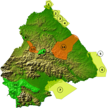
The province is divided in 7 districts:

- Guararé District. Corregimientos include Guararé (capital), El Espinal, El Macano, Guararé Arriba, La Enea, La Pasera, Las Trancas, Llano Abajo, El Hato and Perales.
- Las Tablas District. Corregimientos include Las Tablas (capital), Bajo Corral, Bayano, El Carate, El Cocal, El Manantial, El Muñoz, El Pedregoso, La Laja, La Miel, La Palma, La Tiza, Las Palmitas, Las Tablas Abajo, Nuario, Palmira, Peña Blanca, Río Hondo, San José, San Miguel, Santo Domingo, El Sesteadero, Valle Rico and Vallerriquito.
- Los Santos District. Corregimientos include La Villa de los Santos (capital), El Guásimo, La Colorada, La Espigadilla, Las Cruces, Las Guabas, Los Angeles, Los Olivos, Llano Largo, Sabanagrande, Santa Ana, Tres Quebrada, Villa Lourdes and Agua Buena.
- Macaracas District. Corregimientos include Macaracas (capital), Bahía Honda, Bajos de Guera, Corozal, Chupa, El Cedro, Espino Amarillo, La Mesa, Llano de Piedra, Las Palmas and Mogollón.
- Pedasí District. Corregimientos include Pedasí (capital), Los Asientos, Mariabé, Purio and Oria Arriba.
- Pocrí District. Corregimientos include Pocrí (capital), El Cañafístulo, Lajamina, Paraíso and Paritilla.
- Tonosí District. Corregimientos include Tonosí (capital), Altos de Guera, Cañas, El Bebedero, El Cacao, El Cortezo, Flores, Guánico, La Tronosa, Cambutal and Isla de Cañas.
History
In 1850, the province of Azuero was created in honor of Vicente de Azuero y Plata. In 1855, with the establishment of the "Estado Federal de Panamá", the province was divided into the departments of Los Santos and Herrera. After the union with Colombia, and later with Panama becoming a sovereign state, Los Santos underwent many political and administrative changes. In 1941, with the presidency of Ricardo A. de la Guardia (1941–1945), Los Santos and Herrera were established as one province, named Los Santos. By the Decreto de Gabinete N° 13 of January 8, 1945; Herrera and Los Santos became two different provinces.
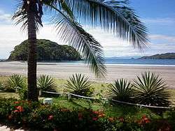
Tourism
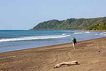
There are many well-renowned beaches, as found in Venado, Achotines, and Guararé. There are also beaches on the island, Isla Iguana, known for its blue water and white sand. The island is 25 minutes by boat from Pedasí. There are also parks here, such as the national park Cerro Hoya. There are also museums like the: Museum of Nationality (Museo de la Nacionalidad), the Museum Belisario Porras and the Museum Manuel F. Zarate. There is also an arqueological site here called the Sitio Arqueologico Cerro Juan Diaz. There is also the Church of San Antonio and the Church of Santa Librada (made on March 1872). In 1958, a fire burned the Santa Librada's roof.
Culture
Las Tablas is the capital of the province, one of its biggest attractions is the church of Santa Librada, considered a national monument.
The city lives all its splendor during the Carnival celebration that lasts 4 days and 5 nights, being the headquarters city of Las Tablas Best Carnival of the republic, where one of the main attractions of the carnival in Las Tablas, are famous or culecos mojadera, which is sprayed with water (clean and purified) to the participants of this activity from sisternas cars (especially pre-sterilized for this activity) located throughout the park and surrounding streets are where the carnival, while can admire the tour of the queens of both streets, street up and down the street on spectacular floats, and suitable for this activity packed day, with the notes of the contagious and famous and well known murgas of Panama (which also have its epicenter in the town of Las Tablas, where the best murgas the country), do jumping and dancing for joy to young and old alike, unable to contain her joy and excitement following the queen with the most sympathetic all day without stopping or until the forces accompanying the activity takes place during four days of carnival, another attraction of this carnival is wasteful luxury and splendor of the costumes shown in the queens and their ladies, and the designs and finishes epectaculares floats of both daytime (from culecos or mojaderas) and evening, reaching its greatest splendor Carnival on Monday, his grace and charm of women represented in their Tableña and queens in ladies of his court to make the carnival Tableño one of the best and most famous carnavals the world.
Another well-known celebration is Corpus Christi, a religious holiday which dates its beginnings to the colonial era. It commemorates the institution of the Eucharist in the mix with pagan festivals represented by different dance, which today form part of the folklore of the region, this activity takes place in the City of La Villa de Los Santos.
Los Santos is the place to see the beautiful hand-woven Polleras, the typical costume of Panama. Here you will find artisans who make masks of the famous "Diablicos".
Notable People
- Ramiro Mendoza, former Major League Baseball player
References
- ↑ http://buscon.rae.es/drae/srv/search?val=sante%F1o
- ↑ http://biblioteca.ucm.es/tesis/ghi/ucm-t27302.pdf
- ↑ http://www.pnuma.org/deat1/pdf/GEOPanama2004.pdf
- ↑ http://web.archive.org/web/20060826092406/http://www.bnv.bib.ve/evohistbandvzla.htm
- ↑ http://www.banrepcultural.org/node/32622
- ↑ http://www.monografias.com/trabajos21/bandera-del-mundo/bandera-del-mundo.shtml
- ↑ Climate averages in the last 30 years. Met Office (19 November 2008). Retrieved on 17 July 2013.
- ↑ https://www.contraloria.gob.pa/inec/publicaciones/Publicaciones.aspx?ID_SUBCATEGORIA=59&ID_PUBLICACION=360&ID_IDIOMA=1&ID_CATEGORIA=13
Capital: Las Tablas | ||
| Guararé District | | |
| Las Tablas District | ||
| Los Santos District | ||
| Macaracas District | ||
| Pedasí District | ||
| Pocrí District | ||
| Tonosí District | ||
| Provinces | ||
|---|---|---|
Corregimiento-level Comarcas indígenas | ||