Channel Islands Harbor
| Channel Islands Harbor | |
|---|---|
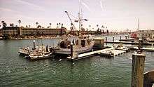 Scene from commercial fishing boat unloading pier facing southeast with hotel in background | |
| Location | |
| Country | United States |
| Location | Oxnard, California |
| Coordinates | 34°10′12″N 119°13′30″W / 34.17°N 119.225°WCoordinates: 34°10′12″N 119°13′30″W / 34.17°N 119.225°W |
| Details | |
| Opened | 1960 |
| Owned by | County of Ventura[1] |
| Type of harbor | Artificial |
| Size of harbor | 166 acres |
| Available berths | 2,150 |
|
Website channelislandsharbor | |
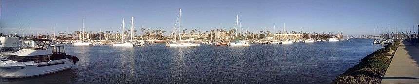
Channel Islands Harbor is a combined shore-protection project[2] and small craft harbor located at the southern end of the Santa Barbara Channel[3] in Oxnard, California. It is the fifth largest harbor for small-craft recreation in the state of California[4] and is a waterfront resort, recreation, and dining marketplace. Recreational activities include diving, boat charters, sea kayaking, sportfishing, and whale watching (gray whales January through early April; blue and humpback whales July to September).
The horse-shoe shaped harbor contains 166 acres (0.67 km2) of water surrounded by 126 acres (0.51 km2) of land[5] and supports more than 2,500 vessels,[6] four yacht clubs, and nine full-service marinas.[7] It is a point of departure for the five Channel Islands, the closest of which is Anacapa Island.[4] The Ventura County Maritime Museum is located within the harbor and offers a regularly rotating exhibit, maritime-themed art, and model ships. Water taxis are available to drop diners and shoppers at various docks within the harbor.[8] Every three years the harbor is host to the Channel Islands Tall Ships Festival which includes between two and five large sailing vessels and draws thousands of visitors.[6]
History
The US Army Corps of Engineers formed the harbor in 1960 by scooping out sand dunes and wetlands and depositing the surplus sand at the nearby beaches of Port Hueneme.[6] The sand trap at the harbor entrance was designed to retain sand that otherwise might be diverted into the ocean due to the impacts of the construction of the Port of Hueneme.[9] The sand was to be regularly dredged and placed on Hueneme Beach which suffers erosion due to the port blocking the littoral drift of sand.[10]
Neighborhood and destinations
The harbor waters connect to the north with Mandalay Bay, a residential 129-unit waterfront development built by a company called Shamrock/ Voss, a joint venture of Shamrock Holdings Inc. of Burbank and Voss Construction Co. Inc. of Oxnard in 1987.[11] The development is arranged in six tracts of single-family homes and townhouses standing on reinforced concrete bulkheads along a series of short navigable canal-like waterways.[12] Between 1950 and 1981 Mandalay Bay was a permitted oil field waste disposal site which caused the release of numerous hazardous chemicals.[13] The records of what was dumped were subsequently lost, resulting in calls for an investigation and millions of dollars in lawsuits from home buyers who were told the area was safe for habitation.[14]
The Channel Islands Boating Center opened in 2013.[15][16]
References
- ↑ Channel Islands Harbor Website "About Us/Harbor Information" Accessed 24 Dec 2013
- ↑ Herron, William J.; Harris, Robert L. (1966) LITTORAL BYPASSING AND BEACH RESTORATION IN THE VICINITY OF FORT HUENEME CALIFORNIA Proceedings of 10th Conference on Coastal Engineering, Tokyo, Japan
- ↑ United States Army Corps of Engineers, South Pacific Division (1973). Water resources development by the U.S. Army Corps of Engineers in California. University of California Libraries. p. 89. ISBN 978-1-125-52499-2.
- 1 2 Travis, William, ed. (2006). Fodor's Southern California (Second ed.). New York: Random House. p. 385. ISBN 978-1-4000-1603-7.
- ↑ Smith, Patricia (1998). "Channel Islands Harbor Master Plan" (PDF). Retrieved 1 May 2011.
- 1 2 3 McKinney, John (2005). California's coastal parks: a day hiker's guide (1st ed.). Berkeley, CA: Wilderness press. p. 78. ISBN 0-89997-388-4.
- ↑ Harris, Elanor; Lichtig, Claudia Harris (2006). Quick escapes Los Angeles: 20 weekend getaways from the metro area (7th ed.). Guilford, CT: Globe Pequot Press. p. 124. ISBN 978-0-7627-4219-6.
- ↑ Marcum, Diana (July 4, 1999). "Water Taxi! Water Taxi!". Los Angeles Times.
- ↑ Meyers, Jeff (November 1, 1990) "An Era of Sail Lies Anchored in Two Harbors : Boating: Ventura County shoreline took on greater appeal with construction of marinas in Ventura and Oxnard." Los Angeles Times
- ↑ (September 8, 2014) "Dredging at Channel Islands Harbor will begin Oct. 1" Ventura County Star
- ↑ Boyd-Barrett, Claudia (Jun 27, 2014) "Oxnard harbor-area residents push for central authority" Ventura County Star
- ↑ "Oxnard Condo Development to Get Start", The Los Angeles Times, Los Angeles, California, p. Section 8 p.14, 29 March 1987
- ↑ Public Meeting Fact Sheet (October 2005) "Cleanup Proposal for North Shore at Mandalay Bay Site—Oxnard, California" State of California Department of Toxic Substances Control. Retrieved 2 August 2014
- ↑ McCartney, Patrick (10 November 1991). "Flynn Calls for Mandalay Bay Investigation : Oxnard: At issue is whether all traces of a landfill and oil-waste dump were removed before the waterfront housing was built". Los Angeles Times.
- ↑ Biasotti, Tony (Apr 3, 2013) "Much-delayed Channel Islands Boating Center opens in Oxnard" Ventura County Star
- ↑ Wilson, Kathleen (July 21, 2016). "County balks at agreement for boating center, saying university operator has fallen short". Ventura County Star. Retrieved 22 July 2016.
| Wikimedia Commons has media related to Ports and harbours in California. |