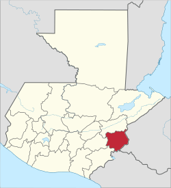
Chiquimula Department
| Chiquimula | |||
|---|---|---|---|
| Department | |||
| |||
 Chiquimula | |||
| Coordinates: 14°47′58″N 89°32′37″W / 14.79944°N 89.54361°WCoordinates: 14°47′58″N 89°32′37″W / 14.79944°N 89.54361°W | |||
| Country |
| ||
| Department | Chiquimula | ||
| Capital | Chiquimula | ||
| Municipalities | 11 | ||
| Government | |||
| • Type | Departmental | ||
| Area | |||
| • Department | 2,376 km2 (917 sq mi) | ||
| Elevation | 424 m (1,391 ft) | ||
| Population (Census 2002)[1][2] | |||
| • Department | 302,485 (Ranked 14th) | ||
| • Urban | 78,631 | ||
| • Ethnicities | Chorti, Ladino | ||
| • Religions | Roman Catholicism, Evangelicalism, Maya | ||
| Time zone | -6 | ||
| ISO 3166 code | GT-CQ | ||
.png)
Chiquimula is a department of Guatemala, in Central America.
Population
As of 1850, the population was an estimated 80,000.[3]
Governance
Municipalities
- Camotán
- Chiquimula
- Concepción Las Minas
- Esquipulas
- Ipala
- Jocotán
- Olopa
- Quezaltepeque
- San Jacinto
- San José La Arada
- San Juan Ermita
Economy
Historically, tobacco was the department's main industry. The area also produced maize, rice, cotton, and beans. Sugar cane was also produced, which was used primarily to make chicha. Cattle, horses and mules were also raised.[3]
References
- ↑ "XI Censo Nacional de Poblacion y VI de Habitación (Censo 2002)". INE. 2002.
- ↑ "Comunidad Lingüística Ch'orti'". Academia de Lenguas Mayas. 2008. Retrieved 2008. Check date values in:
|access-date=(help) - 1 2 Baily, John (1850). Central America; Describing Each of the States of Guatemala, Honduras, Salvador, Nicaragua, and Costa Rica. London: Trelawney Saunders. p. 88.
This article is issued from Wikipedia - version of the 8/18/2016. The text is available under the Creative Commons Attribution/Share Alike but additional terms may apply for the media files.