Jocotán
| Jocotán | |
|---|---|
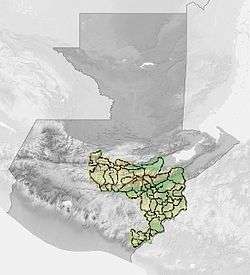
 Jocotán Location in Guatemala | |
| Coordinates: 14°49′0″N 89°23′0″W / 14.81667°N 89.38333°WCoordinates: 14°49′0″N 89°23′0″W / 14.81667°N 89.38333°W | |
| Country |
|
| Department | Guatemala |
| Government | |
| • Mayor (2016-2020) | José Fernando Carrera Franco (Partido Patriota) |
| Area[1] | |
| • Total | 57 sq mi (148 km2) |
| Population (2002) | |
| • Total | 40,903 |
| • Density | 715.8/sq mi (276.37/km2) |
| [2] | |
| Climate | Aw |
Jocotán is a municipality in the Chiquimula department of Guatemala.[1]
This town is the location of Radio Chortis, a Roman Catholic radio station funded by Belgian and German Catholics. It broadcasts primarily in Spanish, but there are a few hours a week in the Ch'orti' language, which is still spoken in some isolated areas.
History
2001 famine
«If 80% of the population in Guatemala lives in poverty, with that percent, I do not know what is the big fuss about this famine.
President Alfonso Portillo, 2001[3]
On 3 August 2001, Jocotán municipality declared yellow code in the area when it learned about the desperate situation that the rural communities were facing, facing imminent famine; the root cause of the crisis were the short raining season, and the decline in the international coffee price.[3] Alfonso Portillo's government decreed State of Calamity to get international help; officially, 48 deceased were reported, but there were rumors of hundreds of casualties.[3]
Climate
Jocotán has a tropical savanna climate (Köppen: Aw).
| Climate data for Jocotán | |||||||||||||
|---|---|---|---|---|---|---|---|---|---|---|---|---|---|
| Month | Jan | Feb | Mar | Apr | May | Jun | Jul | Aug | Sep | Oct | Nov | Dec | Year |
| Average high °C (°F) | 29.4 (84.9) |
30.7 (87.3) |
33.4 (92.1) |
34.0 (93.2) |
33.7 (92.7) |
31.6 (88.9) |
31.1 (88) |
31.5 (88.7) |
30.9 (87.6) |
30.3 (86.5) |
29.4 (84.9) |
28.7 (83.7) |
31.22 (88.21) |
| Daily mean °C (°F) | 23.7 (74.7) |
24.7 (76.5) |
26.7 (80.1) |
27.5 (81.5) |
27.6 (81.7) |
26.3 (79.3) |
26.0 (78.8) |
26.0 (78.8) |
25.7 (78.3) |
25.2 (77.4) |
24.3 (75.7) |
23.5 (74.3) |
25.6 (78.09) |
| Average low °C (°F) | 18.0 (64.4) |
18.7 (65.7) |
20.0 (68) |
21.1 (70) |
21.5 (70.7) |
21.0 (69.8) |
20.9 (69.6) |
20.6 (69.1) |
20.6 (69.1) |
20.2 (68.4) |
19.2 (66.6) |
18.4 (65.1) |
20.02 (68.04) |
| Average precipitation mm (inches) | 3 (0.12) |
4 (0.16) |
7 (0.28) |
16 (0.63) |
91 (3.58) |
196 (7.72) |
144 (5.67) |
145 (5.71) |
180 (7.09) |
90 (3.54) |
21 (0.83) |
9 (0.35) |
906 (35.68) |
| Source: Climate-Data.org[4] | |||||||||||||
Geographic location
Jocotán is surrounded by Chiquimula Department municipalities, except at North, where it borders Zacapa:[5]
 |
Zacapa, Zacapa Department | Camotán | | |
| Chiquimula and San Juan Ermita | |
Camotán and Esquipulas[5] | ||
| ||||
| | ||||
| San Juan Ermita | Olopa |
See also
-
 Guatemala portal
 -
 Geography portal
 - List of places in Guatemala
Notes and references
References
- 1 2 Fernández Lacayo 2007, p. 3
- ↑ "XI Censo Nacional de Poblacion y VI de Habitación (Censo 2002)". Instituto Nacional de Estadística (INE) (in Spanish). Guatemala. 2002.
- 1 2 3 "La hambruna y la sequía golpean a Guatemala: ya hay 48 muertos". Industriall global union (in Spanish). 14 September 2001. Archived from the original on October 20, 2015.
- ↑ "Climate: Jocotán". Climate-Data.org. Retrieved 19 October 2015.
- 1 2 SEGEPLAN. "Municipios del departamento de Chiquimula". Secretaría de Planificación y Programación de la Presidencia (in Spanish). Guatemala. Archived from the original on July 7, 2015. Retrieved 20 October 2015.
Bibliography
- Fernández Lacayo, Alvaro Gabriel (2007). Apoyo a la docencia en el Instituto Técnico en Recursos Naturales Maya Chortí e investigación relacionado con la evaluación de cinco tratamientos de blanqueado de la hoja de palma (Sabal guatemalensis Beccari) en apoyo a la Asociación de Artesanos Ajpat´nar Chortí en el municipio de Jocotán, Chiquimula, de Febrero de 2004 a Noviembre de 2004 (PDF). Tesis (in Spanish). Guatemala: Universidad de San Carlos de Guatemala.
External links
-
 Media related to Jocotán at Wikimedia Commons
 - Página del Municipio de Jocotán:
Capital: Chiquimula | ||
| Municipalities |  | |