Christiansted, U.S. Virgin Islands
| Christiansted, U.S. Virgin Islands | |
|---|---|
| Town | |
| Town of Christiansted | |
|
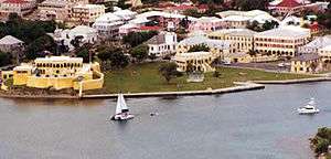
Aerial view of Christiansted | |
| Country |
|
| Territory |
|
| Island | Saint Croix |
| Established | September 1, 1734 |
| Population (2004) | |
| • Total | 3,000 |
Christiansted, U.S. Virgin Islands is the largest town on Saint Croix, one of the main islands comprising the United States Virgin Islands, a territory of the United States of America. It is a former capital of the Danish West Indies and home to the Christiansted National Historic Site. Christiansted as of 2004, had a population of about 3,000. The 2000 census population of the town was 2,637; that of the larger sub-district was 2,865.[1]
The town was founded by Frederick Moth after he was made governor of St.Croix in 1733. It has preserved the 18th-century Danish-style buildings constructed by African slaves. Solid stone buildings in pastel colors with bright red tile roofs line the cobblestone sidewalks, adding a touch of 18th-century European architectural style. Because the town was constructed by African slaves, there are many African influences in Christiansted's design as well, making it one of the few "African-Danish" towns in the world. The town's symmetry, with streets running at right angles to the waterfront, makes it popular for walking tours. The commercial area centers on King and Company streets, adjacent to the Christiansted National Historic Site. The residential area, including portions that were originally settlements for free blacks, extends inland and uphill from the commercial area.
The town has small hotels and many restaurants. Several scuba shops operate in the town, as the wharf has easy access to many diving attractions on the north side of the island. A small point of interest is Protestant Cay, a cay near Christiansted.
The botanist Julius von Röhr started a botanic garden in Christiansted in the 18th century and produced a number of landscapes of the island.
Economy
Seaborne Airlines previously had headquarters in Christiansted.[2]
Education
Public schools serving the community are operated by the St. Croix School District.
Climate
| Climate data for Christiansted Henry E Rohlsen International Airport | |||||||||||||
|---|---|---|---|---|---|---|---|---|---|---|---|---|---|
| Month | Jan | Feb | Mar | Apr | May | Jun | Jul | Aug | Sep | Oct | Nov | Dec | Year |
| Record high °F (°C) | 92 (33) |
93 (34) |
92 (33) |
93 (34) |
94 (34) |
97 (36) |
94 (34) |
95 (35) |
95 (35) |
98 (37) |
93 (34) |
92 (33) |
98 (37) |
| Average high °F (°C) | 84.0 (28.9) |
84.1 (28.9) |
84.7 (29.3) |
85.5 (29.7) |
86.4 (30.2) |
87.9 (31.1) |
88.6 (31.4) |
89.1 (31.7) |
88.7 (31.5) |
87.9 (31.1) |
86.2 (30.1) |
84.7 (29.3) |
86.5 (30.3) |
| Average low °F (°C) | 72.3 (22.4) |
72.2 (22.3) |
72.7 (22.6) |
74.4 (23.6) |
76.4 (24.7) |
78.0 (25.6) |
78.4 (25.8) |
78.6 (25.9) |
77.5 (25.3) |
76.6 (24.8) |
75.1 (23.9) |
73.5 (23.1) |
75.5 (24.2) |
| Record low °F (°C) | 59 (15) |
61 (16) |
60 (16) |
57 (14) |
63 (17) |
62 (17) |
64 (18) |
63 (17) |
58 (14) |
65 (18) |
52 (11) |
61 (16) |
52 (11) |
| Average precipitation inches (mm) | 2.10 (53.3) |
1.62 (41.1) |
1.48 (37.6) |
2.06 (52.3) |
3.98 (101.1) |
2.15 (54.6) |
3.04 (77.2) |
3.14 (79.8) |
4.33 (110) |
4.94 (125.5) |
5.83 (148.1) |
2.93 (74.4) |
37.60 (955) |
| Average precipitation days (≥ 0.01 in) | 15.8 | 13.0 | 11.6 | 10.1 | 12.1 | 11.1 | 16.5 | 15.2 | 14.3 | 16.5 | 15.6 | 17.2 | 168.9 |
| Source: NOAA (normals 1981−2010)[3] | |||||||||||||
Notable people
- Judah P. Benjamin, a Confederate politician and a seminal figure in the United States Civil War, was born in Christiansted while it was still a Danish colony.
- NBA player Tim Duncan (two-time MVP, five-time NBA Champion) is a native.
- Alexander Hamilton was a resident in 1765 after leaving his birthplace of Charlestown, Nevis at age 11. Upon reaching 17 years old, he moved from the then-Danish Virgin Islands to New York City and never returned to the Caribbean.
- Victor Borge was a long-time resident of Christiansted
- Audre Lorde died in Christiansted on November 17, 1992 at the age of 58. She was a famous poet.
- Carolyn Carter was born in Christiansted and is a model and beauty queen.
Gallery
 Christiansted, looking north.
 Christiansted, looking northeast.
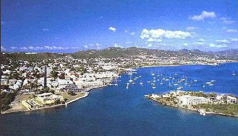 Christiansted, looking westward.
 Protestant Cay
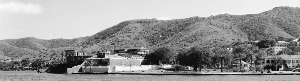 Fort Christiansværn in the 1930s.
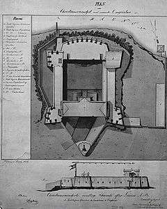 An 1836 plan of Fort Christiansværn, a historic building in Christiansted.
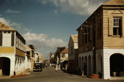 Company Street, The main shopping street, December 1944.
Notes
- ↑ Census press release
- ↑ "Contact Seaborne Airlines" (). Seaborne Airlines. February 7, 2006. Retrieved on April 18, 2015. "Postal Address: Seaborne Airlines Attn: Feedback 34 Strand Street Christiansted, VI 00820 "
- ↑ "NOWData - NOAA Online Weather Data". National Oceanic and Atmospheric Administration. Retrieved January 19, 2013.
References
- Lonely Planet's Cities Book: A Journey Through the Best Cities in the World p. 159.
External links
| Wikivoyage has a travel guide for Christiansted. |
- Christiansted National Historic Site (National Park Service)
-
 "Christiansted". The American Cyclopædia. 1879.
![]() Media related to Christiansted, U.S. Virgin Islands at Wikimedia Commons
Media related to Christiansted, U.S. Virgin Islands at Wikimedia Commons
Charlotte Amalie (capital) | |
| Topics |
|
| Government | |
| Cities | |
| Islands | |
| Parks | |
Coordinates: 17°45′N 64°45′W / 17.750°N 64.750°W