Chrobry fortified village in Szprotawa
The Chrobry fortified village (Polish: Gród Chrobry, German: Wallburg Chrobry), named for the Polish first crowned king Boleslaw Chrobry, and located in the town of Szprotawa (German: Sprottau), is an archaeological earthwork and a historical monument in the province of Lower Silesia, one of the largest of its kind in Poland.
Background
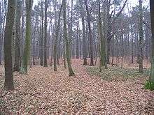
The site lies in the old Bóbr river valley, in the Park Słowiański nature reserve, and comprises a polygonal plateau of 4 hectares (9.9 acres) in size, which is raised 6 metres above its surroundings. The surface of the polygon is flat throughout, and has regular, steep inclined edges. The site lies between a bog and a marsh, which are now both partly dried out.
Prior to 1945 the site was known as the 'Nun Bush Hill' (German: Nonnenbuschberg).
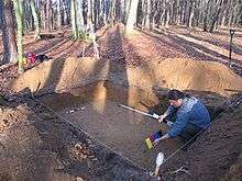
The date of the original structure is as yet unknown. German historian August Gloger (1927) described the site as dating from the times these lands were still Polish, but without providing particulars. Recently, Maciej Boryna, from the local historical museum Muzeum Ziemi Szprotawskiej, identified ceramic fragments from the site as Medieval, concluding that the structure was never completed or was only inhabited briefly.
As of 30 May 2007, thanks to the efforts of the local historical society Towarzystwo Bory Dolnośląskie, the site is now protected as a place of designated historical importance. Other, smaller archaeological earthworks can be found nearby.
References
- August Gloger: Beiträge zur Heimatkunde des Kreises Sprottau, 2nd edition, 1925
- Maciej Boryna: Szprotawa i okolice, 2nd edition, 2004
- Maciej Boryna: Gminna Ewidencja Zabytków Gminy Szprotawa, pos. nr. 49/2475, 2005
External links
Coordinates: 51°33′27″N 15°31′03″E / 51.55750°N 15.51750°E