Lower Silesia
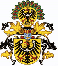
as drawn by Hugo Gerard Ströhl (1851–1919)
Lower Silesia (Polish: Dolny Śląsk; Czech: Dolní Slezsko, Latin: Silesia Inferior; German: Niederschlesien; Silesian German: Niederschläsing; Silesian: Dolny Ślůnsk) is the northwestern part of the historical and geographical region of Silesia; Upper Silesia is to the southeast.
Throughout its history Lower Silesia has been under the control of the medieval Kingdom of Poland, the Kingdom of Bohemia and the Austrian Habsburg Monarchy from 1526. In 1742 nearly all of the region was annexed by the Kingdom of Prussia and became part of the German Empire in 1871, except for a small part which formed the southern part of the Lower Silesian Duchy of Nysa and had been incorporated into Austrian Silesia in 1742. After 1945 the main part of the former Prussian Province of Lower Silesia fell to the Republic of Poland, while a smaller part west of the Oder-Neisse line remained within East Germany.
Geography
.png)
cyan outline = mediæval Bohemian crown land (after the loss of Krosno)
yellow outline = Prussian Silesia as of 1815 (with Upper Lusatian gains and Kłodzko, but without Austrian Silesia)
Lower Silesia is located mostly in the basin of the middle Oder River with its historic capital in Wrocław.
The southern border of Lower Silesia is mapped by the mountain ridge of the Western and Central Sudetes, which since the High Middle Ages formed the border between Polish Silesia and the historic Bohemian region of the present-day Czech Republic. The Bóbr and Kwisa rivers are considered being the original western border with the Lusatias, however the Silesian Duchy of Żagań reached up to the Neisse river, including two villages (Pechern and Neudorf) on the western shore, which became Silesian in 1413.
The later Silesian Province of Prussia further comprised the adjacent lands of historic Upper Lusatia ceded by the Kingdom of Saxony after the Napoleonic Wars in 1815, its westernmost point could be found as far west as the small village of Lindenau (now belonging to the German state of Brandenburg). To the north, Lower Silesia originally stretched up to Świebodzin and Krosno Odrzańskie, which was acquired by the Margraves of Brandenburg in 1482. The Barycz river forms the border with historic Greater Poland in the northeast, the Upper Silesian lands lie to the southeast.
Administratively Polish Lower Silesia is shared between Lower Silesian Voivodeship (except for the Upper Lusatian counties of Lubań and Zgorzelec, and former Bohemian Kłodzko), the southern part of Lubusz Voivodeship (i.e. the counties of Krosno Odrzańskie, Nowa Sól, Świebodzin, Żagań and Zielona Góra with the city of Zielona Góra, as well as western Opole Voivodeship (the counties of Brzeg, Oleśnica and Nysa).
The tiny part of the former Duchy of Żagań on the western shore of the Neisse is today part of the Krauschwitz municipality in the Görlitz district of Saxony, the larger Upper Lusatian parts of Prussian Silesia ("Silesian Upper Lusatia") west of the Neisse comprised the town of Görlitz and the former district of Hoyerswerda, which today forms the northern part of the Saxon Görlitz and Bautzen districts as well as the southern part of the Oberspreewald-Lausitz district in Brandenburg. The southern part of the former Duchy of Nysa, which fell to Austrian Silesia in 1742, namely the Jeseník District and Heřmanovice, Mnichov and Železná, as well as parts of Vrbno pod Pradědem in the Bruntál District, today belongs to the Czech Republic
Sudetes

The Sudetes are a geologically diverse mountain range that stretches for 280 kilometres (170 miles) from the Lusatian Highlands in the west and to the Moravian Gate in the east. They are topographically divided into Western, Central and Eastern Sudetes.
The Lower Silesian section of the Sudetes comprises the Jizera Mountains (highest peak: Wysoka Kopa, 1,126 metres or 3,694 feet), where the tripoint with Upper Lusatia and Bohemia is located near the Smrk summit, along with the adjacent Karkonosze (German: Riesengebirge, also known as in English: Giant's Mountains) (highest: Śnieżka, 1,602 m or 5,256 ft); Rudawy Janowickie (Skalnik, 945 m or 3,100 ft); Owl Mountains (Wielka Sowa, 1,015 m or 3,330 ft); Stone Mountains (Waligóra 936 m or 3,071 ft); Wałbrzych Mountains (Borowa 853 m or 2,799 ft) and the Kaczawskie Mountains (Skopiec, 724 m or 2,375 ft) with Ostrzyca, 501 m or 1,644 ft - they surround the Jelenia Góra valley, 420–450 m or 1,380–1,480 ft; Ślęża Massif (Mount Ślęża 718 m or 2,356 ft).
Silesian Lowland
The adjacent Silesian Lowland includes the Silesian Lowlands and the Silesian-Lusatian Lowlands. These two lowlands are separated with each other by Dolina Kaczawy, and from the Sudetes by a steep morphological edge located along the Sudeten Marginal Fault, extended from Bolesławiec (the Northwest) to Złoty Stok (the Southeast). The southern part of the Lowland includes The Sudeten Foreland, consisting of quite low Wzgórze Strzegomskie, 232 m or 761 ft, Grupa Ślęży (Mount Ślęża, 718 m or 2,356 ft), and Wzgórza Niemczańsko-Strzelińskie (Gromnik Mountain, 392 m or 1,286 ft). Lower hills occur also in areas of Obniżenie Sudeckie, Świdnik, and Kotlina Dzierżoniowska. The eastern part of Silesian Lowland consists of the wide Silesian Lowlands, located along banks of the Oder River. The eastern part includes also Równina Wrocławska with its surrounding lands: Równina Oleśnicka, Wysoczyzna Średzka, Równina Grodkowska and Niemodlińska. Dolina Dolnej Kaczawy (Kotlina Legnicka) separates the Silesian Lowlands from the Silesian-Lusatian Lowlands, which includes Wysoczyzna Lubińsko-Chocianowska, Dolina Szprotawy, and wide areas of Bory Dolnośląskie, located to the north from the Bolesławiec-Zgorzelec road. From the North, the lowlands are delimited by Wał Trzebnicki, consisting of hills that are 200 km (120 mi) long and over 150 m (490 ft) high, in comparison to neighboring lowlands, Kobyla Mountain, 284 m (932 ft). The range of hills includes: Wzgórza Dalkowskie, Wzgórza Trzebnickie, Wzgórza Twardogórskie, and Wzgórza Ostrzeszowskie. Obniżenie Milicko-Głogowskie, with Kotlina Żmigrodzka and Milicka, is located in the northern part, within the hills.
The region of the lowlands is coated with a thick layer of glacial elements (sand, gravel, clay) that covers more diverse relief of the older ground. Generally flat and wide bottoms of the valleys are padded with river settlements. Slopes of the hills over 180–200 m (590–660 ft) are coated with fertile clays and therefore, to begin with the Paleozoic era, they became the lands for people to settle and cultivate intensively. Later form of economy caused almost complete deforestation of the slopes. Not only fertile grounds, but also mild climate is conductive to development of agriculture and market gardening. The annual average temperature of the Wrocław area is 9.5 °C (49.1 °F). Average temperature of the hottest month (July) is 19 °C (66 °F), and −0.5 °C (31.1 °F) of the coldest month (January). The average amount of rainfall is 500–620 millimetres (20–24 inches), with its maximum in July and minimum in February. The snow layer disappears after 45 days. The winds, similar to those appearing in the West side of Poland, are West and Southwest.
Sudeten rivers are characterized by changeable water rates, and high pollution resulting from large industrialization of the area. The greatest rivers are Nysa Kłodzka, which is the source of drinking water for Wrocław (the water is drawn by special channel); Stobrawa, Oława, Ślęza, Bystrzyca with its tributaries—Strzegomka and Piława; Widawa, Średzka Woda, Kaczawa with Nysa Szalona and Czarna Woda. There is also the largest right-bank tributary of the area, Barycz. The other guite large rivers—Bóbr, Kwisa, and Lusatian Neisse—flow into Oder River beyond Lower Silesian borders. The majority of the rivers is regulated and their basins are improved, which is conductive to the proper water economy. The characteristic feature of the lowlands landscape is the lack of lakes. The region of Legnica is the only place where a dozen or so of small lakes survived, but the majority of them is already disappearing. The largest one is Jezioro Kunickie (95 hectares or 230 acres), Jezioro Koskowickie (50 ha or 120 acres), Jezioro Jaśkowickie (24 ha or 59 acres) and Tatarak (19.5 ha or 48 acres). In contrast to the number of lakes, there are large groups of artificial ponds founded in Barycz basin, in the Middle Ages. Their total area amounts around 80 square kilometres (31 square miles), and the largest ponds (Stary Staw, Łosiowy Staw, Staw Niezgoda, Staw Mewi Duży, and Grabownica) come to 200–300 ha (490–740 acres).
The primeval flora has been transformed significantly as a result of deforestation and cultivation. The largest forest complexes are Bory Dolnośląskie (3,150 km2 or 1,220 sq mi), Bory Stobrawskie in Stobrawa and Widawa areas, and smaller fragments of forests in Barycz and Oder River valleys. These forests are kind of multi-species deciduous forests, occurring in fertile grounds. The Oder River valley is reach in groups of mixed forests (beech, oak, hornbeam, sycamore maple, and pine). These forests, with protected status, are: Zwierzyniec, Kanigóra near Oława, Dublany, Kępa Opatowicka near Wrocław, Zabór near Przedmoście, and Lubiąż. The other forest areas are: The Natural Park in Orsk, the areas of Jodłowice, Wzgórze Joanny near Milicz, and Gola near Twardogóra. Such types of forest like those which are the mainstay for wild game or nurseries, are inaccessible because of permanent fire hazard. Territories partly accessible (marked specially) are located in areas of Góra Śląska, Oborniki Śląskie, Wołowa, in the Oder River valley, and in Wzgórza Niemczańsko-Strzelińskie.
Flora
The flora of Lower Silesia is specific and different for each zone. From the bottoms to the tops, plants form groups that are arranged in wide or narrow belts, called floral zones. Subsequently, these zones are divided into narrower belts, called vegetation belts.
The zone of mountain forest is divided into two belts: subalpine and lower subalpine forest. Above, there is a forestless zone divided into the subalpine belt with dwarf pine, and the alpine belt without shrubs. This vegetation is glacial; the former vegetation—from the Tertiary—was destroyed by the climate of the Ice Age. Along with glaciation from the North, some tundra plants appeared, for example downy willow (Salix lapponum) and cloudberry (Rubus chamaemorus). The flora of Lower Silesia is strongly influenced by geological and climatic history. The vegetation is formed by species deriving from various geographic regions. Particular regions are represented by:
- Central European species: fir (Abies alba), beech (Fagus silvatica), oak (Quercus petraea), maple (Acer pseudoplatanus)
- European Syberian species: European spindle-tree (Evonymus europaea), alder (Alnus glutinosa), wicker (Salix purpurea)
- Boreal-Sub arctic species: cress (Cardamine pratensis), yellow marsh marigold (Caltha palustris), liverleaf (Hepatica nobilis)
- Boreal-Arctic species: bearberry (Arctostaphylos uva-ursi), dwarf willow (Salix herbacea), black crowberry (Empetrum nigrum), Sudetic Lousewort (Pedicularis sudetica), alpine saxifrage (Micranthes nivalis), cloudberry (Rubus chamaemorus), Lake Quillwort (Isoëtes lacustris)
- Alpine species: Alpine Bastard Toadflax (Thesium alpinium), Alpine coltsfoot (Homogyne alpina), mountain avens (Geum montanum), Mountain Pine (Pinus mugo)
- Sudetic and Sudetic-Carpathian species: mossy saxifrage (Saxifraga moschata ssp. Basaltica), Sudetic lousewort (Pedicularis sudetica)
Lower subalpine forest
Lower subalpine forest (Polish: Regiel Dolny), 450–1,000 m (1,480–3,280 ft), is characterized by deciduous or mixed forest. The fragments of forests similar to natural complexes of pine-fir-beech with admixture of larch, sycamore maple and lime occur near the Szklarski waterfall, in the Jagniątkowski complex, and Chojnik Mountain. Particular species of trees have different climatic requirements. The lowest parts are covered with oak and ash, up to 500 m (1,600 ft). On the level of 500–600 m (2,000 ft) occurs pine; in the higher parts, up to 800 m (2,600 ft), there occurs European larch; and above 800 m, fir and beech.
Despite of transformation of the basic tree vegetation, the same form of undergrowth survived. There occurs: daphne mezereum, red elderberry, hazel, platanthera bifolia, sweet woodruff, herb paris, cranberry, wood sorrel, chickweed wintergreen, Common Cow-wheat and lily of the valley. The parts over 800 m are mainly covered with grasses, purple small-reeds, cranberries, and willow gentian.
In highlighted places, on meadows, and along roads, there occurs: spotted orchid, bugleweed, yellow archangel, arnica montana, sword-leaved helleborine, rosebay willowherb, groundsel, and foxglove. Along riversides, there occurs white butterbur.
Pine forests are rich in spruces, which are permanently weakened by atmospheric factors. Frayed roots are easily infected by harmful fungus and insects. The most damaging is honey mushroom, with edible specimen, which grows in pulp, between the bark and timber, causing the death of tree. The other damaging fungus is bracket fungus, which destroys roots and trunks from the inside. The honey mushroom devastates the tree within a few months, and the bracket fungus, within a few years, as a result of mechanic changes in wood structure.
History
Ancient history
At the close of the Ice Age, the first man appeared at the Silesian Lowland. In the Mesolithic (7,000 years ago), the first nomadic people settled in Lower Silesia, living in caves and primitive chalets. They were collectors, hunters, and fishers, and used weapons and other tools made of stone and wood. In the Upper Paleolithic, the oldest human remains of the nomadic people, which were 40,000 years old, were found in a tomb in Tyniec on the river Ślęża.
In the Neolithic (4000–1700 BC), began the process of transformation into a settled way of life. The first rural settlements were made, as people began to farm and breed animals. Mining, pottery, and weaving are dated to this period. Serpentinite quarries came into existence, of which Silesian hatchets were made, and near Jordanów Śląski, people extracted nephrite that was transformed into diverse tools. In the Bronze Age (1700–1500 BC), the evolution of different cultures developed to the existence of Unetice culture that affected the existence of Trzciniec culture. In the next periods since c. 750 BC, it encompasses all of Europe.
Early history
In the La Tène culture period, Lower Silesia was inhabited by the Celts, who had their main place of cult on the Mount Ślęża. Their stony statues situated on and around this hill were later worshipped by the Slavic tribes that came here around the sixth century BC. Magna Germania (second century) records that between the Celtic and the Slavic period, Lower Silesia was inhabited by a number of Germanic tribes. Among them, are the Vandals, the Lugii, and the Silingi, who might have given the Silesia region its name, though it is unclear and thus disputed. With the Germanic tribes leaving westward during the Migration Period, a number of new peoples arrived in Silesia from Sarmatia, Asia Minor, and the Asian steppes from the beginning of the sixth century.
The Bavarian Geographer (c. 845) referred to the West Slavic Ślężanie (the other possible source of the region's Śląsk and later Silesia name), centered on Niemcza, and Dziadoszanie tribes, while a 1086 document issued by Bishop Jaromir of Prague listed the Zlasane, Trebovane, Poborane, and Dedositze. At the same time, Upper Silesia was inhabited by the Opolanie, Lupiglaa, and Golenshitse tribes. In the late 9th century, the territory was subject to the Great Moravian realm of Prince Svatopluk I and from about 906 came under the rule of the Přemyslid duke Spytihnev I of Bohemia and his successors Vratislaus I, the alleged founder of Wrocław (Czech: Vratislav), and Boleslaus the Cruel.
Piast Kingdom of Poland
Meanwhile, the West Slavic Polans had established a first duchy under the Piast dynasty in the adjacent Greater Polish lands in the north. About 990 Silesia was conquered and incorporated into the first Polish state by the Piast duke Mieszko I, who had gained the support of Emperor Otto II against the Bohemian duke Boleslaus II.
In 1000 his son and successor Bolesław I Chrobry founded the Diocese of Wrocław, which, together with the Bishoprics of Kraków and Kołobrzeg, was placed under the Archbishopric of Gniezno in Greater Poland, founded by Emperor Otto III at the Congress of Gniezno in the same year. The ecclesial suzerainty of Gniezno over Wrocław lasted until 1821. After a temporary shift to Bohemia in the first half of the 11th century, Lower Silesia continued to be an integral part of the Polish state until the end of its fragmentation period when all Polish claims on this land were finally renounced in favour of the Bohemian kingdom in 1348.
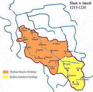
The Duchy of Silesia was first split into lower and upper parts in 1172 during the period of Poland's feudal fragmentation, when the land was divided between two sons of former High Duke Władysław II. The elder Bolesław the Tall ruled over Lower Silesia with his capital in Wrocław (then known as Vratislav, Wrotizla, or Prezla), and younger Mieszko Tanglefoot ruled over Upper Silesia with his capital at first in Racibórz, from 1202 in Opole. Later Silesia was divided into as many as 17 duchies. The duchies of Lower Silesia in the 14th century (German names in italics):
- Silesia–Wrocław (Breslau)
The Bohemian Crown, Austria and Prussia
With the 1335 Treaty of Trentschin and the 1348 Treaty of Namslau, most of the Silesian duchies were ruled by the Silesian Piast dukes under the feudal overlordship of the Bohemian kings, and thus became part of the Crown of Bohemia. In 1476 the Crossen district became part of the Margraviate of Brandenburg, when the widow of the Piast ruler, Barbara von Brandenburg, daughter of Elector Albert Achilles, inherited Crossen. In 1526 Silesia was acquired by Austria's Habsburg Monarchy after the death of King Louis II of Bohemia. Brandenburg contested the inheritance, citing a treaty made with Frederick II of Legnica, but Silesia largely remained under Habsburg control until 1742.
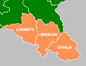
Most of Lower Silesia, except for southern part of the Duchy of Nysa, became part of the Kingdom of Prussia in 1742 after the First Silesian War by the 1742 Treaty of Breslau. In 1815 it became part of the Prussian Silesia Province, which was divided into the two Lower Silesian administrative regions (Regierungsbezirke) of Liegnitz and Breslau (sometimes also referred to as Middle Silesia), and Upper Silesian Oppeln (including the Lower Silesian districts of Nysa and Grodków). The western Liegnitz region had been enlarged by the incorporated Upper Lusatian districts of Lauban, Görlitz, Rothenburg and Hoyerswerda, all seized from Saxony after the Napoleonic Wars.
By the beginning of the 20th century Lower Silesia had an almost entirely German-speaking and ethnic German population, with the exception of a small Polish-speaking area in the northeastern part of the district of Namslau, Syców and Milicz and a 9% Czech-speaking minority in the rural area around Strehlen. After the First World War, Upper Silesia was divided between the German Weimar Republic, the Second Polish Republic, and the state of Czechoslovakia, while the Prussian Lower Silesia remained in Germany and was re-organized into the Province of Lower Silesia of the Free State of Prussia consisting of the Breslau and Liegnitz regions.
After 1945
Following the end of World War II, all territories east of the Oder-Neisse line were placed under Polish administration according to the Potsdam Agreement and became part of the Republic of Poland. Under those terms almost all of historic Lower Silesia became part of Poland as part of the "Recovered Territories". Germany retained the small portion of the former Prussian Province of Lower Silesia to the west of the Oder-Neisse line. The territory's German populations fled or were expelled and replaced with Poles, many of whom had themselves been expelled from Polish areas annexed by the Soviet Union.
From 1945–1975 Lower Silesia was administered within the Wrocław Voivodeship. As a result of the Local Government Reorganisation Act (1975), Poland's administration was reorganized into 49 voivodeships, four of them in Lower Silesia: Jelenia Góra, Legnica, Wałbrzych, and Wrocław Voivodeships (1975–1998). As a result of the Local Government Reorganisation Act of 1998, these four provinces were joined into the Lower Silesian Voivodeship (effective 1 January 1999), whose capital is Wrocław.
Population
Currently, the majority of population of Lower Silesia are not of Silesian descent, because after World War II, almost the entire population of Lower Silesia was replaced; pre-war inhabitants fled the area, and the region was settled by migrants from various regions of Poland. By far the largest part of the population of Lower Silesia has its roots in the eastern areas of pre-war Poland.
Towns of the historical Lower Silesia

Towns with over 20,000 inhabitants (German names in brackets):
- Wrocław (Breslau)
- Wałbrzych (Waldenburg)
- Nysa (Neisse)
- Brzeg (Brieg)
- Lądek Zdrój (Bad Landeck)
- Legnica (Liegnitz)
- Jelenia Góra (Hirschberg)
- Lubin (Lüben)
- Głogów (Glogau)
- Świdnica (Schweidnitz)
- Bolesławiec (Bunzlau)
- Oleśnica (Oels)
- Jawor (Jauer)
- Kamienna Góra (Landeshut in Schlesien)
- Oława (Ohlau)
- Kłodzko (Glatz)
- Nowa Ruda (Neurode)
- Dzierżoniów (Reichenbach im Eulengebirge)
- Bielawa (Langenbielau)
- Polkowice (Polkwitz)
Silesian traditions in Upper Lusatia

For 130 years (from 1815 to 1945) parts of formerly Saxon territories of Upper Lusatia formed the most westward part of the Prussian Province of Silesia and later of Lower Silesia. During this time Silesian culture and the Silesian German dialect spread into this region with its centre Görlitz. The expulsion of the Germans from the east of Oder Neisse line led to an additional settlement of German Silesians in this region. Due to these facts, some of the inhabitants of this region still consider themselves Silesian and cultivate Silesian customs. One of their special privileges is the right to use the Lower Silesian flag and coat of arms which is guaranteed to them by the Saxon Constitution of 1992. The Evangelical Church of Silesia in Upper Lusatia, meanwhile, merged with the one of Berlin and Brandenburg to form the Evangelical Church of Berlin-Brandenburg-Silesian Upper Lusatia.
Towns
The main cities within the former province of Lower Silesia west of the Oder-Neisse line are (Upper Sorbian names in italics):
- Görlitz (Zhorjelc)
- Hoyerswerda (Wojerecy)
- Weißwasser/O.L. (Běła Woda)
- Niesky (Niska)
The main Lusatian cities within the former province of Lower Silesia east of Lusatian Neisse, now within Lower Silesian Voivodship are:
Tourism

The international airport is located in Wrocław - Wrocław – Copernicus Airport.
The A4 motorway and A18 motorway run through Lower Silesia.
Lower Silesia is one of the most visited regions in Poland. It is famous for a large number of castles and palaces (more than 100), inter alia: Książ Castle, Czocha Castle, Grodziec castle, Gola Dzierżoniowska Castle. There is also a lot in the Jelenia Góra valley.
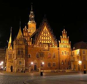
The most widely visited city is Wrocław.
The Festival of Good Beer is held every year on the second weekend of June.
Other highlights: Kłodzko Fortress, Fort Silberberg, Project Riese, Wambierzyce, Legnickie Pole, Oleśnica Mała, Lubiąż Abbey, Krzeszów, Henryków, Vang stave church, Churches of Peace, Mount Ślęża, Table Mountains, Owl Mountains, Karkonosze, The Main Trail Sudetes, Barycz Valley Landscape Park.
Sport
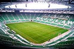
The most popular football club in Lower Silesia is Śląsk Wrocław.
Every year in September, the capital of the province - Wrocław is Wrocław Marathon
See also
Sources
- Urbanek M., (2003), Dolny Śląsk. Siedem stron świata., MAK publishing, Wrocław, p. 240 + CD-ROM
- Śląsk na weekend – touristic guide, Pascal publishing
External links
| Wikimedia Commons has media related to Lower Silesia. |
Silesia topics | |||||||||||||||||||||||||||||||||||||||||||||||
|---|---|---|---|---|---|---|---|---|---|---|---|---|---|---|---|---|---|---|---|---|---|---|---|---|---|---|---|---|---|---|---|---|---|---|---|---|---|---|---|---|---|---|---|---|---|---|---|
| |||||||||||||||||||||||||||||||||||||||||||||||
| |||||||||||||||||||||||||||||||||||||||||||||||
| |||||||||||||||||||||||||||||||||||||||||||||||
| |||||||||||||||||||||||||||||||||||||||||||||||
| |||||||||||||||||||||||||||||||||||||||||||||||