Churchbridge, Cornwall
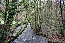
The West Looe River looking downstream from Churchbridge
Churchbridge is a hamlet in Cornwall, England.[1] It is a mile west of Duloe, and is situated on the West Looe River.[2] Both banks of the river are wooded, and to the north of the bridge is a disused quarry and Tremadart Mills,[3] marked as a corn mill on the 1882 map.[4]
References
- ↑ Ordnance Survey: Landranger map sheet 201 Plymouth & Launceston' (Map). Ordnance Survey. ISBN 978-0-319-23287-3.
- ↑ Ordnance Survey One-inch Map of Great Britain; Bodmin and Launceston, sheet 186. 1961.
- ↑ Ordnance Survey, 1:2,500 map, 2010
- ↑ Ordnance Survey, 1:2,500 map, 1882, available here Archived April 30, 2012, at the Wayback Machine.
Coordinates: 50°24′00″N 4°30′25″W / 50.400°N 4.507°W
Cornwall Portal | |
| Unitary authorities | |
| Major settlements |
|
| Rivers | |
| Topics | |
This article is issued from Wikipedia - version of the 11/24/2016. The text is available under the Creative Commons Attribution/Share Alike but additional terms may apply for the media files.