Santa Clara, Cuba
| Santa Clara | |||
|---|---|---|---|
| City | |||
|
Two views of Santa Clara painted by Leonardo Barañano and lithographed by famous French-Cuban artist Eduardo Laplante in 1858. Work appeared in the collections "Cuba pintoresca", "Isla de Cuba pintoresca" and "Album pintoresco de Cuba" printed between 1837 and 1858. | |||
| |||
.png) Santa Clara municipality (red) within Province of Las Villas (yellow) and Cuba | |||
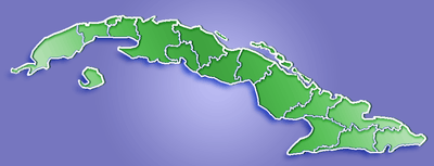 Location of Santa Clara in Cuba | |||
| Coordinates: 22°24′24.91″N 79°57′53.78″W / 22.4069194°N 79.9649389°WCoordinates: 22°24′24.91″N 79°57′53.78″W / 22.4069194°N 79.9649389°W | |||
| Country |
| ||
| Province | Villa Clara | ||
| Founded | July 15th, 1689 | ||
| Established | January 1, 1690[1] | ||
| Area[2] | |||
| • Total | 514 km2 (198 sq mi) | ||
| Elevation | 125 m (410 ft) | ||
| Population (2011)[3] | |||
| • Total | 242,402 | ||
| • Density | 470/km2 (1,200/sq mi) | ||
| Demonym(s) | Santaclareño | ||
| Time zone | EST (UTC-5) | ||
| Postal code | 50100 | ||
| Area code(s) | +53 422 | ||

.png)
Santa Clara is the capital city of the Cuban province of Villa Clara. It is located in the most central region of the province and almost in the most central region of the country. With a population near a quarter million, Santa Clara is the 5th largest Cuban city by population.
History
Santa Clara was founded by 175 people on July 15, 1689. One hundred and thirty-eight of them were represented by two large families already living in the area and, therefore, owners of the land next to the new city. The other 37 came from 7 other families, a priest and a governor, all of them originating in the coastal city of “San Juan de los Remedios”.
The population of Remedios was torn between the option of leaving their city, constantly besieged by pirate attacks, or staying in place. While most of them finally decided to stay, these 37 persons traveled south and, on June 1, 1689 they arrived to the hill where they rejoined the other two existing families. A mass was given under a supposed Tamarind tree and the city was born. Since then, the place under the tree is known as “Loma Del Carmen” (Carmen’s Hill). A second generation church exists in a beautiful park along the place with a monument commemorating the event surrounded by a fourth generation Tamarind tree.
At its beginnings, the settlement was called Cayo Nuevo, then Dos Cayos, Villa Nueva de Santa Clara, Pueblo Nuevo de Antón Díaz, Villa Clara and finally Santa Clara.
Construction of the city began not far from Carmen’s Hill. Following the Spanish standards, a perfect squared layout with a central plaza (Plaza Mayor today Parque Vidal) was developed. The first buildings erected were the Cabildo (City Council) and a modest palm tree church. This building was enhanced in 1725 to a brick one, and stayed the center of the Parque Vidal until August 22, 1923 when it was torn down in order to expand the plaza and build a new church close by. Back then, and still nowadays, this decision, taken by the mayor, was highly criticized. The building, while not a gem of architecture, was not entirely unpleasant to the eye and certainly an example of the older colonial structure in the city. Resulting from this expropriation by the City Council, a complaint was raised by religious figures and a total of 77 850.00 pesos were paid in fines to the Church, a considerable sum that would represent millions of pesos today.
Soon after the foundation, a theater, a chamber of commerce, meeting clubs, public libraries and dance halls were erected as well. The position of the city, almost in the very center of the country, made it as a perfect halt and a great communication link, east-west and north-south, creating a slow but unstoppable growth. By the 19th century, Santa Clara was bigger and more populated than the rest of the towns around, including what was once Remedios. As a necessary stop between Havana and the east of the country, the city gained the title of Las Villas province capital.
Marta Abreu de Estévez
Presently, there are two well-known figures associated with Santa Clara: Marta Abreu de Estévez, a beloved native daughter known as "the Benefactress of the City" and Ernesto Che Guevara, where he is buried, for having waged there the final battle of the revolution that toppled the Fulgencio Batista government in 1958.
Marta Abreu's acclaim is due to the numerous projects she and her family promoted through their monetary donations intended to enhance the life of all citizens of Santa Clara. Marta Abreu and her husband Luis Estévez, who became the first Vice President of the young republic in 1902, were well-known sympathizers and contributors to the Cuban rebels cause during the War of Cuban Independence against Spain (known in the United States as the Spanish–American War).
Marta's legacy can be seen all over the city: an electric plant building, several schools, an asylum, public laundry stations by the Belico river (two of them still exist, unfortunately in poor conditions), the fire station that can be seen just a block off the Parque Vidal, the train station near Carmen's Hill, but first and foremost the "Teatro La Caridad" (a theater named in honor of the patron saint of Cuba, La Virgen de la Caridad – Our Lady of Charity). The theater can be admired in one of the corners of the Parque Vidal in the center of the city. Marta was the project's sole financial sponsor. She personally supervised its design and construction. Although the building is not as grandiose as Terrier Theater in Cienfuegos City, the concept behind its founding makes it most worthy: the proceeds of the theater were destined for the support of the two schools Marta founded for poor children of the city. The schools, one for girls and one for boys, were located just behind the theater. La Caridad Theater is one of the seven Big Theaters from the colonial era still standing. It offers an exquisite architecture and amazing interior. Marta finally donated her own palace to the city; it was used as a Provincial Government Palace and transformed into a Public Library afterwards. Today, it houses the "Biblioteca Marti" (Marti Library), also located on the Parque Vidal, and represents a beautiful example of Neo Classical architecture with finely decorated interiors. Santa Clara's University is named after her. Marta is buried in the Colón cemetery of Havana.
Battle of Santa Clara

Santa Clara was the site of the last battle in the Cuban Revolution in late 1958. There were two guerrilla columns that attacked the city, one led by Ernesto Che Guevara and the other led by Camilo Cienfuegos. Guevara's column first captured the garrison at Fomento. Then, using a bulldozer, Guevara's soldiers destroyed railroad tracks and derailed a train full of troops and supplies sent by Batista. At the same time, Cienfuegos's column defeated an army garrison at the Battle of Yaguajay not far from town. On December 31, 1958, the combined forces of Guevara and Cienfuegos (along with other revolutionaries under William Alexander Morgan) attacked Santa Clara. The battle was chaotic, the defenders were demoralized, some fought, others surrendered without a shot. By the afternoon, the city was captured. This victory for Castro's troops is seen as the decisive moment in the Cuban Revolution as Batista fled Cuba less than 12 hours later.
Geography
Overview
Located on a plain below a hillside, in the middle of its province, Santa Clara is 71.5 km far from the Caribbean Sea (at Cienfuegos) and 51.7 km from the Atlantic Ocean (at Caibarién). The municipality borders with the municipalities of Cifuentes, Camajuaní, Placetas, Manicaragua and Ranchuelo.[4]
The city is divided into several wards (Repartos):
|
|
|
Climate
| Climate data for Santa Clara | |||||||||||||
|---|---|---|---|---|---|---|---|---|---|---|---|---|---|
| Month | Jan | Feb | Mar | Apr | May | Jun | Jul | Aug | Sep | Oct | Nov | Dec | Year |
| Average high °C (°F) | 27 (81) |
28 (82) |
29 (84) |
29 (85) |
31 (87) |
32 (89) |
32 (90) |
32 (90) |
32 (89) |
31 (88) |
28 (83) |
28 (82) |
30 (86) |
| Average low °C (°F) | 17 (63) |
17 (62) |
18 (64) |
19 (67) |
21 (69) |
22 (71) |
22 (72) |
22 (72) |
22 (71) |
22 (71) |
19 (67) |
18 (64) |
20 (68) |
| Average precipitation mm (inches) | 18 (0.7) |
30 (1) |
33 (1.3) |
46 (1.8) |
119 (4.7) |
150 (6) |
122 (4.8) |
160 (6.3) |
173 (6.8) |
160 (6.3) |
41 (1.6) |
23 (0.9) |
1,072 (42.2) |
| Source: Weatherbase [5] | |||||||||||||
Demographics
_in_Santa_Clara_city%2C_Cuba_-2012.jpg)
In 2004, the municipality of Santa Clara had a population of 237,581.[3] With a total area of 514 km2 (198 sq mi),[2] it has a population density of 462.2/km2 (1,197/sq mi).
Attractions
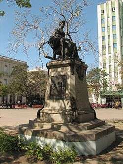
In Santa Clara's center is a park (Parque Vidal) and it is laid on an entire square block. In the park there is a statue of Marta Abreu, a person much loved by the people of Santa Clara. Bordering the park is the Santa Clara Libre (formerly the Santa Clara Hilton), "Gran Hotel", Teatro de La Caridad (a National Monument of Cuba.[6]), the Plaza del Mercado Central, the former City Hall and the Colonia Española de Santa Clara center of dance, offers the most attractive and unique traditional customs of hinterland Cuba.
Parque Vidal is probably one of the most typical places in Cuba. During the afternoons, people (especially singles) visit the park to meet others. Although not widely practiced in recent times, the custom was to walk the park around and around. The women walk the inner part of the park, while the men walk the outer side. Another lost custom was for the locals to set up a platform and offer improvisations with their guitars on late Sunday afternoons. For that day they dressed with their Guayaberas and highly polished shoes.
Santa Clara is home to a mausoleum which houses the remains of Che Guevara and sixteen of his fellow combatants killed in 1967 during the Bolivia campaign. There is also a reconstruction of Guevara derailing the train during the Battle of Santa Clara.
Prior to 1 January 1977, Santa Clara was located in Las Villas Province. On that date, as part of a general administrating reordering of Cuba's provinces, Las Villas province was reordered into the provinces of Villa Clara, Cienfuegos, and Sancti Spíritus. Santa Clara is in the province now known as Villa Clara.
Other local landmarks include:
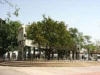
- Parque del Carmen (Carmen's Park)– City's Foundation Site.
- Parque de los Martires (Martyrs Park).
- Parque de la Pastora (Our Lady Shepherdess Park). Photos of Our Lady Shepherdess Church and Park in Santa Clara city.
- Parque de la Justicia (Justice’s Park). Photos of Santa Clara, Cuba, supreme court in Justice's Park.
- Parque del Tren Blindado (The Armored Train Park-Museum), a National Monument of Cuba.[6]
- Mausoleo Che Guevara (Monument and Mausoleum of Ernesto "Che" Guevara).
- Catedral de Santa Clara de Asís (Saint Claire of Asis Cathedral).
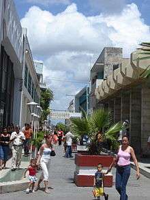
- Boulevard 1889. Photos of Santa Clara, Cuba, Pedestrian Boulevard.
- Centro Cultural El Mejunje (Cultural Centre "El Mejunje").
- Loma del Capiro, hill overlooking the city
- University "Marta Abreu" of Las Villas is the province's secondary education institution.
Gallery
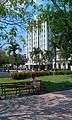 "Santa Clara Libre hotel" across Vidal square was during the 50's and 60's the tallest building outside Havana (Follow link for building's history and facts in Spanish)
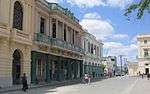 Street in Parque Vidal, the heart of Santa Clara city. The Municipal Government building, Central Hotel and former Royal Bank of Canada are visible in the row at the left. Far back a corner of Teatro La Caridad is visible.
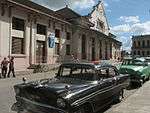 Train Station a gift from Marta Abreu to the city.
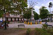 Marta Abreu train station across Martyrs Park in Santa Clara, Cuba. At the center the truncated pillar monument dedicated to the Marty's of the Colonial Independence War. Photo from 2010
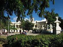 Vidal Park in Santa Clara's downtown.
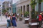 Eclectic architecture in Santa Clara's pedestrian boulevard.
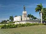 Che Guevara's Monument and museum.
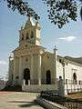 Carmen Church the oldest one in city and point of origin of it.
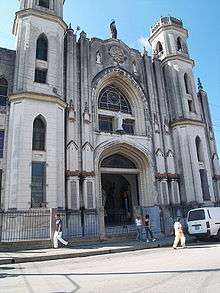 City's Cathedral.
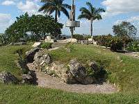 Trenches made by rebels under Che Guevara orders in Loma del Capiro.
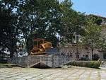 Part of the monument to the armored train.
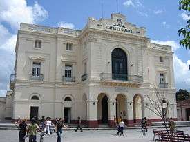 Teatro La Caridad.
 Former City Hall now Martí Library.
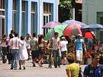 People hanging around flower vendors in Parque Vidal
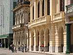 Historic eclectic buildings serving as Cultural Centre and Radio Station in Parque Vidal
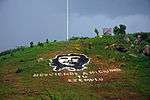 Image of Che Guevara on a hill in south-east of the city
Transport
.jpg)
Santa Clara is crossed by the Carretera Central highway (CC) and by the A1 motorway. A ring road serving the city is directly linked to the motorway. Its main railway station is part of the principal line of the country, the Havana-Santa Clara-Camagüey-Santiago. "Abel Santamaría", located 11 km in the north, is the city airport, serving with flights to the United States, Italy, Canada, France and Poland along with domestic flights among others.
Education
Santa Clara is home to the University "Marta Abreu" of Las Villas (Spanish: Universidad Central "Marta Abreu" de Las Villas (UCLV)), composed of a conglomerate of faculties:
- Electrical Engineering
- Agricultural Sciences
- Mathematics, Physics, and Computer Sciences
- Humanities
- Law
- Psychology
- Social Sciences
- Construction
- Managerial Sciences
- Mechanical Engineering
- Chemistry and Pharmacy
- Distance Education
Offering Bachelor's, Master's, and Doctoral degrees and boasting the graduation of 35000 engineers, licensees, architects, medics, and veterinarians, of which 1000 have been foreigners from 47 countries. Additionally, it has formed more than 310 doctors and more than 1600 magisters. In addition it collaborates with institutions from Germany, Argentina, Belgium, Brazil, Canada, Colombia, France, Spain, Peru, Mexico and Venezuela.
Notable people
- Marta Abreu (1845-1909), benefactress
- José Bernal, artist
- Yuniesky Betancourt, Major League Baseball player
- Newton Estape Vila, photographer and journalist
- José Fernández (1992-2016), Major League Baseball player, died in a boating accident
- Mirka Francia, Cuban-Italian volleyball player
- Rubén González, pianist
- Benny 'Kid' Paret (1937-1962), Boxer, famously died after falling into a coma during a championship fight against Emile Griffith
- Moraima Secada, singer
International relations
Twin towns — Sister cities
Santa Clara is twinned with:
-
 Cali, Colombia (1994)
 -
 Oviedo, Asturias, Spain (1995)
 -
 Bloomington, Indiana, United States (1999)[7]
 -
 Cheboksary, Chuvash Republic, Russia (2004)
 -
 São Carlos, São Paulo, Brazil (2005)
Literature
- Luis Garcia Gonzales: Al pie del Tamarindo. Coleccion Escambray, Santa Clara, 1993, Publicigraf
References
- ↑ Guije.com. "Santa Clara" (in Spanish). Retrieved 2007-10-09.
- 1 2 Statoids (July 2003). "Municipios of Cuba". Retrieved 2007-10-09.
- 1 2 Atenas.cu (2004). "2004 Population trends, by Province and Municipality" (in Spanish). Archived from the original on 2007-09-27. Retrieved 2007-10-09.
- ↑ Source: Map of Santa Clara with municipal borders (Bing Maps)
- ↑ "Weatherbase: Historical Weather for Santa Clara, Cuba". Weatherbase. 2011. Retrieved on November 24, 2011.
- 1 2 National Council for Cultural Heritage. "National Monuments in Cuba" (in Spanish). Retrieved 2007-10-09.
- ↑ Sister cities of Bloomington
External links
| Wikimedia Commons has media related to Santa Clara. |
| Wikivoyage has a travel guide for Santa Clara. |
- "Santa Clara" Collection of photos from Santa Clara 2007 to 2015
- "Santa Clara's Rebel Saint" by Egle Procuta, Globe and Mail, November 11, 2006
- "Che's Last Stand" by Ed Ewing, The Guardian, December 31, 2008
- Santa Clara a Jump-Off Spot to Twin-isle Paradise by Joseph Kula, The Province, November 10, 2008
- "Travel to Santa Clara" Casa particular in Santa Clara
| Current | |||||||||
|---|---|---|---|---|---|---|---|---|---|
| Historical | |||||||||
| Provincial capitals | |||||||||
| |||||||||