Cisco, Utah
| Cisco | |
|---|---|
| Ghost town | |
|
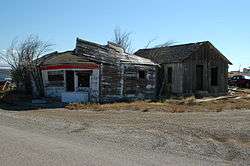
Buildings in Cisco | |
 Cisco  Cisco Location within the state of Utah | |
| Coordinates: 38°58′12″N 109°19′14″W / 38.97000°N 109.32056°WCoordinates: 38°58′12″N 109°19′14″W / 38.97000°N 109.32056°W | |
| Country | United States |
| State | Utah |
| County | Grand |
| Time zone | Mountain (MST) (UTC-7) |
| • Summer (DST) | MDT (UTC-6) |
Cisco is a ghost town in Grand County, Utah near the junction of State Route 128 and Interstate 70. The town started in the 1880s as a saloon and water-refilling station for the Denver and Rio Grande Western Railroad. As work crews and, later, travelers came through, stores, hotels and restaurants sprang up to accommodate them. Nearby cattle ranchers and sheep herders in the Book Cliffs north of town began using Cisco as a livestock and provisioning center. Around the turn of the 20th century, over 100,000 sheep were sheared at Cisco before being shipped to market. Then oil and natural gas were discovered. People began traveling more and Cisco continued to grow. Then the bottom fell out. The town's decline coincided with the demise of the steam locomotive. A declining economy crashed when Interstate-70 came through and bypassed Cisco altogether. [1]
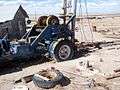
The town site contains many relics of a typical old west railroad town. Cisco survived long enough into the 20th century to be assigned a ZIP Code, 84515.[2] Unfortunately for history and railroad buffs, the ghost town's easy access and proximity to the freeway have lured vandals; the relics are heavily damaged and the town is littered with abandoned vehicles.
Mining
Oil and natural gas were discovered near Cisco in 1924. In 2005, new oil and gas wells were drilled in the nearby Cisco Oil Field by a Reno, Nevada-based company.[3] Newly drilled wells can be seen next to the railroad track and around the freeway.
Transportation
Cisco was formerly along the route of US-6/US-50. The town was bypassed with the completion of Interstate 70 through the area but is still accessible by way of exit 204. Cisco is listed as a control city for State Route 128, although the highway does not enter Cisco.[4] Cisco is still served by the Union Pacific Railroad where a rail siding remains in use. The California Zephyr passenger train passes through Cisco, but is not a scheduled stop. During the summer months, whitewater river rafters use Cisco as a landing site, particularly for a trip through Westwater Canyon. The Kokopelli mountain bike Trail passes through Cisco.[5]
A fiber switch has been installed at Cisco by Emery Telecom. DSL is now available at Cisco, provided by Emery Telecom.
Media and pop culture
- Johnny Cash wrote the song "Cisco Clifton's Fillin Station" about H. Ballard Harris, a man living in Cisco. His wife was named Maxine Harris. They owned a gas station/curio shop. In the 1980s, they were in their 70s.[6]
- "The Cisco Cliftons" band is composed of one of H. Ballard Harris's grandsons and was the inspiration for the band name.
- Cisco was a filming location for the movies Vanishing Point (1971) (the fictional/script location was Cisco, California), Thelma and Louise (1991), and Don't Come Knocking (2005). It was also filmed by the online group "The Creatures" during their "Road to E3" online special (2015).
-
Oil wells in Cisco
-

Cisco oil field
-
Cisco Yellow House with 1932 rig
-
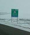
Exit sign on westbound Interstate 70
Climate
According to the Köppen Climate Classification system, Cisco has a semi-arid climate, abbreviated "BSk" on climate maps.[7]
References
- ↑ Nancy Hazelet {thanks to A.J. Rogers}. "Cisco - Utah Ghost Town". Atjeu LLC. Retrieved January 22, 2008.
- ↑ http://zip4.usps.com/zip4/citytown_zip.jsp USPS Zip Code locator
- ↑ Pacific Energy and Mining Cisco Project
- ↑ http://members.aol.com/utahhwys/rte070.htm Dan Stober's Utah Highways page (personal website) last accessed 08-26-2007
- ↑ "Kokopelli Trail". Blm.gov. 2016-04-15. Retrieved 2016-08-08.
- ↑ Comment from David Adamson, 2014, https://www.youtube.com/watch?v=f3qaAUrWJpQ
- ↑ "Cisco, Utah Köppen Climate Classification (Weatherbase)". Retrieved 8 August 2016.
External links
Municipalities and communities of Grand County, Utah, United States | ||
|---|---|---|
| City |  | |
| Town | ||
| CDP | ||
| Unincorporated community | ||
| Indian reservation | ||
| Ghost towns | ||
| Footnotes | ‡This populated place also has portions in an adjacent county or counties | |