Cison di Valmarino
| Cison di Valmarino | ||
|---|---|---|
| Comune | ||
| Comune di Cison di Valmarino | ||
|
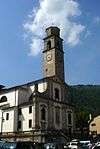
Cison village centre | ||
| ||
 Cison di Valmarino Location of Cison di Valmarino in Italy | ||
| Coordinates: 45°58′N 12°08′E / 45.967°N 12.133°E | ||
| Country | Italy | |
| Region | Veneto | |
| Province / Metropolitan city | Province of Treviso (TV) | |
| Government | ||
| • Mayor | Cristina Pin | |
| Area | ||
| • Total | 28 km2 (11 sq mi) | |
| Elevation | 261 m (856 ft) | |
| Population (1 June 2008) | ||
| • Total | 2,553 | |
| • Density | 91/km2 (240/sq mi) | |
| Demonym(s) | Cisonesi | |
| Time zone | CET (UTC+1) | |
| • Summer (DST) | CEST (UTC+2) | |
| Postal code | 31030 | |
| Dialing code | 0422 | |
| Patron saint | St. John the Baptist | |
| Saint day | 24 June | |

Cison di Valmarino is a village and comune with 2,553 inhabitants in the province of Treviso[1][2]
History
Prehistory
There is evidence that the area has been inhabited since prehistoric times from archaeological discoveries in Follina from the Paleolithic Mesolithic eras, to roof tiles and other fragments from the Bronze Age found in Valmareno
Ancient world
During the Roman period the Via Claudia Augusta a very important Roman road, which linked the valley of the Po River with Rhaetia (modern Austria) across the Alps, ran through this area.
Middle Ages
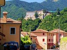
The area became an important defensive position against barbarian invasions during the European Migration Period, with the fortress of CastelBrando being expanded and refortified.
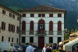
The 15th-century Villa Casagrande is now the home of Contessa Ghislaine Brandolini d’Adda.[3]
References
- ↑ Fonte: Istat - Unità amministrative, variazioni territoriali e di nome dal 1861 al 2000 - ISBN 88-458-0574-3
- ↑ Istituto Nazionale di Statistica
- ↑ "Casual cooking with an Italian countess".