Clermont, New York
| Clermont, New York | |
|---|---|
| Town | |
|
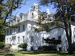
Clermont Manor | |
 Location of Clermont, New York | |
| Coordinates: 42°4′57″N 73°51′9″W / 42.08250°N 73.85250°W | |
| Country | United States |
| State | New York |
| County | Columbia |
| Government | |
| • Type | Town Council |
| • Town Supervisor | Raymond Staats (D) |
| • Town Council |
Members' List
|
| Area | |
| • Total | 19.2 sq mi (49.7 km2) |
| • Land | 18.0 sq mi (46.6 km2) |
| • Water | 1.2 sq mi (3.1 km2) |
| Elevation | 194 ft (59 m) |
| Population (2010) | |
| • Total | 1,965 |
| • Density | 109/sq mi (42.2/km2) |
| Time zone | Eastern (EST) (UTC-5) |
| • Summer (DST) | EDT (UTC-4) |
| ZIP code | 12526 |
| Area code(s) | 518 |
| FIPS code | 36-16177 |
| GNIS feature ID | 0978837 |
| Website |
clermontny |
Clermont /ˈklɛərˌmɒnt/ is a town in Columbia County, New York, United States. The population was 1,965 at the 2010 census.[1] The name of the town is French for "Clear Mountain", referring to the mountain views in the town.
The town is in the southwest corner of Columbia County, south of the city of Hudson.
History
"Clermont" was originally one of the oldest of the great estates of the mid-Hudson valley. The Clermont Manor was established in 1728, in what is now the town of Clermont. The manor was originally part of the 160,000-acre (650 km2) Livingston Manor; Clermont was a 13,000-acre (53 km2) section in the southwest corner that was bequeathed to Robert Livingston, a younger son. His descendants would come to own more than 500,000 acres (2,000 km2) in the Catskill Mountains and more than 100,000 acres (400 km2) in Dutchess County.
Clermont marked the northernmost penetration by British troops up the Hudson River during the American Revolution; Livingston's home was burned because of his prominent role in the Revolution. It was rebuilt between 1779 and 1782. The house is now a 500-acre (2.0 km2) New York State Historic Site and a National Historic Landmark.
In 1788, Clermont Manor was organized as the town of Clermont.
Clermont was the port of registry of Robert Fulton's first steamboat, co-owned by Livingston, which was called the North River. Today it is known as the Clermont. The ruins of its dock on the Hudson River can still be found at the historic site.
The estate, and later the town, was home to seven generations of the Livingston family until 1962.
The Bouwerie, Thomas Brodhead House, Clarkson Chapel, Clermont Academy, Clermont Civic Historic District, Coons House, Hickory Hill, Old Parsonagee, Sixteen Mile District, and St. Luke's Church are listed on the National Register of Historic Places.[2]
Geography
According to the United States Census Bureau, the town has a total area of 19.2 square miles (49.7 km2), of which 18.0 square miles (46.6 km2) is land and 1.2 square miles (3.1 km2), or 6.23%, is water.[1]
The south town line is the border of Dutchess County, and part of the west town line, marked by the Hudson River, is the border of Ulster County. The northeast border of the town follows the Roeliff Jansen Kill, a tributary of the Hudson River. The border formed by the kill is for much of its length quite close to the town's southern border and then its border with the town of Germantown to the west, resulting in long, narrow extensions of the town to the southeast and north.
Demographics
| Historical population | |||
|---|---|---|---|
| Census | Pop. | %± | |
| 1820 | 1,164 | — | |
| 1830 | 1,203 | 3.4% | |
| 1840 | 1,231 | 2.3% | |
| 1850 | 1,130 | −8.2% | |
| 1860 | 968 | −14.3% | |
| 1870 | 1,021 | 5.5% | |
| 1880 | 918 | −10.1% | |
| 1890 | 798 | −13.1% | |
| 1900 | 812 | 1.8% | |
| 1910 | 800 | −1.5% | |
| 1920 | 667 | −16.6% | |
| 1930 | 805 | 20.7% | |
| 1940 | 806 | 0.1% | |
| 1950 | 898 | 11.4% | |
| 1960 | 980 | 9.1% | |
| 1970 | 1,120 | 14.3% | |
| 1980 | 1,269 | 13.3% | |
| 1990 | 1,443 | 13.7% | |
| 2000 | 1,732 | 20.0% | |
| 2010 | 1,965 | 13.5% | |
| Est. 2014 | 1,946 | [3] | −1.0% |
As of the census[5] of 2000, there were 1,726 people, 593 households, and 437 families residing in the town. The population density was 96.0 people per square mile (37.0/km²). There were 725 housing units at an average density of 40.3 per square mile (15.6/km²). The racial makeup of the town was 96.58% White, 1.27% African American, 0.23% Native American, 0.35% Asian, 0.52% from other races, and 1.04% from two or more races. Hispanic or Latino of any race were 2.72% of the population.
There were 593 households out of which 36.9% had children under the age of 18 living with them, 57.3% were married couples living together, 11.8% had a female householder with no husband present, and 26.3% were non-families. 21.4% of all households were made up of individuals and 9.1% had someone living alone who was 65 years of age or older. The average household size was 2.85 and the average family size was 3.33.
In the town, the population was spread out with 30.3% under the age of 18, 7.2% from 18 to 24, 27.8% from 25 to 44, 22.9% from 45 to 64, and 11.8% who were 65 years of age or older. The median age was 36 years. For every 100 females, there were 96.4 males. For every 100 females age 18 and over, there were 91.0 males.
The median income for a household in the town was $47,039, and the median income for a family was $51,012. Males had a median income of $35,526 versus $26,250 for females. The per capita income for the town was $21,566. About 6.4% of families and 9.4% of the population were below the poverty line, including 8.7% of those under age 18 and 8.5% of those age 65 or over.
Communities and locations in Clermont
- Clermont – The hamlet of Clermont in the northeast part of the town.
- Clermont State Historic Site – A state and national historic site at the Hudson River, comprising the core of Clermont Manor.
- Cross Hill – A hamlet in the western part of town, east of the state historic site.
- Elizaville – A hamlet in the southeast corner of the town.
- Nevis – A hamlet south of Clermont on Route 9.
- Viewmont – A hamlet on the north town line, north of Cross Hill.
References
- 1 2 "Geographic Identifiers: 2010 Demographic Profile Data (G001): Clermont town, Columbia County, New York". U.S. Census Bureau, American Factfinder. Retrieved December 9, 2014.
- ↑ National Park Service (2010-07-09). "National Register Information System". National Register of Historic Places. National Park Service.
- ↑ "Annual Estimates of the Resident Population for Incorporated Places: April 1, 2010 to July 1, 2014". Retrieved June 4, 2015.
- ↑ "Census of Population and Housing". Census.gov. Archived from the original on May 11, 2015. Retrieved June 4, 2015.
- ↑ "American FactFinder". United States Census Bureau. Archived from the original on 2013-09-11. Retrieved 2008-01-31.
External links
| Wikimedia Commons has media related to Clermont, New York. |
Municipalities and communities of Columbia County, New York, United States | ||
|---|---|---|
| City | 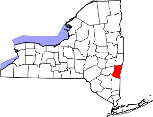 | |
| Towns | ||
| Villages | ||
| CDPs | ||
| Other hamlets | ||
| Footnotes | ‡This populated place also has portions in an adjacent county or counties | |
Coordinates: 42°05′06″N 73°49′37″W / 42.08500°N 73.82694°W