Climate of South Africa

The climate of South Africa is determined by South Africa's situation between 22°S and 35°S, in the Southern Hemisphere's subtropical zone, and its location between two oceans, Atlantic and Indian. It has a wider variety of climates than most other countries in sub-Saharan Africa, and it has lower average temperatures than other countries within this range of latitude, like Australia, because much of the interior (central plateau or Highveld, including Johannesburg) of South Africa is at higher elevation. Winter temperatures may reach the freezing point at high altitude, but are at their most mild in coastal regions, particularly the Eastern Cape. Cold and warm coastal currents running north-west and north-east respectively account for the difference in climated between west and east coasts. The weather is also influenced by ENSO (El Niño–Southern Oscillation).
South Africa experiences a high degree of sunshine with rainfall about half of the global average, increasing from west to east, and with semi-desert regions in the north-west. While the Western Cape has a Mediterranean climate with winter rainfall, most of the country experiences summer rainfall.
Temperature
South Africa has typical weather for the Southern Hemisphere, with the coldest days in June–August. On the central plateau, which includes the Free State and Gauteng provinces, the altitude keeps the average temperatures below 30 °C (86 °F); Johannesburg, for example, lies at 1,753 metres (5,751 ft). In winter temperatures can drop below freezing, also due to altitude. During winter it is warmest in the coastal regions, especially on the eastern Indian Ocean coast.
| City | Summer (January) | Winter (July) | ||
|---|---|---|---|---|
| Max | Min | Max | Min | |
| Bloemfontein | 31 | 15 | 17 | -2 |
| Cape Town | 26 | 16 | 18 | 7 |
| Durban | 28 | 21 | 23 | 11 |
| East London | 26 | 18 | 21 | 10 |
| George | 25 | 15 | 19 | 7 |
| Johannesburg | 26 | 15 | 20 | 4 |
| Kimberley | 33 | 18 | 19 | 3 |
| Mthatha | 27 | 16 | 21 | 4 |
| Musina | 34 | 21 | 25 | 7 |
| Nelspruit | 29 | 19 | 23 | 6 |
| Pietermaritzburg | 28 | 18 | 23 | 3 |
| Polokwane | 28 | 17 | 20 | 4 |
| Port Elizabeth | 25 | 18 | 20 | 9 |
| Pretoria | 29 | 18 | 24 | 5 |
| Richards Bay | 29 | 21 | 23 | 12 |
| Skukuza | 33 | 21 | 26 | 6 |
| Thohoyandou | 31 | 20 | 24 | 10 |
| Upington | 36 | 20 | 21 | 4 |
Precipitation
South Africa is a sunny country, averaging 8-10 daily sunshine hours in most regions.[2] The average annual rainfall for South Africa is 450mm (compared to a global average of 860mm) but large and unpredictable variations are common. Overall, rainfall is greatest in the east and gradually decreases westward, with some semi-desert areas along the western edge of South Africa. For most of the country, rain falls mainly in the summer months with brief afternoon thunderstorms. The exception is the Western Cape and its capital city Cape Town where the climate is Mediterranean and it rains more in the wintertime.[3]In the winter months, snow collects on the high mountains of the Cape and the Drakensberg.
Oceans
South Africa's coasts are major tourist attractions and trade locations. This makes the ocean important to South Africa and its citizens. The Indian and Atlantic oceans meet at the southwestern tip of South Africa. The warm Agulhas Current runs south along the east coast and the cold Benguela Current flows north along the western shore. As a result, there is at least a 6 °C difference in the annual temperatures of Durban (on the east) and Port Nolloth (on the west) despite being located at roughly the same latitude.[3]
ENSO
Warm season weather is influenced by the Southern Oscillation (ENSO, or El Niño–Southern Oscillation). South Africa experiences hotter and drier weather during the El Niño phase while La Niña brings cooler and wetter conditions.
Climatic zones
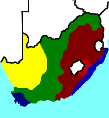
Climatic zones are often referred to by the seasonal pattern of rainfall (Summer rainfall region, Winter rainfall region, Summer and winter rainfall region, and the Arid region), as shown in Figure 2. The winter rainfall region is confined to a relatively small area in the south-west, the Western Cape area, where gentle rain falls from May to August but the summers are dry. The summer rainfall region is the largest, being most of the country north of the coastal areas and the north west arid desert. Rain fall from October to February amd is often heavy, with the amount of precipitation increasing from west to east. The summer and winter rainfall region is the Eastern Cape. The arid regions are in the north-west, with the dryest areas being the north-west coast. Vegetation tends to vary by climatic zone,[4] and these also correspond to the horticultural zones.[5]
Highveld
The Highveld is the eastern plateau area of South Africa. It is typified by Johannesburg, at an elevation of 1,753 metres (5,751 ft). The former CBD is found on the south side of the prominent ridge called the Witwatersrand (Afrikaans: White Water's Ridge) and the terrain falls to the north and south. By and large the Witwatersrand marks the watershed between the Limpopo and Vaal rivers. The north and west of the city has undulating hills while the eastern parts are flatter.
The city enjoys a dry, sunny climate, with the exception of occasional late afternoon downpours in the summer months of October to April. Temperatures in Johannesburg are usually fairly mild due to the city's high altitude, with the average maximum daytime temperature in January of 26 °C (78.8 °F), dropping to an average maximum of around 16 °C (60.8 °F) in June. Winter is the sunniest time of the year, with cool days and cold nights. The temperature occasionally drops to below freezing at night, causing frost. Snow is a rare occurrence, with snowfall having been experienced in May 1956, August 1962, June 1964, September 1981, August 2006 (light), on 27 June 2007,[6] accumulating up to 10 centimetres (3.9 in) in the southern suburbs, and most recently on 7 August 2012.
Regular cold fronts pass over in winter bringing very cold southerly winds but usually clear skies. The annual average rainfall is 713 millimetres (28.1 in), which is mostly concentrated in the summer months. Infrequent showers occur through the course of the winter months.
Mediterranean
The Western Cape province has a Mediterranean climate with warm to hot, dry, sunny summer weather and mild, rainy conditions in winter.
References
- ↑ "South Africa's weather and climate". SouthAfrica.info. Retrieved 23 February 2014.
- ↑ "South Africa". BBC Weather. Retrieved 23 February 2014.
- 1 2 SAG 2016.
- ↑ Rainfall regions 2016.
- ↑ PlantZAfrica 2016, Horticultural Zones
- ↑ SABCnews.com. "Joburg covered by snow as temperature drops". Archived from the original on 29 June 2007. Retrieved 2007-07-16.
Bibliography
- "Geography and climate". About SA. South African Government. 2016. Retrieved 19 November 2016.
- "Land and its people: Climate" (PDF). South Africa Yearbook 2014/15. South African Government. 2016. Retrieved 20 November 2016.
- "Rainfall Regions in South Africa" (PDF). Grade 5 Geography. Retrieved 20 November 2016.
- "PlantZAfrica". SANBI. Retrieved 14 November 2016.