Clinton-Sherman Industrial Airpark
Coordinates: 35°20′23″N 099°12′02″W / 35.33972°N 99.20056°W
| Clinton-Sherman Industrial Airpark | |||||||||||||||
|---|---|---|---|---|---|---|---|---|---|---|---|---|---|---|---|
 | |||||||||||||||
|
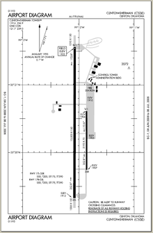
Airfield diagram from Federal Aviation Administration | |||||||||||||||
| IATA: CSM – ICAO: KCSM – FAA LID: CSM | |||||||||||||||
| Summary | |||||||||||||||
| Airport type | Public | ||||||||||||||
| Owner | Oklahoma Space Industry Development Authority | ||||||||||||||
| Serves | Clinton, Oklahoma | ||||||||||||||
| Location | Burns Flat, Oklahoma | ||||||||||||||
| Elevation AMSL | 1,922 ft / 586 m | ||||||||||||||
| Runways | |||||||||||||||
| |||||||||||||||
| Statistics (2006) | |||||||||||||||
| |||||||||||||||
- For the military use of the facility before 1969 see Clinton-Sherman Air Force Base
The Clinton-Sherman Industrial Airpark, also known as the Oklahoma Air & Space Port is a spaceport near Burns Flat, Oklahoma, in the western part of the state.[2] The Federal Aviation Administration (FAA) granted a license to the site in June 2006 to the Oklahoma Space Industry Development Authority (OSIDA) to "oversee the takeoff and landing of suborbital, reusable launch vehicles".[2] The license expires in five years and requires regular safety inspections by the FAA. Individual operators must also secure a separate license in order to make space flights from the facility.
Facilities
The airpark is at the site of a public airfield known as Clinton-Sherman Airport (IATA: CSM, ICAO: KCSM). The airport covers an area of 1,690 acres (680 ha) which contains two concrete paved runways: 17R/35L measuring 13,503 x 150 ft (46 m). and 17L/35R measuring 5,193 x 75 ft. (1,583 x 23 m). The longer of these, at 13,503 x 150 ft (4,116 x 46 m) is a major benefit for use as a spaceport.
For the 12-month period ending May 2, 2006, the airport had 49,500 aircraft operations, an average of 135 per day: 98% military and 2% general aviation.[1]
The location is a 2,700 acre (10.8 km²) facility located near transportation corridors such as Interstate 35 and Interstate 40. There are 96 acres (384,000 m²) of parking space able to support large commercial aircraft. There are six commercial aircraft hangars and a 50,000 square-foot (4,500 m²) manufacturing facility with loading docks adjacent to a railway spur.[3]
History
The facility operated for a number years as part of the United States Navy and United States Air Force. Closed under the name Clinton-Sherman Air Force Base, the facility has been redeveloped over the years to its present form.
The location of the former naval air station World War II runways to the north and west of the main runway are still visible on aerial photographs of the airport; however they are not usable.
Operations
One company, Rocketplane Kistler, formerly based in Oklahoma, had plans to build a spacecraft and, as of 2006, had plans to offer commercial space flights from the Oklahoma Spaceport by 2009.[4]
Armadillo Aerospace conducted flight test Activities at the Oklahoma Spaceport in 2004 through 2009, including tests of a VTVL Lander and a Rocket Racer for the Rocket Racing League.
The former northeast 'alert pads' and ready facility of the former Strategic Air Command base currently houses the Law Enforcement Driver Training Center of the Oklahoma Highway Patrol, Oklahoma Department of Public Safety. Currently referred to as 'Building 120', the former bunker facility houses OHP Academy staff and cadets during the driving training portion of 'Patrol Schools'. The annual 'Cadet Lawman Academy' (sponsored by the OSTA, Elks Lodge, and C.U.D.D.), is also located at the same facility during the summer, which provides a 1-week program for high school students. The surrounding facility and tarmac incorporates over 12 miles of various roadways and courses, used for precision driving and emergency vehicle operation training. This facility is recognized as one of the top ranked law enforcement driver training centers in the country, according to the Federal Law Enforcement Training Center.
References
- 1 2 FAA Airport Master Record for CSM (Form 5010 PDF), effective 2007-10-25
- 1 2 Murphy, Sean (14 June 2006). "FAA issues Oklahoma spaceport license". The Mercury News. Retrieved 2006-06-26.
- ↑ "Wide, Open Space Dedicated to the Aerospace Industries of the Future!". Oklahoma Space Industry Development Authority. Retrieved 2006-06-26.
- ↑ Foust, Jeff (2009-07-31). "Rocketplane's woes". Personal Spaceflight. Retrieved 2009-09-07.
External links
| Wikimedia Commons has media related to Clinton-Sherman Industrial Airpark. |
- Oklahoma Space Industry Development Authority
- FAA Airport Diagram (PDF), effective December 8, 2016
- Resources for this airport:
- FAA airport information for CSM
- AirNav airport information for KCSM
- ASN accident history for CSM
- FlightAware airport information and live flight tracker
- NOAA/NWS latest weather observations
- SkyVector aeronautical chart, Terminal Procedures
