Cloondara
| Cloondara Cluain Dá Ráth | |
|---|---|
| Town | |
 | |
 Cloondara Location in Ireland | |
| Coordinates: 53°44′00″N 7°54′30″W / 53.73322°N 7.908343°WCoordinates: 53°44′00″N 7°54′30″W / 53.73322°N 7.908343°W | |
| Country | Ireland |
| Province | Leinster |
| County | County Longford |
| Time zone | WET (UTC+0) |
| • Summer (DST) | IST (WEST) (UTC-1) |
| Irish Grid Reference | xxx |
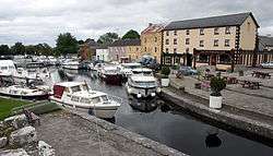
Cloondara (Irish: Cluain Dá Ráth, meaning "pasture of two ringforts")[1][2] is a small village in County Longford, Ireland. It is situated just off the N5 road near Termonbarry, where the Royal Canal terminates at the River Shannon. It lies 7 km (4.3 mi) west of Longford Town. The Royal Canal is being upgraded so that canal boats can once again travel along it. The village of Termonbarry lies to the west of the village, on the opposite bank of the river Shannon. Many residential properties are being built, due to the tax incentives available in the area.
See also
References
- ↑ A. D. Mills, 2003, A Dictionary of British Place-Names, Oxford University Press
- ↑ Placenames Database of Ireland
This article is issued from Wikipedia - version of the 8/14/2016. The text is available under the Creative Commons Attribution/Share Alike but additional terms may apply for the media files.