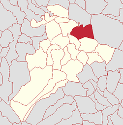
Clooney, Kilcronaghan civil parish
| Clooney | |
|---|---|
| Irish transcription(s) | |
| • Derivation: | An Chluanaidh |
| • Meaning: | "The meadow" |
 | |
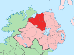
 Clooney Clooney shown within Northern Ireland | |
| Coordinates: 54°48′36″N 6°41′13″W / 54.810°N 6.687°WCoordinates: 54°48′36″N 6°41′13″W / 54.810°N 6.687°W | |
| Country | Northern Ireland |
| County | County Londonderry |
| Barony | Loughinsholin |
| Civil parish | Kilcronaghan |
| Plantation grant | Drapers Company and freeholds |
| First recorded | 1609 |
| Government | |
| • Council | Magherafelt District Council |
| • Ward | Tobermore |
| Area[1] | |
| • Total | 161.33 ha (398.65 acres) |
| Irish grid ref | H8496 |
Clooney (locally [ˌkloːni] and [ˌkloni], from Irish: An Chluanaidh, meaning "the meadow"[2]) is a townland lying within the civil parish of Kilcronaghan, County Londonderry, Northern Ireland. It lies in north-east of the parish and is bounded in the north by the Moyola River as well as the parish of Termoneeny. It is bounded by the following townlands; Ballynahone Beg, Ballynahone More, Gortamney, Moyesset, and Tobermore. It was apportioned to the Drapers company as well as freeholds.[3]
The townland is currently part of Tobermore electoral ward of Magherafelt District Council, however in 1926 it was part of Tobermore district electoral division as part of the Maghera division of Magherafelt Rural District.[4] It was also part of the historic barony of Loughinsholin.[3]
History
John O'Donovan, who worked on the Ordnance Survey if the early 19th century, recommended that the townland of Clooney be spelt as "Cloan", however his suggestion was scored out in the Ordnance Survery Name Books and replaced with "Cloney", which was based on the apparent usage of the time. At a later stage it was again revised to the modern spelling "Clooney".[2]
The townland appears to have been originally known along the lines oBallynecloney (from Irish: Baile na Cluana, meaning "townland of the meadow"), with variations of this spelling used in various sources from 1609 until 1657.[2]
|
|
| ||||||||||||||||||||||||||||||||||||||||||||||
See also
References
- ↑ Northern Ireland Environment Agency. "NIEA Map Viewer". Retrieved 27 January 2012.
- 1 2 3 4 Toner, Gregory: Place-Names of Northern Ireland, page 117. Queen's University of Belfast, 1996, ISBN 0-85389-613-5
- 1 2 Notes on the Place Names of the Parishes and Townlands of the County of Londonderry, 1925, Alfred Moore Munn, Clerk of the Crown and Peace of the City and County of Londonderry
- 1 2 3 4 HistPop; County and County Borough of Londonderry, 1926, page 27
- 1 2 3 4 5 6 HistPop; Area, population and number of houses, Vol. III, Ireland, 1881, page 698
- ↑ HistPop; County of Londonderry, 1851, page 241
- ↑ Place Names NI - Clooney