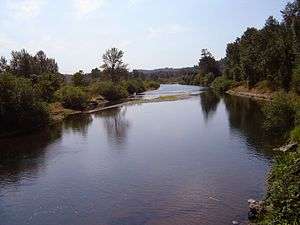
Coast Fork Willamette River
| Coast Fork Willamette River | |
 The Coast Fork Willamette River | |
| Name origin: Willamette is from a similar Clackamas Indian village name[1] | |
| Country | United States |
|---|---|
| State | Oregon |
| County | Lane |
| Tributaries | |
| - right | Row River |
| Source | Confluence of Big River and Garoutte Creek |
| - location | Calapooya Mountains, Oregon |
| - elevation | 990 ft (302 m) [2] |
| - coordinates | 43°35′44″N 123°4′4″W / 43.59556°N 123.06778°W [3] |
| Mouth | Willamette River |
| - location | near Eugene and Springfield, Oregon |
| - elevation | 436 ft (133 m) [3] |
| - coordinates | 44°1′23″N 123°1′25″W / 44.02306°N 123.02361°WCoordinates: 44°1′23″N 123°1′25″W / 44.02306°N 123.02361°W [3] |
| Length | 40 mi (64 km) [4] |
| Basin | 666 sq mi (1,725 km2) [5] |
| Discharge | for Goshen, 6.4 miles (10.3 km) from the mouth |
| - average | 1,558 cu ft/s (44 m3/s) [6] |
| - max | 58,500 cu ft/s (1,657 m3/s) |
| - min | 36 cu ft/s (1 m3/s) |
 Map of the Willamette River basin with the Coast Fork highlighted
| |
 Location of the mouth of the Coast Fork Willamette River in Oregon
| |
The Coast Fork Willamette River is one of two forks that unite to form the Willamette River in western Oregon in the United States. It is about 40 miles (64 km) long, draining an area of the mountains at the south end of the Willamette Valley south of Eugene.
Course
The Coast Fork Willamette River is formed in southwestern Lane County, in the Calapooya Mountains, by the confluence of the Little River and the Big River. The Coast Fork flows north through the mountains, through the Cottage Grove Lake reservoir, to Cottage Grove, where it receives the Row River from the southeast. It continues north past Creswell and joins the Middle Fork from the south, about 2 miles (3 km) southeast of Eugene, to form the Willamette.
See also
References
- ↑ Bright, William (2004). Native American Placenames of the United States. Norman, Oklahoma: University of Oklahoma Press. p. 567. ISBN 978-0-8061-3598-4.
- ↑ Source elevation derived from Google Earth search using GNIS source coordinates.
- 1 2 3 "Coast Fork Willamette River". Geographic Names Information System (GNIS). United States Geological Survey. November 28, 1980. Retrieved August 4, 2010.
- ↑ United States Geological Survey (USGS). "United States Geological Survey Topographic Map: Harness Mountain, Oregon, Quadrant". TopoQuest. Retrieved August 3, 2010. The map includes river-mile markers from mouth to source.
- ↑ "Coast Fork Willamette". Willamette Riverkeeper. Retrieved August 4, 2010.
- ↑ "Water-data report 2009: 14157500 Coast Fork Willamette River near Goshen, OR" (pdf). United States Geological Survey. Retrieved April 22, 2011.
External links
-
 Media related to Coast Fork Willamette River at Wikimedia Commons
This article is issued from Wikipedia - version of the 9/11/2016. The text is available under the Creative Commons Attribution/Share Alike but additional terms may apply for the media files.