Cottage Grove, Oregon
| Cottage Grove, Oregon | ||
|---|---|---|
| City | ||
|
Cottage Grove Historic District | ||
| ||
| Nickname(s): Covered Bridge Capital of Oregon | ||
 Location in Oregon | ||
| Coordinates: 43°47′41″N 123°3′9″W / 43.79472°N 123.05250°WCoordinates: 43°47′41″N 123°3′9″W / 43.79472°N 123.05250°W | ||
| Country | United States | |
| State | Oregon | |
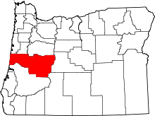
| County | Lane | |
| Incorporated | 1887 | |
| Government | ||
| • Type | Council-manager | |
| • City Manager | Richard Meyers | |
| • Mayor | Tom Munroe (D)[1] | |
| Area[2] | ||
| • Total | 3.77 sq mi (9.76 km2) | |
| • Land | 3.76 sq mi (9.74 km2) | |
| • Water | 0.01 sq mi (0.03 km2) | |
| Elevation | 640 ft (195 m) | |
| Population (2010)[3] | ||
| • Total | 9,686 | |
| • Estimate (2012[4]) | 9,770 | |
| • Density | 2,576.1/sq mi (994.6/km2) | |
| Time zone | Pacific (UTC-8) | |
| • Summer (DST) | Pacific (UTC-7) | |
| ZIP codes | 97424, 97472 | |
| Area code(s) | 541 | |
| FIPS code | 41-15950[5] | |
| GNIS feature ID | 1166636[6] | |
| Website | www.cottagegrove.org | |


Cottage Grove is a city in Lane County, Oregon, United States. The population was 9,686 at the 2010 census.[7] Cottage Grove is the third largest city in Lane County. The city is located on Interstate 5, Oregon Route 99, and the main Willamette Valley line of the Union Pacific railroad.[8]
History
Cottage Grove post office was established in 1855 east of present-day Creswell.[9] The office was named by its first postmaster, G. C. Pearce, whose home was in an oak grove.[9] In 1861, the office was moved to the present site of Saginaw.[9] In the late 1860s, the office was moved to what is now the extreme southwestern part of present-day Cottage Grove, on the west bank of the Coast Fork Willamette River.[9] When the Southern Pacific railroad was built through the area in the 1870s, Cottage Grove station was placed more than half a mile northeast of the post office, on the east side of the river.[9][10] This was the start of a neighborhood dispute that lasted for nearly 20 years.[9] The people living near the post office did not want it moved to the railroad station, so a new office was established at the station with the name Lemati, which is a Chinook Jargon word that means "mountain".[9] Lemati office ran from November 1893 to September 1894, but in March 1898 the Cottage Grove office was renamed Lemati and it ran that way until being permanently renamed Cottage Grove in May 1898.[9]
The city was incorporated in 1887, but the people living on the east side rebelled in 1893 and founded East Cottage Grove.[9] The Oregon State Legislature changed the name of the place to Lemati in 1895, and the signboard for the station listed Cottage Grove, as well as Lemati in smaller letters.[9] In 1899 an act was passed that consolidated the two towns under the name Cottage Grove.[9]
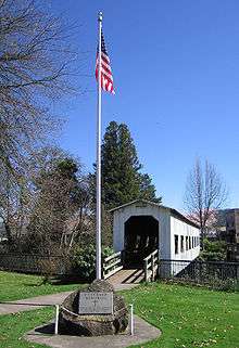
The only existing covered railroad bridge west of the Mississippi River, the National Register of Historic Places-listed Chambers Railroad Bridge, is in Cottage Grove. The City of Cottage Grove restored the bridge in 2011, reopening it on December 3.[11]
Cottage Grove has been awarded the All-America City Award by the National Civic League twice, in 1968 and 2004.[12] Cottage Grove has been recognized as a Tree City USA by The Arbor Day Foundation for over a decade.[13] In October 2008, Cottage Grove was also the 17th city in the United States to be recognized as a Green Power Community.[14]
Geography
According to the United States Census Bureau, the city has a total area of 3.77 square miles (9.76 km2), of which, 3.76 square miles (9.74 km2) is land and 0.01 square miles (0.03 km2) is water.[2]
Cottage Grove lies south of the confluence of the Row River and the Coast Fork Willamette River.[8] This confluence effectively marks the southern end of the Willamette Valley.
Climate
This region experiences warm (but not hot) and dry summers, with no average monthly temperatures above 71.6 °F (22.0 °C). According to the Köppen Climate Classification system, Cottage Grove has a warm-summer Mediterranean climate, abbreviated "Csb" on climate maps.[15]
| Climate data for Cottage Grove | |||||||||||||
|---|---|---|---|---|---|---|---|---|---|---|---|---|---|
| Month | Jan | Feb | Mar | Apr | May | Jun | Jul | Aug | Sep | Oct | Nov | Dec | Year |
| Record high °F (°C) | 68 (20) |
76 (24) |
87 (31) |
87 (31) |
98 (37) |
101 (38) |
105 (41) |
105 (41) |
105 (41) |
96 (36) |
76 (24) |
73 (23) |
105 (41) |
| Average high °F (°C) | 47.3 (8.5) |
51.9 (11.1) |
56.2 (13.4) |
61.4 (16.3) |
67.7 (19.8) |
73.8 (23.2) |
81.6 (27.6) |
81.9 (27.7) |
76.1 (24.5) |
64.9 (18.3) |
53.5 (11.9) |
47.5 (8.6) |
63.7 (17.6) |
| Average low °F (°C) | 33 (1) |
34.3 (1.3) |
35.8 (2.1) |
38 (3) |
42.1 (5.6) |
46.5 (8.1) |
48.7 (9.3) |
48.3 (9.1) |
45 (7) |
41.5 (5.3) |
37.5 (3.1) |
34.1 (1.2) |
40.4 (4.7) |
| Record low °F (°C) | −2 (−19) |
0 (−18) |
14 (−10) |
21 (−6) |
23 (−5) |
29 (−2) |
23 (−5) |
32 (0) |
24 (−4) |
17 (−8) |
9 (−13) |
−7 (−22) |
−7 (−22) |
| Average precipitation inches (mm) | 6.73 (170.9) |
5.17 (131.3) |
5.21 (132.3) |
3.61 (91.7) |
2.6 (66) |
1.57 (39.9) |
0.4 (10) |
0.67 (17) |
1.51 (38.4) |
3.67 (93.2) |
6.92 (175.8) |
7.37 (187.2) |
45.43 (1,153.9) |
| Average snowfall inches (cm) | 2.9 (7.4) |
0.9 (2.3) |
0.8 (2) |
0.1 (0.3) |
0 (0) |
0 (0) |
0 (0) |
0 (0) |
0 (0) |
0 (0) |
0.2 (0.5) |
1.1 (2.8) |
5.9 (15) |
| Average precipitation days | 19 | 16 | 18 | 15 | 12 | 8 | 2 | 3 | 6 | 12 | 17 | 19 | 147 |
| Source: [16] | |||||||||||||
Demographics
| Historical population | |||
|---|---|---|---|
| Census | Pop. | %± | |
| 1900 | 974 | — | |
| 1910 | 1,834 | 88.3% | |
| 1920 | 1,919 | 4.6% | |
| 1930 | 2,473 | 28.9% | |
| 1940 | 2,626 | 6.2% | |
| 1950 | 3,536 | 34.7% | |
| 1960 | 3,895 | 10.2% | |
| 1970 | 6,004 | 54.1% | |
| 1980 | 7,148 | 19.1% | |
| 1990 | 7,402 | 3.6% | |
| 2000 | 8,432 | 13.9% | |
| 2010 | 9,686 | 14.9% | |
| Est. 2015 | 9,969 | [17] | 2.9% |
2010 census
As of the census[3] of 2010, there were 9,686 people, 3,895 households, and 2,469 families residing in the city. The population density was 2,576.1 inhabitants per square mile (994.6/km2). There were 4,154 housing units at an average density of 1,104.8 per square mile (426.6/km2). The racial makeup of the city was 90.4% White, 0.3% African American, 1.3% Native American, 1.1% Asian, 0.1% Pacific Islander, 3.1% from other races, and 3.8% from two or more races. Hispanic or Latino of any race were 8.0% of the population.
There were 3,895 households of which 32.2% had children under the age of 18 living with them, 43.8% were married couples living together, 14.8% had a female householder with no husband present, 4.9% had a male householder with no wife present, and 36.6% were non-families. 29.9% of all households were made up of individuals and 14.1% had someone living alone who was 65 years of age or older. The average household size was 2.47 and the average family size was 3.02.
The median age in the city was 38.3 years. 24.4% of residents were under the age of 18; 8.5% were between the ages of 18 and 24; 25.1% were from 25 to 44; 25.3% were from 45 to 64; and 16.5% were 65 years of age or older. The gender makeup of the city was 48.0% male and 52.0% female.
2000 census
As of the census[5] of 2000, there were 8,445 people, 3,264 households, and 2,183 families residing in the city. The population density was 2,561.6 people per square mile (988.1/km²). There were 3,430 housing units at an average density of 1,040.4 per square mile (401.3/km²). The racial makeup of the city was 92.84% White, 0.15% African American, 1.21% Native American, 0.92% Asian, 0.09% Pacific Islander, 1.55% from other races, and 3.23% from two or more races. Hispanic or Latino of any race were 4.94% of the population. There were 3,264 households out of which 33.0% had children under the age of 18 living with them, 49.4% were married couples living together, 13.2% had a female householder with no husband present, and 33.1% were non-families. 28.1% of all households were made up of individuals and 14.3% had someone living alone who was 65 years of age or older. The average household size was 2.54 and the average family size was 3.05.
In the city the population dispersal was 27.4% under the age of 18, 8.5% from 18 to 24, 26.4% from 25 to 44, 21.7% from 45 to 64, and 16.0% who were 65 years of age or older. The median age was 37 years. For every 100 females there were 92.1 males. For every 100 females age 18 and over, there were 86.5 males. The median income for a household in the city was $30,442, and the median income for a family was $37,457. Males had a median income of $30,775 versus $23,485 for females. The per capita income for the city was $14,550. About 15.6% of families and 19.8% of the population were below the poverty line, including 29.0% of those under age 18 and 13.0% of those age 65 or over.
Arts and culture
Annual cultural events
Two of the largest festivals in Cottage Grove are Bohemia Mining Days and the Covered Bridge Festival.[19]
Museums and other points of interest
Cottage Grove is known as the "Covered Bridge Capital of Oregon" with six covered bridges near the city.[20] Five of the six bridges, Chambers Covered Bridge, Currin Bridge, Dorena Bridge, Mosby Creek Bridge, and Stewart Bridge, are listed on the National Register of Historic Places. Centennial Covered Bridge is a replica bridge constructed from materials salvaged from dismantled bridges. The Swinging Bridge is a historic suspension footbridge.[21]
The city is also home to 21 murals located throughout downtown that reflect the history of the community. The Cottage Theatre is located in the city.
The Bohemia Gold Mining Museum features the area's gold mining history in the nearby Bohemia mining district.[22]
Film location
.jpg)
Several films have been filmed in Cottage Grove. In 1926, Buster Keaton's The General was filmed in Cottage Grove and the surrounding countryside.[23] The movie included a spectacular locomotive crash, and the wrecked train became a minor tourist attraction until it was dismantled for scrap during World War II.[24] The 1973 movie Emperor of the North Pole was filmed in and around Cottage Grove, as were parts of the 1978 movie Animal House.[25] The 25th anniversary of Animal House's release was celebrated by the citizens with a toga party on August 30, 2003, on Main Street. Main Street is where the climactic parade sequence from the movie was filmed. Portions of the movie Stand By Me were filmed along the railroad tracks east of Cottage Grove, which are now the Row River National Recreation Trail, a bicycle and walking trail.[20] Ricochet River, starring Kate Hudson, was filmed in Cottage Grove in 1997.[26]
Sports
Cottage Grove has two golf courses: Middlefield and Hidden Valley.
Parks and recreation
Dorena Lake and Cottage Grove Lake are near the city. There is also a system of cycle trails at Mosby Creek.
Education
The South Lane School District serves Cottage Grove and the surrounding area. Cottage Grove High School, Al Kennedy Alternative High School, Lincoln Middle School, Bohemia and Harrison elementary schools and the Academy for Character Education are located within the city. Lane Community College has a Cottage Grove satellite campus that offers both credit and enrichment courses.
Media
The Cottage Grove Sentinel, with a circulation of 3,331, is the city's weekly newspaper.[27] KNND is the local radio station.
Cottage Grove has been used as a filming location for movies, including 1978's National Lampoon's Animal House for the final parade scene, and Buster Keaton's The General.
Infrastructure
Transportation
- Air
Jim Wright Field is a public airport serving small general aviation aircraft, located one mile (1.6 km) east of Cottage Grove.
- Bus
Lane Transit District runs a bus service to nearby Eugene/Springfield. South Lane Wheels runs shuttle service in downtown Cottage Grove.
Notable people
See also
References
- ↑ "Thomas Munroe". Democratic Party of Oregon. Retrieved 2 October 2015.
- 1 2 "US Gazetteer files 2010". United States Census Bureau. Archived from the original on 2012-07-14. Retrieved 2012-12-21.
- 1 2 "American FactFinder". United States Census Bureau. Retrieved 2012-12-21.
- ↑ "Population Estimates". United States Census Bureau. Archived from the original on 2013-06-17. Retrieved 2013-06-02.
- 1 2 "American FactFinder". United States Census Bureau. Archived from the original on 2013-09-11. Retrieved 2008-01-31.
- ↑ "US Board on Geographic Names". United States Geological Survey. 2007-10-25. Retrieved 2008-01-31.
- ↑ "Race, Hispanic or Latino, Age, and Housing Occupancy: 2010 Census Redistricting Data (Public Law 94-171) Summary File (QT-PL), Cottage Grove city, Oregon". U.S. Census Bureau, American FactFinder 2. Archived from the original on September 11, 2013. Retrieved October 31, 2011.
- 1 2 Oregon Atlas & Gazetteer (7th ed.). Yarmouth, Maine: DeLorme. 2008. p. 47. ISBN 0-89933-347-8.
- 1 2 3 4 5 6 7 8 9 10 11 McArthur, Lewis A.; McArthur, Lewis L. (2003) [1928]. Oregon Geographic Names (7th ed.). Portland, Oregon: Oregon Historical Society Press. p. 235–236. ISBN 978-0875952772.
- ↑ "Cottage Grove Post Office". Geographic Names Information System. United States Geological Survey. August 1, 1994. Retrieved March 15, 2012.
- ↑ "Chambers Covered Railroad Bridge". City of Cottage Grove, Oregon. Archived from the original on 2012-05-13. Retrieved 2012-04-07.
- ↑ "Past Winners of the All-America City Award". All-America City Award. Retrieved 2012-04-07.
- ↑ "2010 Tree Cities USA Communities in Oregon". Arbor Day Foundation. Retrieved 2012-04-07.
- ↑ Tucker, Eric R. (2008-10-15). "How Green it is!". Cottage Grove Sentinel. News Media Corporation.
- ↑ Climate Summary for Cottage Grove, Oregon
- ↑ "COTTAGE GROVE, OR (351897)". Western Regional Climate Center. Retrieved November 22, 2015.
- ↑ "Annual Estimates of the Resident Population for Incorporated Places: April 1, 2010 to July 1, 2015". Retrieved July 2, 2016.
- ↑ "Census of Population and Housing". Census.gov. Archived from the original on May 11, 2015. Retrieved June 4, 2015.
- ↑ "Calendar of Events & Festivals | Cottage Grove | Eugene, Cascades & Oregon Coast". Eugenecascadescoast.org. Retrieved 2012-03-15.
- 1 2 "Community Attractions". Cottage Grove Area Chamber of Commerce. Retrieved 2012-04-07.
- ↑ Covered bridge tour brochure
- ↑ "Eugene, Cascades & Oregon Coast Visitor Information | Travel Lane County Oregon". Eugenecascadescoast.org. Retrieved 2012-03-15.
- ↑ John Bengton, How Buster Keaton Filmed The General, Accessed September 20, 2016
- ↑ Davis, Lon (2010-08-02). "Saluting The General in Cottage Grove". Classic Images. Lee Enterprises.
- ↑ "Cottage Grove Historical Society". CottageGroveHistoricalSociety.com. Retrieved 2012-04-07.
- ↑ "Oregon Movie Chronology, 1969-Present". Oregon Blue Book. Oregon Secretary of State. Retrieved 2012-04-07.
- ↑ "Cottage Grove Sentinel". Oregon Newspaper Publishers Association. Retrieved 2011-02-20.
External links
| Wikimedia Commons has media related to Cottage Grove, Oregon. |
| Wikivoyage has a travel guide for Cottage Grove. |
- Entry for Cottage Grove in the Oregon Blue Book
- Cottage Grove in the Oral History Archive