Coleman, Ontario
| Coleman | |
|---|---|
| Township (single-tier) | |
| Township of Coleman | |
|
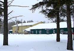
Municipal building | |
| Motto: Over 2 billion square feet of opportunity! | |
 Coleman | |
| Coordinates: 47°23′N 79°46′W / 47.383°N 79.767°WCoordinates: 47°23′N 79°46′W / 47.383°N 79.767°W | |
| Country |
|
| Province |
|
| District | Timiskaming |
| Incorporated | 1906 |
| Government | |
| • Type | Township |
| • Mayor | Dan Cleroux |
| • Federal riding | Nipissing—Timiskaming |
| • Prov. riding | Timiskaming—Cochrane |
| Area[1] | |
| • Land | 178.82 km2 (69.04 sq mi) |
| Population (2011)[1] | |
| • Total | 597 |
| • Density | 3.3/km2 (9/sq mi) |
| Time zone | EST (UTC-5) |
| • Summer (DST) | EDT (UTC-4) |
| Postal Code | P0J 1C0 |
| Area code(s) | 705 |
| Website | www.colemantownship.ca |
Coleman is a township in the northeastern part of the Canadian province of Ontario. It is situated in the Timiskaming District of Northern Ontario. The township had a population of 597 in the Canada 2011 Census.
It is located along Highway 11 and 11-B.
History
The community was first formed around 1906. The township is named after geologist A. P. Coleman who did extensive work in the region in the late 1800s. Coleman also mapped the Sudbury Basin leading to important nickel discoveries, and proved conclusively that the area had been repeatedly glaciated. The township celebrated its first 100 years in 2006.
Demographics
In the Canada 2011 Census, the township has a land area of 178.82 square kilometres and a population density of 3.3 persons per square kilometre. The number of private dwellings occupied by usual residents is 252 (total dwellings: 325).[1] The median age of the population is 47.6 years of age.[2]
Mother tongue:[2]
- English as first language: 77.0%
- French as first language: 14.9%
- English and French as first language: 4.6%
- Other as first language: 3.5%
Population trend:[3]
- Population in 2011: 597
- Population in 2006: 580
- Population in 2001: 550
- Population in 1996: 499 (or 534 when adjusted to 2001 boundaries)
- Population in 1991: 470
See also
References
External links
 |
Temiskaming Shores | Cobalt | | |
| Unorganized West Timiskaming | |
Unorganized West Timiskaming | ||
| ||||
| | ||||
| Latchford |
| City | 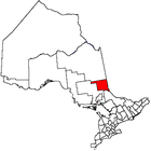 | |
|---|---|---|
| Towns | ||
| Townships | ||
| Village | ||
| Indian Reserves | ||
| Unorganized areas | ||
| Local services boards | ||
| ||