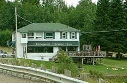
Kenogami Lake, Ontario
| Kenogami Lake | |
| Settlement | |
 Kenogami Lake | |
| Country | Canada |
|---|---|
| Province | Ontario |
| Region | Northeastern Ontario |
| District | Timiskaming |
| Part | Timiskaming, Unorganized, West |
| Elevation | 304 m (997 ft) |
| Coordinates | 48°06′15″N 80°12′02″W / 48.10417°N 80.20056°WCoordinates: 48°06′15″N 80°12′02″W / 48.10417°N 80.20056°W |
| Timezone | Eastern Time Zone (UTC-5) |
| - summer (DST) | Eastern Time Zone (UTC-4) |
| Postal code FSA | P0K |
| Area code | 705, 249 |
 Location of Kenogami Lake in Ontario | |
Kenogami Lake is an unincorporated place and community in the Unorganized West Part of Timiskaming District in northwestern Ontario, Canada.[1][2] It is located on Kenogami Lake on the Blanche River in the Saint Lawrence River drainage basin.
Transportation
The community is located on Ontario Highway 11 (at this point part of the Trans-Canada Highway), at the junction with Ontario Highway 568, that heads 2.4 kilometres (1.5 mi) east to Kenogami Lake Station, and just north of the junction with Ontario Highway 66.
The nearby Kenogami Lake Station is on Ontario Northland Railway main line, between Goldthorpe to the north and Swastika to the east.
References
- ↑ "Kenogami Lake". Geographical Names Data Base. Natural Resources Canada. Retrieved 2011-08-18.
- ↑ Map 15 (PDF) (Map). 1 : 1,600,000. Official road map of Ontario. Ministry of Transportation of Ontario. 2010-01-01. Retrieved 2011-08-18.
External links
| City | 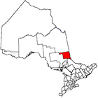 | |
|---|---|---|
| Towns | ||
| Townships | ||
| Village | ||
| Indian Reserves | ||
| Unorganized areas | ||
| Local services boards | ||
| ||
This article is issued from Wikipedia - version of the 11/20/2016. The text is available under the Creative Commons Attribution/Share Alike but additional terms may apply for the media files.