Colle Santa Lucia
| Colle Santa Lucia | |
|---|---|
| Comune | |
| Comune di Colle Santa Lucia | |
|
Colle Santa Lucia | |
 Colle Santa Lucia Location of Colle Santa Lucia in Italy | |
| Coordinates: 46°27′N 12°1′E / 46.450°N 12.017°ECoordinates: 46°27′N 12°1′E / 46.450°N 12.017°E | |
| Country | Italy |
| Region | Veneto |
| Province / Metropolitan city | Province of Belluno (BL) |
| Area | |
| • Total | 15.3 km2 (5.9 sq mi) |
| Population (Dec. 2004) | |
| • Total | 408 |
| • Density | 27/km2 (69/sq mi) |
| Time zone | CET (UTC+1) |
| • Summer (DST) | CEST (UTC+2) |
| Postal code | 32020 |
| Dialing code | 0437 |
| Website | www.collesantalucia.eu |
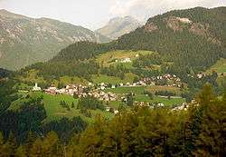
Colle Santa Lucia (Italian pronunciation: [ˈkɔlle ˈsanta luˈtʃiːa]; Ladin language: Col) is a comune (municipality) in the Province of Belluno in the Italian region of Veneto, located about 120 kilometres (75 mi) north of Venice and about 40 kilometres (25 mi) northwest of Belluno. As of 31st December 2004, it had a population of 408 and an area of 15.3 square kilometres (5.9 sq mi).[1] The population speaks a Venetian dialect called Ladin Venetian that is heavily influenced by the Ladin language.
Colle Santa Lucia borders the following municipalities: Alleghe, Cortina d'Ampezzo, Livinallongo del Col di Lana, Rocca Pietore, San Vito di Cadore, Selva di Cadore.
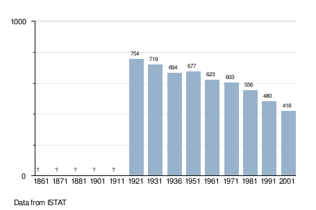
Demographic evolution
References
This article is issued from Wikipedia - version of the 12/3/2015. The text is available under the Creative Commons Attribution/Share Alike but additional terms may apply for the media files.