Tambre
For the Galician river, see Tambre (river).
| Tambre | |
|---|---|
| Comune | |
| Comune di Tambre | |
 Tambre Location of Tambre in Italy | |
| Coordinates: 46°8′N 12°25′E / 46.133°N 12.417°ECoordinates: 46°8′N 12°25′E / 46.133°N 12.417°E | |
| Country | Italy |
| Region | Veneto |
| Province / Metropolitan city | Province of Belluno (BL) |
| Frazioni | All'O',Broz, Civit, Pianon Sant'Anna, Fullin, Val Turcana, Tambruz, Lavina,Pian Cansiglio, Valdenogher |
| Area | |
| • Total | 45.6 km2 (17.6 sq mi) |
| Elevation | 922 m (3,025 ft) |
| Population (Dec. 2004) | |
| • Total | 1,501 |
| • Density | 33/km2 (85/sq mi) |
| Demonym(s) | Tambresi, Nel resto della provincia gli abitanti della conca dell' Alpago sono chiamti Alpagoti o "Pagot" |
| Time zone | CET (UTC+1) |
| • Summer (DST) | CEST (UTC+2) |
| Postal code | 32010 |
| Dialing code | 0437 |
| Website | Official website |
Tambre is a comune (municipality) in the Province of Belluno in the Italian region Veneto, located about 80 kilometres (50 miles) north of Venice and about 15 km (9 mi) east of Belluno. As of 31 December 2004, it had a population of 1,501 and an area of 45.6 square kilometres (17.6 sq mi).[1]
The municipality of Tambre contains the frazioni (subdivisions, mainly villages and hamlets) All'O',Broz, Civit, Pianon Sant'Anna, Fullin, Val Turcana, Tambruz, Lavina,Pian Cansiglio, and Valdenogher.
Tambre borders the following municipalities: Aviano, Barcis, Budoia, Caneva, Chies d'Alpago, Farra d'Alpago, Fregona, Polcenigo, Puos d'Alpago.
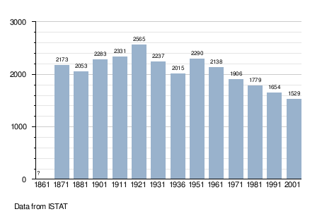
Demographic evolution
References
External links
This article is issued from Wikipedia - version of the 1/31/2015. The text is available under the Creative Commons Attribution/Share Alike but additional terms may apply for the media files.