Virginia State Route 244
| ||||
|---|---|---|---|---|
| Columbia Pike | ||||
 | ||||
| Route information | ||||
| Maintained by VDOT | ||||
| Length: | 8.25 mi[1] (13.28 km) | |||
| Existed: | 1933 – present | |||
| Major junctions | ||||
| West end: |
| |||
|
| ||||
| East end: |
| |||
| Location | ||||
| Counties: | Fairfax, Arlington | |||
| Highway system | ||||
| ||||

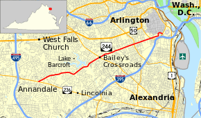
State Route 244 (SR 244) is a primary state highway in the U.S. state of Virginia. Known as Columbia Pike, the state highway runs 8.25 miles (13.28 km) from SR 236 in Annandale east to SR 27 and Interstate 395 (I-395) at The Pentagon in Arlington. SR 244 is a major southwest–northeast thoroughfare in northeastern Fairfax County and eastern Arlington County, connecting Annandale with SR 7 at Bailey's Crossroads and SR 120 in the multicultural Westmont neighborhood of Arlington.
Route description
SR 244 begins at an intersection with SR 236 (Little River Turnpike) in Annandale. The westernmost segment of the state highway is a one-way, two-lane street westbound that has access only to westbound SR 236. Two-way traffic on the highway begins at its intersection with SR 617 (Backlick Road), through which all other connections between SR 244 and SR 236 are made. SR 244 heads east out of the center of Annandale as a four-lane undivided highway that gains a median at its intersection with SR 711 (Gallows Road). The state highway veers northeast at its junction with SR 613 (Lincolnia Road) and SR 712 (Old Columbia Pike). SR 244 crosses Holmes Run as it curves around the southeastern end of Lake Barcroft. SR 244 has a partial cloverleaf interchange with SR 7 (Leesburg Pike) at Bailey's Crossroads before crossing the Fairfax–Arlington county line.[1][2]
SR 244 becomes an undivided highway shortly before Four Mile Run, where the highway also crosses the Four Mile Run Trail and intersects the Washington & Old Dominion Railroad Trail. The state highway intersects George Mason Drive, SR 120 (Glebe Road), and Walter Reed Drive in Westmont, which is a center for Arlington's immigrant community, with many stores, restaurants, and other businesses representing south Arlington's cultural diversity. East of Westmont, SR 244 has a partial cloverleaf interchange with SR 27 (Washington Boulevard) that provides access to both directions of I-395 (Henry G. Shirley Memorial Highway) at the western end of the Mixing Bowl interchange of the Pentagon road network. The state highway passes to the south of Henderson Hall, the headquarters of the United States Marine Corps. At the United States Air Force Memorial, SR 244 becomes a divided highway, passes through an S-curve, and briefly follows the southern edge of the Arlington National Cemetery reservation. Just to the east, the state highway has another partial cloverleaf interchange with SR 27 that provides access to southbound I-395. SR 244 reaches its eastern terminus at the eastern end of the interchange at the entrance to the Pentagon South parking lot.[1][2]
History
Columbia Pike dates to 1810 when the U.S. Congress chartered a turnpike Company to build three separate roads through the newly formed District of Columbia to outlying destinations.[3] One of these roads was to be built through a portion of the District of Columbia that had previously been part of Virginia. This portion was then known as Alexandria County, D.C. (now Arlington County, Virginia). The purpose of this road was to provide access westward from the new Long Bridge that predated the 14th Street Bridge complex to the Little River Turnpike Road, now Virginia State Route 236. The new road was built on a pre-existing cow path as the Washington Graveled Turnpike and was also known as the Washington Road, the Columbian Road, and the Arlington Turnpike. The U.S. Department of Agriculture paved the road with concrete in 1928 from the bridge west to Palmer's Hill in Barcroft as part of an experimental testing program.
.svg.png)
Columbia Pike was first numbered as State Route 720 in 1930 from U.S. Route 1 near the Long Bridge west for around 1 mile (1.6 km). In the 1933 renumbering, it was renumbered State Route 244 and the numbering was extended first to State Route 7 at Bailey's Crossroads and then, between 1934 and 1937, further west to its current terminus at SR 236 in Annandale. With the construction of the Pentagon Columbia Pike was replaced by the Shirley Highway as the Virginia approach to the Long Bridge/14th Street Bridge. By 1944, SR 244 was truncated at the Pentagon; the piece curving away from the original alignment became a state highway in 1964. Until the 1990s, Columbia Pike accommodated rush hour traffic by reversing the direction of one lane using overhead signals. In October 2010, Virginia transferred responsibility for the eastern portion of Columbia Pike to Arlington County.[4]
In 2002, Arlington County adopted the Columbia Pike Initiative, a revitalization plan for the three-and-a-half mile corridor in Arlington. The plan called for development of a high-capacity transit system. The Columbia Pike Initiative was followed in 2003 by adoption of the Form Based Code, which guides development along Columbia Pike. In 2004, the Columbia Pike Street Space Planning Task Force recommended future transit operate in mixed traffic and that the transitway be located in the curb lanes.[5]
Recent efforts by the Columbia Pike Revitalization Organization include the replacement of older traffic signals with newer and more aesthetic ones, and the addition of brick texture to crosswalks. County officials also teamed up with the Washington Metropolitan Area Transit Authority to increase mass transit service along the corridor. This new program called Pike Ride remodeled bus stops and doubled bus frequency along Columbia Pike. In 2006, the Arlington County and Fairfax County Board of Supervisors approved plans of bringing railed streetcars to Columbia Pike along an either a 5 or 6-mile (9.7 km) stretch from the Pentagon to the Skyline area.[5][6]
Major intersections
| County | Location | mi[1] | km | Destinations | Notes |
|---|---|---|---|---|---|
| Fairfax | Annandale | 0.00 | 0.00 | Western terminus; access from westbound SR 244 to westbound SR 236 only | |
| 0.10 | 0.16 | Backlick Road (SR 617 south) / Maple Place (SR 758) - Falls Church | east end of one-way westbound section | ||
| Belvedere | |||||
| Braddock Road (SR 620) | |||||
| Bailey's Crossroads | 4.06 | 6.53 | Partial cloverleaf interchange | ||
| Arlington | Westmont | 6.25 | 10.06 | ||
| | 7.28 | 11.72 | Partial cloverleaf interchange | ||
| | 8.25 | 13.28 | Eastern terminus; partial cloverleaf interchange | ||
| 1.000 mi = 1.609 km; 1.000 km = 0.621 mi | |||||
References
- 1 2 3 4 "2010 Traffic Data". Virginia Department of Transportation. 2010. Retrieved 2011-12-14.
- 1 2 Google (2011-12-14). "Virginia State Route 244" (Map). Google Maps. Google. Retrieved 2011-12-14.
- ↑ An Act to incorporate a company for making certain turnpike roads in the District of Columbia, 2 U.S. Statutes at Large 570 (Apr. 20, 1810). Unfortunately, the date is erroneously given as 1808 in some texts, which has led to confusion. See, e.g., C.B. Rose, Jr., Arlington County, Virginia: A History, p. 76 (1976).
- ↑ "Commonwealth Transportation Board Approves Pike Transfer to Arlington". Arlington County. September 16, 2010. Retrieved December 4, 2010.
- 1 2 News Release: Board Endorses Streetcars for Columbia Pike in official website of the government of Arlington County, VA, April 26, 2006. Accessed May 8, 2009.
- ↑ Fairfax Co. Backs Trolley Proposal Along Columbia Pike in wtop.com: official website of WTOP, May 1, 2006. Accessed May 8, 2009.
External links
- Virginia Highways Project: VA 244
- Columbia Pike Revitalization Organization
- Arlington's Urban Villages- Columbia Pike
- Washington Post article about proposed street cars along Columbia Pike
- Columbia Pike Transit Initiative
- Social History of Columbia Heights
| < SR 719 | District 7 State Routes 1928–1933 |
SR 721 > |