Fairfax, Virginia
| Fairfax, Virginia | ||
|---|---|---|
| Independent city | ||
| City of Fairfax | ||
| ||
| Nickname(s): Central Fairfax, Downtown Fairfax, Fairfax City, Historic Fairfax | ||
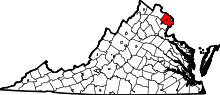
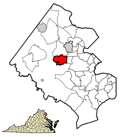 Location of Fairfax relative to Fairfax County, Virginia | ||
| Coordinates: 38°51′9″N 77°18′15″W / 38.85250°N 77.30417°W | ||
| Country | United States | |
| State | Virginia | |
| County | None (Independent city) | |
| Founded | 1805 | |
| Government | ||
| • Type | Mayor–council government | |
| • Mayor | Steven Stombres (Interim)[1] | |
| Area | ||
| • Total | 6.3 sq mi (16.3 km2) | |
| • Land | 6.3 sq mi (16.2 km2) | |
| • Water | 0.04 sq mi (0.1 km2) | |
| Elevation | 312 ft (95 m) | |
| Population (2010) | ||
| • Total | 22,565 | |
| • Estimate (2015) | 24,013 | |
| • Density | 3,849/sq mi (1,486.0/km2) | |
| Time zone | EST (UTC-5) | |
| • Summer (DST) | EDT (UTC-4) | |
| ZIP codes | 22030–22032 | |
| Area code(s) | 703, 571 | |
| FIPS code | 51-26496[2] | |
| GNIS feature ID | 1498476[3] | |
| Website |
www | |
Fairfax (/ˈfɛər.fæks/ FAIR-faks), colloquially Central Fairfax, Downtown Fairfax, Fairfax City, Historic Fairfax, or City of Fairfax, is an independent city in the Commonwealth of Virginia. As of the 2010 census the population was 22,565,[4] which had risen to an estimated 24,013 as of 2015.[5][6]
The city of Fairfax is an enclave within Fairfax County. However, Fairfax County is a separate political entity. The city of Fairfax, and the area immediately surrounding the historical border of the city of Fairfax, also officially designated by Fairfax County as "Fairfax", comprise the county seat of Fairfax County.
Situated in Northern Virginia, Fairfax is part of the Washington-Arlington-Alexandria, DC-VA-MD-WV Metropolitan Statistical Area. The city is 17 miles (27 km) west of Washington, D.C. The Washington Metro's Orange Line serves Fairfax through its Vienna station. CUE Bus and Metrobus operate in Fairfax.
George Mason University (GMU), Virginia's largest public institution, is located just outside the southern city limits in Fairfax County. In 2013, 33,917 students attended GMU. Virginia International University, an international school, is located in unincorporated Fairfax County just west of the Fairfax city limits.
History
The city derives its name from Thomas Fairfax, 6th Lord Fairfax of Cameron,[7] who was awarded five million acres (20,000 km²) of land in northern Virginia by King Charles. The area that the city now encompasses was settled in the early 18th century by farmers from Virginia's Tidewater region. The town of "Providence" was established on the site by an act of the state legislature in 1805.
The town (then described as a village) was the scene of the first land battle of the Civil War, the Battle of Fairfax Court House. On June 1, 1861, a Union scouting party clashed with the local militia, though neither side gained an advantage. A second battle was waged two years later on June 27, 1863. At the Battle of Fairfax Court House (June 1863), Union troops were defeated. However, the battle delayed the movements of Confederate cavalry chief Jeb Stuart, with disastrous consequences for Lee at Gettysburg a few days later.
Fairfax was officially renamed the "Town of Fairfax" in 1874. It was incorporated as a city in 1961, and under Virginia law was separated from Fairfax County (though it remains the county seat).[8]
In 1904, a trolley line was built connecting Fairfax with Washington, D.C.
Important buildings
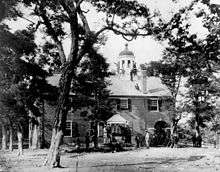
The former Fairfax County Courthouse is the oldest and most historic building in Fairfax. The first Fairfax courthouse was established in 1742 near present-day Tyson's Corner, and is the namesake for Old Courthouse Road.[9] It intersects with Gallows Road, which today is a major commuter route, but at the time was the road where condemned prisoners were led to the gallows at the old courthouse.[10] In 1752, the courthouse was moved to Alexandria, which offered to build the new courthouse at their own expense. (The reason the courthouse was moved from the Tyson's Corner location was because of "Indian hostilities", as noted on the stone marker at the northwest corner of Gallows Road and Route 123.) The courthouse operated there until 1790, when Virginia ceded the land where the courthouse was located for the creation of Washington, DC. The General Assembly specified that the new courthouse should be located in the center of the county, and was established at the corner of Old Little River Turnpike (now Main Street) and Ox Road (now Chain Bridge Road) on land donated by town founder Richard Ratcliffe.[11] The courthouse changed hands repeatedly during the Civil War, and the first officer casualty, John Quincy Marr, occurred on the grounds.[12]
Its design was used as a prototype for many Virginia courthouses built between 1800 and 1850. The first meeting of the Fairfax Court was held April 21, 1800. During the Civil War the courthouse was used by Union forces as a military headquarters, which resulted in the damage or loss of several records. The original Fairfax County Courthouse was used as the Fairfax County Juvenile and Domestic Relations Court until 2009, when that court moved to the expanded main courthouse. The old building is now used for office space.
One of the oldest buildings in the city is what used to be an elementary school. Built in 1873, the Fairfax Elementary School is the oldest two-story in the city and was built for the sum of $2,750. This building reflects a new era of free public education in Virginia and the growth of the Fairfax area. Throughout the years the school building was used for housing special education and adult education classes as well as a police academy training center. However, on July 4, 1992, the building was renovated and opened as the Fairfax Museum and Visitor Center.
The Old Town Hall is the social and architectural cornerstone of Fairfax; Joseph Edward Willard had it built in 1900 as a gift to Fairfax. It now houses the Huddleson Library and the Fairfax Art League, and can be rented out for weddings as well as business meetings.
Sites on the National Register of Historic Places
| Site | Year built | Address | Listed |
|---|---|---|---|
| 29 Diner (Tastee 29 Diner) | 1947 | 10536 Fairfax Boulevard | 1992 |
| Blenheim | 1855 | 3610 Old Lee Highway | 2001 |
| City of Fairfax Historic District | Junction of VA 236 and VA 123 | 1987 | |
| Old Fairfax County Courthouse* (now the Juvenile Court) | 1800 | 4000 Chain Bridge Road | 1974 |
| Old Fairfax County Jail* | 1891 | 10475 Main Street | 1981 |
| Fairfax Public School (Old Fairfax Elementary School Annex) | 1873 | 10209 Main Street | 1992 |
| Ratcliffe-Allison House | 1812 | 10386 Main Street | 1973 |
| *The Old Courthouse and the Old Jail lie within the county exclave within the city. | |||
Geography
The city of Fairfax is located close to the geographic center of Fairfax County, at 38°51′9″N 77°18′15″W / 38.85250°N 77.30417°W (38.852612, −77.304377). According to the United States Census Bureau, the city has a total area of 6.3 square miles (16.3 km2), of which all but 0.04 square miles (0.1 km2) is land.[4]
While the city is the county seat, a small portion of the county comprising the courthouse complex, the jail and a small area nearby is itself an exclave of the county within the city.[13][14][15] Fairfax County's Government Center is west of the City of Fairfax.[16]
Demographics
| Historical population | |||
|---|---|---|---|
| Census | Pop. | %± | |
| 1880 | 376 | — | |
| 1890 | 376 | 0.0% | |
| 1900 | 373 | −0.8% | |
| 1910 | 413 | 10.7% | |
| 1920 | 516 | 24.9% | |
| 1930 | 640 | 24.0% | |
| 1940 | 979 | 53.0% | |
| 1950 | 1,946 | 98.8% | |
| 1960 | 13,585 | 598.1% | |
| 1970 | 21,970 | 61.7% | |
| 1980 | 20,537 | −6.5% | |
| 1990 | 19,622 | −4.5% | |
| 2000 | 21,498 | 9.6% | |
| 2010 | 22,565 | 5.0% | |
| Est. 2015 | 24,013 | [5] | 6.4% |
| U.S. Decennial Census[17] 1790–1960[18] 1900–1990[19] 1990–2000[20] 2010–2015[21] | |||
As of the census[22] of 2010, there were 22,565 people, 8,347 households, and 5,545 families residing in the city. The population density was 3,581.7 people per square mile (1382.9/km²). There were 8,680 housing units at an average density of 1,377.8 per square mile (532.0/km²). The racial makeup of the city was 69.6% White, 4.7% Black or African American, 0.5% Native American, 15.2% Asian, 0.1% Pacific Islander, 5.9% from other races, and 4.0% from two or more races. 15.8% of the population were Hispanic or Latino of any race.
In 2000 there were 8,347 households out of which 28.2% had children under the age of 18 living with them, 53.1% were married couples living together, 9.6% had a female householder with no husband present, and 33.6% were non-families. 24.0% of all households were made up of individuals and 8.4% had someone living alone who was 65 years of age or older. The average household size was 2.64 and the average family size was 3.11.
In the city the population was spread out with 20.4% under the age of 18, 10.2% from 18 to 24, 36.2% from 25 to 44, 27.6% from 45 to 64, and 13.6% who were 65 years of age or older. The median age was 39.1 years. For every 100 females there were 97.2 males. For every 100 females age 18 and over, there were 95.6 males.
The median income for a household in the city was $67,642, and the median income for a family was $78,921 (these figures had risen to $93,441 and $105,046 respectively as of a 2007 estimate).[23] Males had a median income of $50,348 versus $38,351 for females. The per capita income for the city was $31,247. About 2.4% of families and 5.7% of the population were below the poverty line, including 4.3% of those under age 18 and 2.1% of those age 65 or over.
Economy
Old Town Fairfax has undergone an extensive redevelopment, which began in 2005.[24] The redevelopment added a new City of Fairfax Regional Library, more than 45,000 square feet (4,200 m2) of retail and restaurant space, more than 70,000 square feet (6,500 m2) of office condominiums, and 85 upscale residential condominium units.[25]
In May 2009, Fairfax was rated as No. 3 in the "Top 25 Places to Live Well" by Forbes Magazine.[26] Forbes commended Fairfax for its strong public school system, high median salary, and a rate of sole proprietors per capita that ranks it in the top 1 percent nationwide. According to the magazine, "These factors are increasingly important in a recession. When businesses and jobs retract, as they have nationwide, municipalities with strong environments for start-ups, and those that offer attractive amenities, are better suited to recover from economic downtimes, as there are more business activity filling the void."
Top employers
According to the city's 2015 Comprehensive Annual Financial Report,[27] the top employers in the city are:
| # | Employer | # of Employees |
|---|---|---|
| 1 | The Wackenhut Corporation | 410 |
| 2 | Fairfax Nursing Center | 400 |
| 3 | City of Fairfax | 397 |
| 4 | Inova Health System | 390 |
| 5 | Ted Britt Ford | 300 |
| 6 | Zeta Associates | 275 |
| 7 | Multivision, Inc. | 150 |
| 8 | Fairfax Volkswagen, Honda | 150 |
| 9 | Dominion Virginia Power | 150 |
Annual events
- Chocolate Lovers Festival
- The annual Chocolate Lover's Festival is held in the heart of Old Town Fairfax in early March. Events have included craft shows, historic building open houses, children's activities, collections of vendors selling various edible chocolate products, and even chocolate sculpture contests.[28]
- Fairfax Civil War Day
- Every year, during the Spring, a Civil War re-enactment camp is held at the Blenheim estate, a city-owned historical property. The encampment features military muster, drill, and a firing demonstration.[29]
- Fairfax Spotlight on the Arts
- Each April, the City of Fairfax, in cooperation with George Mason University, Northern Virginia Community College and City of Fairfax schools, sponsors the Fairfax Spotlight on the Arts Festival. The festival runs for three weeks and features music, dance, theater, art and choral concerts. Events take place at venues throughout the city and the colleges.[30]
- National Trails Day
- In June, a National Trails Day is held to celebrate the trails, open spaces and parks in the City of Fairfax.[31]
- Independence Day Celebration Parade and Evening Show
- The largest hometown parade and fireworks celebration in the Washington metropolitan region is held in the City of Fairfax. The day's events include a parade through Old Town Fairfax, tours of historic buildings and local museums, an Old Fashioned Fireman's Day at the Fire Station #3, and a live concert and fireworks display at Fairfax High School.[32]
- Irish Festival
- In September, a festival of Irish and Celtic song, dance and music is held in and around Old Town Fairfax.[33]
- Fall for the Book Festival
- Each fall, the Fall for the Book Festival features readings, discussions, lectures and exhibits from nationally-recognized writers and professionals. Festival events are held in the City of Fairfax, at George Mason University, and throughout the metropolitan Washington region. Two community reading programs coordinate with Fall for the Book: "All Fairfax Reads," coordinated by the Fairfax County Public Library, and "Mason Reads" at George Mason University.[34]
- Fall Festival
- A Fall Festival is held in historic downtown Fairfax on the second Saturday in October. This event includes more than 500 arts, crafts, and food vendors, and is usually held outdoors on the streets of the city. Attendance is about 35,000 to 45,000.[35]
- The Holiday Craft Show
- An annual Holiday Craft Show is held at Fairfax High School on the third Saturday and Sunday of November. The event features hundreds of craft vendors. Attendance is about 8,000 to 10,000.[36]
- Festival of Lights & Carols
- On the first Saturday in December, the city holds a Festival of Lights and Carols. Activities include photos with Santa, caroling, a yule log, hot mulled cider, illumination of Old Town Fairfax, and the lighting of the city Christmas tree.[37]
Notable people
- Roxanne Barcelo, Filipina actress, model, and singer
- L. A. "Skip" Bafalis, former member of the United States House of Representatives from Florida
- Adam Birch, former WWE professional wrestler known as Joey Mercury; born in Fairfax
- Bobby (Kim Ji-Won), rapper in popular South Korean pop group iKon
- Sam Champion (raised in Fairfax and a graduate of Fairfax High School), weather anchor of ABC's Good Morning America and weather editor of ABC News
- Serena Deeb, former WWE professional wrestler; born in Fairfax
- Will "Meteos" Hartman, League of Legends player for Cloud9, born in Massachusetts and raised in Fairfax
- Christina Hendricks, actress, went to high school in Fairfax
- Joseph R. Jelinek, United States Army brigadier general, lived in Fairfax while serving as Deputy Director of the Army National Guard
- Courtney Jines, actress
- Lamar Johnstone (1886–1919), silent film actor
- Brian Kendrick, WWE wrestler, born in Fairfax
- Sabrina Lloyd, actress on the TV series Sliders and Sports Night, born in Fairfax
- Jay Matternes, paleoartist
- TobyMac, award-winning Christian singer/songwriter
- Lorenzo Odone, subject of the 1992 film Lorenzo's Oil
- Park Yu-hwan, South Korean-born actor, and brother of Yoochun; raised in Fairfax.[38]
- Mike Schleibaum, band Darkest Hour founding member and guitarist, born in Fairfax
- Michael Schwimer, Major League Baseball player
- Nathan Sonenshein, rear admiral
- Victoria Stiles, makeup artist notable for her work with celebrities and fashion magazines
- Jason Sudeikis, actor and comedian, formerly a cast member of Saturday Night Live
- Pierre Thuot, Space Shuttle astronaut aboard Atlantis, Endeavour, and Columbia, raised in Fairfax and graduated from Fairfax High School
- Yoochun, South Korean-born actor, member of pop band JYJ, and former member of TVXQ; raised in Fairfax[38]
Local government and politics
Election results
| Year | Democratic | Republican |
|---|---|---|
| 2000 | 50.5% 4,777 | 49.4% 4,677 |
| 2002 | 81.2% 4,829 | |
| 2006 | 56.1% 4,541 | 42.6% 3,451 |
| 2008 | 67.1% 7,527 | 31.3% 3,515 |
| 2012 | 58.8% 6,728 | 40.9% 4,682 |
| 2014 | 54.5% 3,812 | 43.2% 3,018 |
| Year | Democratic | Republican |
|---|---|---|
| 1993 | 46.1% 2,920 | 53.5% 3,390 |
| 1997 | 46.4% 3,047 | 52.5% 3,451 |
| 2001 | 51.7% 3,478 | 47.6% 3,203 |
| 2005 | 57.2% 3,865 | 40.7% 2,750 |
| 2009 | 46.9% 2,909 | 53.0% 3,285 |
| 2013 | 55.4% 3,987 | 38.6% 2,777 |
| Year | Democratic | Republican |
|---|---|---|
| 1992 | 40.1% 3,884 | 44.7% 4,333 |
| 1996 | 44.7% 3,909 | 49.4% 4,319 |
| 2000 | 45.6% 4,361 | 49.8% 4,762 |
| 2004 | 51.2% 5,395 | 47.8% 5,045 |
| 2008 | 57.7% 6,575 | 41.2% 4,691 |
| 2012 | 57.2% 6,651 | 41.1% 4,775 |
Drugs-for-sex scandal
On August 4, 2016, then-Mayor Scott Silverthorne (D) was arrested in a sting operation conducted by the Fairfax County Police Department. After receiving a tip that he was involved in drugs-related activities online, a police detective engaged Silverthorne on an online website "...used to arrange for casual sexual encounters between men."[40] The detective then arranged a meeting with Silverthorne and two other men, in which they agreed to exchange methamphetamine for a group sexual encounter. At the meeting in Tyson's Corner, Virginia, detectives performed the exchange and then arrested Silverthorne along with the two other men. He was charged with felony distribution of methamphetamine and misdemeanor possession of drug paraphernalia.[40] He announced his resignation on Monday, August 8, 2016, in a letter to the City Council.[41]
Fairfax County facilities
Fairfax County's Government Center is west of the City of Fairfax.[16] Fairfax County contains an exclave located in the central area of the City of Fairfax, in which many county facilities (including the courthouse and jail) are located.[14][15]
Education
Primary and secondary schools
The public schools in the City of Fairfax are owned by the city, but administered by the Fairfax County Public Schools system under contractual agreement with Fairfax County.[42] U.S. News & World Report often ranks Fairfax County schools among the best in the country.
City of Fairfax schools are Fairfax High School, Lanier Middle School, Daniels Run Elementary School, Providence Elementary School, Mosby Woods Elementary School (which is a magnet school) and Fairfax Academy.[42]
Colleges and universities
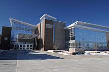
George Mason University, the largest university in the Commonwealth of Virginia, is located just to the south of the Fairfax city limits.[43] The Town of Fairfax purchased 150 acres (0.61 km2) for the university in 1958, though the property remained within the county when the town became a city. In 1966, GMU became a four-year university just outside the city. Along with various administrative offices, the Fairfax campus also contains such facilities as the Center for the Arts complex,[44] EagleBank Arena, a 66,000-square-foot (6,100 m2) Aquatic and Fitness Center, and a 113,900-square-foot (10,580 m2) Recreation Sports Complex.[45]
Northern Virginia Community College, the second largest multi-campus community college in the United States, and the largest educational institution in Virginia, has its Annandale Campus immediately to the east of the city limits.
Public libraries
Fairfax County Public Library operates the City of Fairfax Regional Library in Fairfax. The library includes the Virginia Room, a collection of books, photographs, and manuscripts related to Fairfax County history, government, and genealogy.[46]
Sports
Rugby League
The Fairfax Eagles rugby league team plays in the American National Rugby League.
Infrastructure
Transportation
Roads
The intersection of U.S. Route 50 and U.S. Route 29 is located in the northeast corner of the city. The two major highways join to form Fairfax Boulevard for approximately 2.8 miles (4.5 km) through the city before separating. State Route 123 and State Route 236 both pass through the city. SR 236 is named Main Street in the city and then becomes Little River Turnpike once the city line is crossed. In addition, Interstate 66 is located along the northern border of the city.
Public transportation
Rail
Although these stations are located outside city limits, trips to and from Fairfax are served by:
- The Vienna station of the Washington Metro
- The Burke Centre station of Virginia Railway Express and Amtrak
Bus
- The City of Fairfax operates the CUE Bus, an independent bus network.
- Multiple routes of the Washington Metrobus serve Fairfax.
See also
- Fairfax County, Virginia
- List of Famous People from the Washington Metropolitan Area
- National Register of Historic Places in Fairfax, Virginia
Notes
- ↑ "City Council Selects 2/7/2017 for Special Election, Names Stombres as Interim Appointment for Mayor". City of Fairfax. 2016-08-17. Retrieved 2016-08-17.
- ↑ "American FactFinder". United States Census Bureau. Archived from the original on September 11, 2013. Retrieved 2008-01-31.
- ↑ "US Board on Geographic Names". United States Geological Survey. 2007-10-25. Retrieved 2008-01-31.
- 1 2 "Geographic Identifiers: 2010 Demographic Profile Data (G001): Fairfax city, Virginia". U.S. Census Bureau, American Factfinder. Retrieved October 20, 2016.
- 1 2 "Annual Estimates of the Resident Population for Incorporated Places: April 1, 2010 to July 1, 2015". Retrieved July 2, 2016.
- ↑ "Find a County". National Association of Counties. Archived from the original on May 31, 2011. Retrieved 2011-06-07.
- ↑ Gannett, Henry (1905). The Origin of Certain Place Names in the United States. Govt. Print. Off. p. 123.
- ↑ History of the City of Fairfax, Virginia Archived May 5, 2006, at the Wayback Machine.. Fairfaxva.gov.
- ↑
- ↑ A Look Back at Braddock District History Archived October 5, 2011, at the Wayback Machine.
- ↑ HFCI31.pmd. (PDF) .
- ↑ History of the Courthouse – Fairfax County, Virginia. Fairfaxcounty.gov (November 26, 2008).
- ↑ "Map LU-1 Existing Land Use." City of Fairfax. Retrieved on April 4, 2009.
- 1 2 "Fairfax city, Virginia Archived December 18, 2005, at the Wayback Machine.." U.S. Census Bureau. Retrieved on April 4, 2009.
- 1 2 "Fairfax County General District Court Archived March 31, 2009, at the Wayback Machine.." Fairfax County. Retrieved on April 4, 2009.
- 1 2 "Facilities & Locations." Fairfax County. Retrieved on April 4, 2009.
- ↑ "U.S. Decennial Census". United States Census Bureau. Archived from the original on May 11, 2015. Retrieved January 2, 2014.
- ↑ "Historical Census Browser". University of Virginia Library. Retrieved January 2, 2014.
- ↑ "Population of Counties by Decennial Census: 1900 to 1990". United States Census Bureau. Retrieved January 2, 2014.
- ↑ "Census 2000 PHC-T-4. Ranking Tables for Counties: 1990 and 2000" (PDF). United States Census Bureau. Retrieved January 2, 2014.
- ↑ "Annual Estimates of the Resident Population for Incorporated Places: April 1, 2010 to July 1, 2015". Retrieved June 4, 2015.
- ↑ "American FactFinder". United States Census Bureau. Archived from the original on September 11, 2013. Retrieved 2011-05-14.
- ↑ Fairfax city, Virginia – FactSheet – American FactFinder. Factfinder.census.gov.
- ↑ Old Town Fairfax Redevelopment Project Timeline. Fairfaxva.gov.
- ↑ Old Town Village Redevelopment. Fairfaxva.gov.
- ↑ "In Depth: America's Top 25 Towns To Live Well 3. Fairfax, Va". Forbes (May 22, 2002).
- ↑ "City of Fairfax, VA : Comprehensive Annual Financial Report (CAFR)". www.fairfaxva.gov. Retrieved 2016-08-22.
- ↑ About The Chocolate Lover's Festival. Chocolatefestival.net.
- ↑ City of Fairfax – Special Events, Civil War Weekend. Fairfaxva.gov (May 5, 2012).
- ↑ Fairfax Spotlight on the Arts. Fairfaxspotlight.org.
- ↑ fairfaxtrails.com
- ↑ City of Fairfax – Special Events, Independence Day Celebration. Fairfaxva.gov.
- ↑ City of Fairfax – Special Events. Fairfaxva.gov.
- ↑ http://www.fallforthebook.org
- ↑ City of Fairfax – Special Events, Fall Festival. Fairfaxva.gov.
- ↑ City of Fairfax – Special Events, Holiday Craft Show. Fairfaxva.gov.
- ↑ City of Fairfax – Special Events. Fairfaxva.gov.
- 1 2 Kang, Cecilia (2006-11-26). "Riding the Seoul Train". The Washington Post. Retrieved 2009-02-27.
- 1 2 3 Leip, David. "General Election Results – Virginia". United States Election Atlas. Retrieved January 10, 2013.
- 1 2 "Three Arrested for Distribution of Methamphetamine". Fairfax County Police Department Public Affairs Bureau. Fairfax County Police Department. Retrieved 19 October 2016.
- ↑ Olivo, Antonio (August 8, 2016). "Fairfax Mayor Scott Silverthorne to resign after sex-for-drugs arrest". The Washington Post. Retrieved 19 October 2016.
- 1 2 "City of Fairfax Schools". City of Fairfax. Retrieved 4 November 2015.
- ↑
- ↑ Center for the Arts – George Mason University. Gmu.edu.
- ↑ About the Fairfax Campus – Fairfax Campus – George Mason University Archived May 3, 2009, at the Wayback Machine.
- ↑ Library Branches Fairfax County Public Library. Retrieved on October 21, 2009.
References
- City of Fairfax Courting History: A Walking Tour of Old Town Fairfax, VA brochure
- Netherton, Rose; Meyer, Wagner, DiVincenzo. Fairfax, Virginia: A City Traveling Through Time (1999)
- Jeanne Johnson Rust. The History of the Town of Fairfax(1960)
External links
| Wikivoyage has a travel guide for Fairfax (Virginia). |
- City of Fairfax official website
- Historic Fairfax City, Inc. – The Historical Society of Fairfax City, Virginia
- Fairfax Crime – a crime map of most of Northern Virginia
Coordinates: 38°51′09″N 77°18′16″W / 38.852612°N 77.304377°W
 |
Chantilly | Oakton | Merrifield | |
| Fair Lakes | |
Mantua | ||
| ||||
| | ||||
| Colchester Hunt | Kings Park West | Ravensworth |
| Principal cities |
| |||||||||||
|---|---|---|---|---|---|---|---|---|---|---|---|---|
| Counties and county equivalents* |
| |||||||||||
The District of Columbia itself, and Virginia's incorporated cities, are county equivalents. Virginia's incorporated cities are listed under their surrounding county. The incorporated cities bordering more than one county (Alexandria, Falls Church and Fredericksburg) are listed under the county they were part of before incorporation as a city. | ||||||||||||

