Comanche, Montana
| Comanche, Montana | |
|---|---|
| Unincorporated community | |
 Comanche, Montana  Comanche, Montana | |
| Coordinates: 45°59′51″N 108°46′24″W / 45.99750°N 108.77333°WCoordinates: 45°59′51″N 108°46′24″W / 45.99750°N 108.77333°W | |
| Country | United States |
| State | Montana |
| County | Yellowstone |
| Elevation | 3,747 ft (1,142 m) |
| Population (2010)[1] | |
| • Total | 26 |
| Time zone | Mountain (MST) (UTC-7) |
| • Summer (DST) | MDT (UTC-6) |
| ZIP code | 59002 |
| Area code(s) | 406 |
| GNIS feature ID | 777090[2] |
Comanche is an unincorporated community in Yellowstone County, Montana. It lies on Montana Highway 3, 16 miles northwest of the city of Billings and shares a postal ZIP code with Acton (59002). Its elevation is 3,747 ft. (1142 m.), its coordinates are 45|59|51|N|108|46|24|W
History
Comanche was established as a railroad station on the Great Northern Railroad northwest of Billings. It was named for the famous horse that was the only living thing found on the battlefield after the Battle of the Little Big Horn as was the town's geographical region, Comanche Flat.
The village declined with the advent of changing transportation technologies and demographics. A Methodist Church and parsonage once existed in Comanche before being moved to nearby Broadview.
Comanche today has little left of its original structures. Some newer subdivisions, the original grain elevator, the depot, a hotel, the main street, and Comanche Cemetery west of town are all that remain. The post office was active in Comanche from 1909 to 1942 with Lola Dell Helm as postmaster.
References
- ↑ "American FactFinder". United States Census Bureau. Archived from the original on 2013-09-11. Retrieved 2011-05-14.
- ↑ "Comanche". Geographic Names Information System. United States Geological Survey.
Municipalities and communities of Yellowstone County, Montana, United States | ||
|---|---|---|
| Cities | 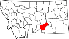 | |
| Town | ||
| CDPs | ||
| Other unincorporated communities | ||
| Indian reservation | ||
| Ghost town | ||
| Footnotes | ‡This populated place also has portions in an adjacent county or counties | |