Comb Ridge
| Comb Ridge Tséyíkʼáán (Navajo) | |
|---|---|
|
Comb Ridge from the air, above Bluff Utah and the San Juan River | |
| Location | southeast Utah, northeast Arizona |
| Nearest city | Blanding, Utah |
| Coordinates | 37°25′39″N 109°38′47″W / 37.42750°N 109.64639°WCoordinates: 37°25′39″N 109°38′47″W / 37.42750°N 109.64639°W |
| Designated | 1976 |
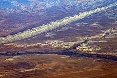
Comb Ridge (Navajo: Tséyíkʼáán[1]) is a linear north to south-trending monocline nearly 80 miles long in southeast Utah and northeast Arizona. Its northern end merges with the Abajo Mountains some eleven miles west of Blanding. It extends essentially due south for 45 km (28 mi) to the San Juan River. South of the San Juan the ridge turns to the southwest and is more subdued in expression as it extends for an additional 67 km (42 mi) to Laguna Creek 9 km (5.6 mi) east of Kayenta, Arizona.[2][3] It was designated a National Natural Landmark in 1976 as the only North American location of tritylodont fossils.[4]
Geology
The geologic formations involved in the east dipping strata of the fold include the Jurassic aged Navajo Sandstone, Kayenta Formation, Wingate Sandstone, Chinle Formation, Triassic Moenkopi Formation and Permian Organ Rock Formation. The structure is the surface expression of a deep fault along the east margin of the Monument Uplift.[2]
History
Traces of the Ancient Pueblo Peoples culture can be found along the southern part of the ridge where it follows Chinle Wash. The Macomb and Hayden expeditions in 1869 and 1874–1876, respectively, were the first to publish maps and descriptions of this feature.[5] The ridge and adjacent Butler Wash were given their current names in 1884, by P. Holmann.[5][6][7]
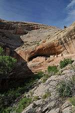
Numerous cliff dwellings are found along the ridge.
-
Monarch Cave Ruin cliff dwelling on Comb Ridge
-

Monarch Cave Ruin cliff dwelling on Comb Ridge
-

House on Fire Ruin near Comb Ridge
See also
References
- ↑ Linford, Laurence D. Navajo Places: History, Legend, Landscape, University of Utah Press, Salt Lake City, UT 2000
- 1 2 Geosights, Comb Ridge, San Juan County, Utah, May 2012, p. 9-11
- ↑ USGS 30x60 quadrangle topographic maps: Blanding, Utah-Colorado; Bluff, Utah-Colorado; Rock Point, Arizona-New Mexico; Kayenta, Arizona
- ↑ "National Natural Landmark". National Park Service. Retrieved 11 December 2012.
- 1 2 Gregory, H.E., 1938, The San Juan Country, a Geographic and Geologic Reconnaissance of Southeastern Utah: U.S. Geological Survey Professional Paper 188, p. 123
- ↑ Roberts, David (March 2006). "Hiking Comb Ridge". National Geographic Adventure Magazine. Retrieved 2009-05-06.
- ↑ Roberts, David. Sandstone Spine: Seeking the Anasazi on the First Traverse of the Comb Ridge. Mountaineers Books. ISBN 1-59485-005-4.