Trail of the Ancients
The Trail of the Ancients is a National Scenic Byway located in the states of Colorado and Utah. The route highlights the archaeological and cultural history of southwestern Native American peoples, and traverses the widely diverse geological landscape of the Four Corners region. It was the first National Scenic Byway that was designated solely for its archaeological sites. The entire route is approximately 480 miles (772.5 km) long.
Route description
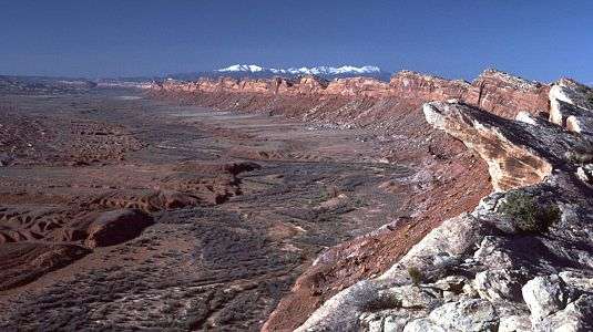
The National Scenic Byway crosses the Colorado Plateau of the Four Corners region along prehistoric sites of Native Americans, including the Navajo, Utes and early puebloan people, who lived and farmed in the area from about 1 CE to about 1300 CE. There were people hunting and gathering for food in the Four Corners region by 10,000 B.C. or earlier. Geological features include sandstone-rimmed canyons, snow-capped mountains, red rock landscapes and green valleys. Most of the stops — archaeological sites, Native American lands or modern communities — are near or on paved roads, but some of the roads are rugged graded roads.[1]
Colorado
Four Corners to Mesa Verde

Four Corners Monument recognizes the only quadripoint in the United States.[1] Members of the Navajo Nation (Utah, Arizona, and New Mexico), and the Ute Mountain Indian Reservation (Colorado) live in the Four Corners region on land surrounding the monument.[2]
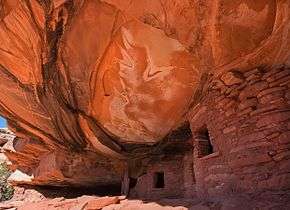
From the monument follow U.S. Route 160[nb 1] in a northeasterly direction to the junction of U.S. Route 491. Travel north on U.S. Route 160 / U.S. Route 491.[3] The second site on the byway is the Ute Mountain Tribal Park, its southwestern corner is at this junction. The park has archaeological evidence of Ancestral Puebloan sites and the Ute culture. Ute Indians lead guided tours to sites, like the Tree House Kiva.[1][4][nb 2]

The route continues along U.S. Route 160 / 491 to Cortez,[3] the county seat of Montezuma County. Two sites there are the Cortez Cultural Center, and its Hawkins Preserve and Hawkins Pueblo.[5] The Cortez Cultural Center has interpretive exhibits of the Navajo and Ute Native Americans and the early Puebloan people.[1]
At Cortez, Main Street / U.S. 160 runs east to the entrance of Mesa Verde National Park,[3] a U.S. national park preserving over 4000 archaeological sites, including 600 cliff dwellings, of the Ancestral Pueblo people.[6] It is a designated World Heritage Site.[1]
Return on US-160 to Cortez and the intersection of SR-145.[3]
Cortez to Hovenweep
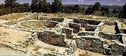
Travel northeast on SR-145/County Road 27/State Street to Dolores. Turn left onto County Road 28/Colorado State Highway 184[3] and travel to the Anasazi Heritage Center, a museum of the Ancient Pueblo (or Anasazi) culture and other Native cultures in the Four Corners region with over 3 million artifacts. Escalante and Dominguez Pueblos are located on the center's site. The Canyons of the Ancients National Monument visitor center has information for Lowry Pueblo and other Canyons of the Ancients sites.[1][7]
Continue on Colorado State Highway 184 to U.S. 491/N. Broadway in Lewis.[3]

Travel northwest on U.S. 491, passing through Yellow Jacket to Montezuma County Road CC, just south of Pleasant View[3] which is the beginning of the Canyons of the Ancients National Monument.[7][8]
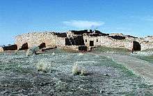
Travel west on Montezuma County Road CC to Lowry Pueblo.[3][nb 3] Lowry Pueblo is a National Historic Landmark originally excavated in the 1930s and dating to around 1060 AD.[1][10] The pueblo is part of Canyon of the Ancients National Monument, a Bureau of Land Management site encompassing over 6000 archaeological ruins over 183,000 acres.[8]

Return east on Montezuma County Road CC to Montezuma County Road 10. Travel south and west on Montezuma County Road 10,[3] through the Canyon of the Ancients,[8] before reaching the Utah state line, where it becomes San Juan County Road 212 (Hovenweep Road).[3] The route passes some of the outlying sites of Hovenweep National Monument[11]
The road turns south and intersects with the main entrance to Hovenweep past the Colorado-Utah border.[3] The Hovenweep National Monument preserves six sites in Utah and Colorado of Ancestral Puebloan settlements. The Square Tower is easily accessible, but other buildings require hiking or driving on rugged backroads.[1][11]
Utah
Hovenweep to Bluff and Blanding
After crossing the state border into Utah, travel Hovenweep Road/County 212 to the entrance to the Hovenweep National Monument Visitor Center. From there, head west on Hovenweep Road, which is multiple roads along the 30 miles: CR 212, CR 413, Reservation Road, Hovenweep Road/Indian Route 5099 and UT 262. Continue on 262 south of White Mesa to the junction with U.S. Route 191.[3]
From there, the route travels north on U.S. Route 191 through White Mesa, past the intersection with SR-95, to Blanding. In Blanding is Edge of the Cedars State Park (660 West 400 North) has Anasazi ruins, a museum, and some very well preserved artifacts that provide a detailed view of how the Ancestral Puebloan lived and worked.[12][13]
The byway extends north of Blanding to Monticello, Utah[nb 4] to the intersection of U.S. Route 491. Then, returns along U.S. Route 191 to Blanding.[3][15]
Blanding to Natural Bridges
On the return south through Blanding on U.S. Route 191 and turn on Utah State Route 95.[3] Head west to the turn offs for Comb Ridge and Comb Wash. The route ascends the eastern side of Cedar Mesa. Nearby ruins include the partially reconstructed Mule Canyon Ruin and the Butler Wash cliff dwellings.[13][15][16]
-
Comb Wash
-
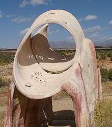
Natural Bridge Owachomo
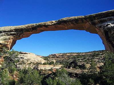
Back on Utah State Road 95, past the intersection with Utah State Route 261 to Utah State Route 275 / Natural Bridge Road. Take the road to the entrance to Natural Bridges National Monument.[3] The park loop goes past three of the largest natural bridges in the world.[17]
Grand Gulch to Monument Valley
From the Natural Bridges National Monument, return on UT 275 to UT-95. Head south on UT-95 to Utah State Route 261. Head south to U.S. Route 163.[3]
The route descends Cedar Mesa at Moki Dugway, and enters the scenic Valley of the Gods. A few miles through the valley is the turnoff for Goosenecks State Park; shortly after,[13][15] UT-261 ends at U.S. Route 163.[3]
-
Monument Valley
-

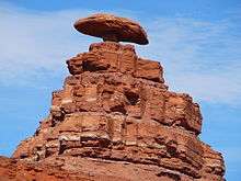
Muley Point, near Mexican Hat
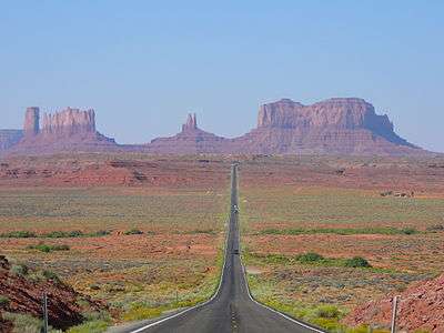
On U.S. Route 163 the byway heads south for 25 miles to the Utah / Arizona state border towards Monument Valley. Passing through the town of Mexican Hat.[3] This stretch of the byway ends at Monument Valley,[3] where there are massive rock formations and the Monument Valley Navajo Tribal Park.[13]
Mexican Hat to Four Corners
From Mexican Hat, travel north and east on U.S. Route 163 to the intersection of Utah State Road 162 and U.S. Route 191.[3]
Travel east from Bluff on Utah State Route 162. The byway borders the San Juan River and passes through Montezuma Creek, UT and Aneth, UT. Utah State Route 162 becomes CO-41 at the Colorado border. Travel on CO-41 to U.S. 160 for five miles southwest to the Four Corners to complete the byway loop.[3]
Neighboring byways
San Juan Skyway
A section of the Trail of the Ancients from Mesa Verde is part of the San Juan Skyway, a National Scenic Byway also designated as an All-American Road.[4][18][19]
Kayenta-Monument Valley Scenic Road
The southwestern end of the byway marks the northern end of the Kayenta-Monument Valley Scenic Road, which follows U.S. 163 from Monument Valley south to Kayenta.
Monument Valley to Bluff Scenic Byway
U.S. 163 from Monument Valley to Bluff is also its own designated scenic byway, the Monument Valley to Bluff Scenic Byway.
Bicentennial Scenic Byway
The stretch of road from Blanding to Natural Bridges National Monument along Utah State Route 95 is also the Bicentennial Scenic Byway, which continues north on UT-95 to Hanksville, UT.
History
In 1994 the Colorado Trail of the Ancients was designated a Colorado Scenic Byway.[20] The Utah Trail of the Ancients was made a state byway about 1990. Since each state's designation, improvements have been made towards national eligibility.[21]
The Trail of the Ancients was designated a National Scenic Byway on September 22, 2005 by the U.S. Secretary of Transportation and the Federal Highway Administration.[22][23] The designation was the first National Scenic Byway that totally focused its sites' archaeological qualities.[21][24][nb 5]
Arizona and New Mexico are applying to have the portions of the Trail of the Ancients in their states designated National Scenic Byways. This would include the Navajo National Monument and the Canyon de Chelly National Monument. When all four states have official national designations the Trail of the Ancients will acquire the highest status for roads, All-American Road.[21]
The New Mexico Trail of the Ancients was made a New Mexico Scenic Byway after July 13, 1998 and by 2013.[27][28] As of mid-August 2014, neither Arizona or New Mexico has received a National Scenic Byway designation for the Trail of Ancients portions of the byway in their states.[29]
See also
 U.S. Roads portal
 Colorado portal
 Utah portal
- Scenic byways in the United States
Notes
- ↑ At the intersection of State Road-41, the northwesterly road leads to the Utah Trail of the Ancients
- ↑ Along the route is the Yucca House National Monument, an unexcavated Ancestral Puebloan site.[5]
- ↑ This section of the byway crosses parts of the Old Spanish National Historic Trail, a historic trade route connecting Santa Fe with Los Angeles.[9]
- ↑ North of Monticello is the Newspaper Rock State Historic Monument, which has petroglyphs of people who lived in the area 2,000 years ago.[14]
- ↑ Senate Bill 1414 was introduced on July 15, 2005 calling for a "study of the suitability and feasibility of establishing the Trail of the Ancients National Heritage Area in the Four Corners region of the States of Utah, Colorado, Arizona, and New Mexico." The Heritage Area was to include the Trail of Ancients Scenic Byway. It was not enacted.[25][26]
References
- 1 2 3 4 5 6 7 8 Trail of the Ancients brochure. Trail of the Ancients Byway Association. Retrieved August 13, 2014.
- ↑ Four Corners Monument. Utah Travel Industry. Retrieved August 13, 2014.
- 1 2 3 4 5 6 7 8 9 10 11 12 13 14 15 16 17 18 19 20 21 Driving the Byway. America's Byways - Trail of the Ancients. Department of Transportation. Retrieved August 13, 2014.
- 1 2 Trail of the Ancients map. Trail of the Ancients. Retrieved August 13, 2014.
- 1 2 "Cortez Cultural Center." Retrieved on 2010-07-09.
- ↑ "Mesa Verde National Park." National Park Service. Retrieved 2010-07-09.
- 1 2 "Anasazi Heritage Center."" Bureau of Land Management. Retrieved 2010-07-11.
- 1 2 3 "Canyons of the Ancients: Background." Bureau of Land Management. Retrieved 2010-07-09.
- ↑ "Old Spanish Trail Association." Retrieved 2010-07-09.
- ↑ "Lowry Pueblo." Bureau of Land Management. Retrieved 2010-07-09.
- 1 2 Hovenweep Visitor Guide, National Park Service. Retrieved August 13, 2014.
- ↑ "Edge of the Cedars State Park." Retrieved 2010-07-11.
- 1 2 3 4 Trail of the Ancients brochure. Trail of the Ancients Byway Association. p. 2 Retrieved August 13, 2014.
- ↑ Newspaper Rock State Historic Monument. Desert USA. Retrieved August 13, 2014.
- 1 2 3 Utah Trail of the Ancients map. Trail of the Ancients Byway Association. Retrieved August 13, 2014.
- ↑ "Trail of the Ancients Scenic Byway." Retrieved 2010-07-11.
- ↑ "Natural Bridges National Monument." Retrieved 2010-07-11.
- ↑ Neighboring Byways. Trail of the Ancients. Retrieved August 13, 2014.
- ↑ San Juan Skyway. Neighboring Byways. Trail of the Ancients. Retrieved August 13, 2014.
- ↑ Trail of the Ancients Corridor Management Plan. Colorado Department of Transportation. 2009. Retrieved August 13, 2014.
- 1 2 3 Thomas Wharton. "Focus on archaeology a national system first" Salt Lake Times. December 25, 2005. Retrieved August 13, 2014.
- ↑ Trail of the Ancients. Scenic Byways. Colorado Department of Transportation. August 13, 2014.
- ↑ Trail of the Ancients Scenic Byway. Utah Travel Industry. October 4, 2005. Retrieved August 13, 2014.
- ↑ National Scenic Byways Program. U.S. Department of Transportation. Retrieved August 12, 2014.
- ↑ Senate bill 1414 - Trail of the Ancients National Heritage Act Study Act of 2005 - introduced July 15, 2005. GovTrak. Retrieved August 13, 2014.
- ↑ Congress. Congressional Record, V. 151, Pt. 12, July 14 to July 22, 2005. Government Printing Office. p. 337. GGKEY:EQ7ZDQLQWX8.
- ↑ 18 NMAC 31.2 New Mexico Scenic and Historic Byways Program. Transportation and Highways. New Mexico Legislation. Filed February 27, 1998. Effective July 31, 1998. Retrieved August 10, 2014.
- ↑ New Mexico Designated Unique or Valuable Scenic Landscapes. United States Department of Agriculture. Natural Resources Conservation Service. Issued in 2013. Retrieved August 11, 2014. Note: Not the best source as not an official list, but it wouldn't have made it onto the list if it wasn't a byway at that point
- ↑ America Byways. Federal Highway Administration. Retrieved August 13, 2014.
External links
| Overview | |||||||||||||||
|---|---|---|---|---|---|---|---|---|---|---|---|---|---|---|---|
| Contemporary peoples native to Colorado |
| ||||||||||||||
| Prehistoric cultures in Colorado |
| ||||||||||||||
| Related articles | |||||||||||||||