Connecticut Route 171
| ||||
|---|---|---|---|---|
|
Map of northeastern Connecticut with Route 171 highlighted in red | ||||
| Route information | ||||
| Maintained by ConnDOT | ||||
| Length: | 20.70 mi[1] (33.31 km) | |||
| Existed: | 1959 – present | |||
| Major junctions | ||||
| West end: |
| |||
| East end: |
| |||
| Location | ||||
| Counties: | Tolland, Windham | |||
| Highway system | ||||
| ||||

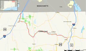
Route 171 is a state highway in northeastern Connecticut, running from Union to Putnam.
Route description
Route 171 begins at an interchange from I-84 in northern Union (Also known as Mashapaug) and heads south to the town center, then east, south, and southeast into Eastford. It cuts across the northeast corner of Eastford into Woodstock. In Woodstock, it heads southeast, then turns northeast, briefly overlapping Route 198 before continuing. It then passes Toutant Airport and turns east, briefly overlapping Route 169 before cutting across the southwest corner of Thompson into Putnam. In Putnam, it continues southeast before ending at an intersection with US 44 and Route 12.[1]
History
The portion of modern Route 171 between South Woodstock and Woodstock Valley was part of an early toll road known as Woodstock and Somers Turnpike. This section of the turnpike became part of a state highway in 1922 with the designation Highway 183. Old Highway 183 continued south of Woodstock Valley to Eastford along modern Route 198. Between Putnam and South Woodstock, modern Route 171 was part of Highway 142, which continued north along modern Route 169 to North Woodstock and the Massachusetts state line. In Union, the Buckley Highway became Highway 149.
In the 1932 state highway renumbering, Route 91 was created from old Highway 183. It began further south than the old route at US 6 in Chaplin using modern Route 198 and extended further east to Route 12 in Putnam (along part of old Highway 142). At the same time, the Buckley Highway became part of Route 15 and Bigelow Hollow Road became Route 198.
In 1959, Route 91 was renumbered as a result of the designation of Interstate 91 to avoid a numbering conflict. Route 171 was created from part of former Route 91, running from Woodstock Valley to the current eastern terminus at Route 12. The portion between Woodstock Valley and Chaplin became part of an extended Route 198. In 1963, Routes 171 and 198 were reconfigured to their current locations, resulting in part of Route 198 being redesignated as a westward extension of Route 171.[2]
Junction list
| County | Location | mi[1] | km | Destinations | Notes |
|---|---|---|---|---|---|
| Tolland | Union | 0.00 | 0.00 | Exit 74 (I-84) | |
| 2.76 | 4.44 | ||||
| 5.04 | 8.11 | ||||
| Windham | Woodstock | 9.53 | 15.34 | Southern terminus of CT 198 overlap | |
| 10.43 | 16.79 | Northern terminus of CT 198 overlap | |||
| 17.17 | 27.63 | Northern terminus of CT 169 overlap | |||
| 17.53 | 28.21 | Southern terminus of CT 169 overlap | |||
| Putnam | 20.70 | 33.31 | Eastern terminus of CT 171 | ||
1.000 mi = 1.609 km; 1.000 km = 0.621 mi
| |||||
References
- 1 2 3 Connecticut State Highway Log Archived 2015-07-26 at WebCite
- ↑ Connecticut Routes, Route 171
External links
| Wikimedia Commons has media related to Connecticut Route 171. |