Connecticut Route 197
| ||||
|---|---|---|---|---|
|
Map of northeastern Connecticut with Route 197 highlighted in red | ||||
| Route information | ||||
| Maintained by ConnDOT | ||||
| Length: | 10.97 mi[1] (17.65 km) | |||
| Existed: | 1932 – present | |||
| Major junctions | ||||
| West end: |
| |||
| East end: |
| |||
| Location | ||||
| Counties: | Tolland, Windham | |||
| Highway system | ||||
| ||||

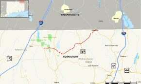
Route 197 is a state highway in northeastern Connecticut, running from Union to the Massachusetts state line in Thompson.
Route description
Route 197 begins as Lawson Road at an intersection with Route 171 in southeastern Union. It heads east towards Woodstock, entering the town after 0.9 miles (1.4 km) and becoming Red White School Road. Route 197 travels east for about 6.3 miles (10.1 km) through rural northern Woodstock, becoming Old Turnpike Road after two miles (3 km) and curving southeast and then northeast across the town, and intersecting Route 198. Route 197 eventually reaches the village of North Woodstock, where it has a junction with Route 169. The road continues another three miles (5 km) to the Thompson town line. In Thompson, it soon crosses the Quinebaug River into the village of Quinebaug, intersecting with Route 131 in the village. Route 197 continues northeast another 0.3 miles (0.48 km) to the Massachusetts state line, where it continues as MA Route 197 after crossing the south end of MA Route 31.[1]
History
The Center Turnpike was chartered in May 1826 as a road from the center of Tolland to the village of Quinebaug via Westford, North Ashford, and North Woodstock. In 1922, a portion of the Center Turnpike was designated as State Highway 151, which began at New England Route 32, and followed Turnpike Road, Boston Hollow Road, Centre Pike, and Old Turnpike Road to the Massachusetts state line.
In the 1932 state highway renumbering, old Highway 151 was renumbered to Route 197, following the old Center Turnpike alignment. In 1941, the western end was truncated to a point in Ashford 1.34 miles (2.16 km) west of Route 89. In 1947, the western end was truncated to Route 169 in Woodstock. In 1962, Route 197 was extended west along its current alignment to its modern western terminus.[2]
Junction list
| County | Location | mi[1] | km | Destinations | Notes |
|---|---|---|---|---|---|
| Tolland | Union | 0.00 | 0.00 | ||
| Windham | Woodstock | 1.84 | 2.96 | ||
| 7.20 | 11.59 | ||||
| Thompson | 10.66 | 17.16 | |||
| 10.89 | 17.53 | Dresser Hill Rd To | |||
| 10.97 | 17.65 | Continuation into Massachusetts | |||
| 1.000 mi = 1.609 km; 1.000 km = 0.621 mi | |||||
References
- 1 2 3 Connecticut State Highway Log Archived 2015-07-26 at WebCite
- ↑ Connecticut Routes, Route 197
External links
 Media related to Connecticut Route 197 at Wikimedia Commons