Connecticut Route 179
| ||||
|---|---|---|---|---|
|
Map of northern Connecticut with Route 179 highlighted in red | ||||
| Route information | ||||
| Maintained by ConnDOT | ||||
| Length: | 16.50 mi[1] (26.55 km) | |||
| Existed: | 1932 – present | |||
| Major junctions | ||||
| South end: |
| |||
| North end: |
| |||
| Location | ||||
| Counties: | Hartford, Litchfield | |||
| Highway system | ||||
| ||||

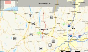
Route 179 is a state highway in northern Connecticut, running from Burlington to Hartland.
Route description
Route 179 begins at an intersection with Route 4 in eastern Burlington and heads north along the Farmington River into Canton. After crossing the Farmington River in Collinsville, it follows the Farmington River before intersecting with both US 202 and US 44 just west of the western end of the US 44/202 overlap. It continues north along Cherry Brook passing through Canton Center and meeting the western end of Route 309 before curving northwest in North Canton and entering Barkhamsted. In Barkhamsted, it heads northwest, then turns north, briefly overlapping Route 219 and continuing into Hartland. In Hartland, it continues north, to end at an intersection with Route 20 in East Hartland.[1]
A section of Route 179 in Canton from the Burlington town line to SR 565 is designated a scenic road.[1]
History
Route 179 was commissioned in 1932, running from US 44 in New Hartford to Route 20 in Hartland, along a route that is now generally but not completely assigned to Route 219. The original route used modern Route 219 from New Hartford center to the junction with modern Route 179, then Route 179 north to Hartland center. In 1944, Route 179 was relocated to its current route towards Canton Center, ending at its current intersection with US 44. Route 179 was also extended north to the Massachusetts state line at the same time. In 1963, with a realignment of Route 4, the former section of Route 4 from Canton to Burlington was reassigned to Route 179, ending at the current southern terminus. In 1979, the section north of Route 20 was redesignated as SR 819.[2]
Junction list
| County | Location | mi[1] | km | Destinations | Notes |
|---|---|---|---|---|---|
| Hartford | Burlington | 0.00 | 0.00 | ||
| Canton | 3.86 | 6.21 | |||
| 4.01 | 6.45 | ||||
| 8.77 | 14.11 | ||||
| Litchfield | Barkhamsted | 12.06 | 19.41 | Southern terminus of CT 219 overlap | |
| 12.12 | 19.51 | Northern terminus of CT 219 overlap | |||
| Hartford | Hartland | 16.50 | 26.55 | Northern terminus of CT 179 | |
1.000 mi = 1.609 km; 1.000 km = 0.621 mi
| |||||
References
- 1 2 3 4 Connecticut State Highway Log Archived 2015-07-26 at WebCite
- ↑ Connecticut Routes, Route 179