Simsbury, Connecticut
| Simsbury, Connecticut | ||
|---|---|---|
| Town | ||
| ||
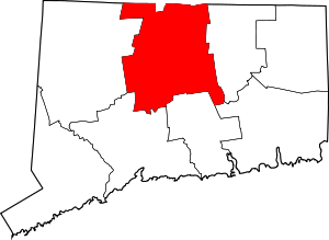
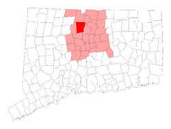 Location in Hartford County, Connecticut | ||
| Coordinates: 41°52′14″N 72°49′31″W / 41.87056°N 72.82528°WCoordinates: 41°52′14″N 72°49′31″W / 41.87056°N 72.82528°W | ||
| Country | United States | |
| State | Connecticut | |
| NECTA | Hartford | |
| Region | Capitol Region | |
| Named | 1670 | |
| Government | ||
| • Type | Selectman-town meeting | |
| • First selectman | Lisa Heavner (D) | |
| • Selectmen |
Sean P. Askham (R) Cheryl B. Cook (R) Mike R. Paine (R) Elaine Lang (D) Chris M. Kelly (D) | |
| Area | ||
| • Total | 34.3 sq mi (88.8 km2) | |
| • Land | 33.9 sq mi (87.9 km2) | |
| • Water | 0.4 sq mi (1.0 km2) | |
| Elevation | 233 ft (71 m) | |
| Population (2010) | ||
| • Total | 23,511 | |
| Time zone | Eastern (UTC-5) | |
| • Summer (DST) | Eastern (UTC-4) | |
| ZIP code | 06070, 06081, 06089, 06092 | |
| Area code(s) | 860 | |
| FIPS code | 09-68940 | |
| GNIS feature ID | 0213506 | |
| Website |
www | |

Simsbury is a suburban town in Hartford County, Connecticut, United States. The population was 23,513 at the 2010 census.[1] The town was incorporated as Connecticut's twenty-first town in May 1670. Simsbury was named the 4th best town in Connecticut on Connecticut Magazines list of top places to live 2013 and 9th best town to live in 2015 in the United States by Time magazine.[2]
Simsbury boasts a highly recognized educational system. In 2016 Simsbury High School ranked 4th best high school in CT by Niche[3] and 9th by U.S. News and World Report.[4] The suburb also houses multiple private schools including The Ethel Walker School, Westminster School, The Master's School, St. Mary's Elementary School, and The Cobb Montessori School.
Simsbury built the Simsbury Meadows Performing Arts Center in 2005.
History
Early history
At the beginning of the 17th century, the area today known as Simsbury was inhabited by indigenous peoples. The Wappinger were one of these groups, composed of eighteen bands, organized not as formally as a tribe, but more of an association, like the Delaware. These bands lived between the Hudson and Connecticut rivers. The Wappingers were one of the Algonquian peoples, a linguistic grouping which includes hundreds of tribes.[5] One of the Wappinger bands, the Massaco, lived near, but mostly west of what is now called the Farmington River, the area now known as Simsbury and Canton.[6] The river was called the Massaco by the native inhabitants. The term Massaco may refer to the indigenous peoples, the river itself, the village occupied by the indigenous peoples, and the land adjacent to the river.[7]
In 1633, Windsor was the second town in Connecticut settled by Europeans and the first English settlement (the first European settlement being Huys de Goede Hoop, established by the Dutch in the Hartford area as a frontier settlement for the New Netherland Colony ten years earlier). For some time, the area of Massaco was considered "an appendix to the towne of Windsor.[8]" Settlers in Windsor forested and farmed in the area, but did not come to Massaco permanently for a number of years. In 1642, the General Court [of the colony of Connecticut] ordered that:[9]
the Governor and Mr. Heynes shall have liberty to dispose of the ground uppon that parte of Tunxis River cauled Mossocowe, to such inhabitants of Wyndsor as they shall see cause.
Despite this order, there is no record that any settlements ensued immediately. Five years later the General Court issued another order:[10]
The Court thinks fitt that Massacoe be purchased by the Country, and that ther be a Comitte chosen to dispose of yt to such inhabitants of Wyndsor as by the shalbe judged meet to make improuement therof...
but there is no record of grants of land arising from this order.[11]
In 1643, John Griffin and Michael Humphrey started a tar and turpentine business in Windsor. A few years later, a Massaco Indian named Manahanoose started a fire which destroyed tar belonging to Griffin. The Court ordered the payment of "five hundred fathom of wampum" as compensation. Instead of cash payment, Manahanoose delivered a deed to the land at Massacoe. The deed was agreed to by Manahanoose as well as other Indians, identified as "the proprietors of Massaco".[12] In 1653, the General Court granted 50 acres (200,000 m2) of meadowland to Lieutenant Aaron Cook, 60 acres (240,000 m2) to John Bissell and 50 acres (200,000 m2) to Thomas Ford, all in Massacoe.[13]
White settlers were farming the land and harvesting tar and turpentine in the 1650s, but did not build permanent settlements until the following decade. Aaron Cook built one of the early homes in the area now known as Terry's Plain, and John Griffin built a home, possibly in 1664, the date associated with a deed to land in Massacoe.[14] The settlement of Massacoe continued in the late 1660s. The General Court awarded a land grant to John Griffin of two hundred acres in 1663. In 1664, a deed description indicated he had become a permanent inhabitant. By 1669, a survey revealed that there were thirteen permanent residents of Massacoe. One of those residents, John Case, was appointed to the position of constable.[15] This is the first recorded civil office held by residents of the area.[12]
Incorporation
In 1670, Case, along with Joshua Holcomb & Thomas Barber, presented a petition to the General Court, requesting that Massacoe become a town of the colony of Connecticut.[16] On May 12 of 1670, the General Court granted the petition, and ordered that the plantation should be called "Simmsbury". The boundaries at that time were Farmington on the south and Windsor on the east, with the extent of Simsbury running 10 miles (16 km) north of Farmington and 10 miles west of Windsor, although the northern border, subject to dispute with Massachusetts, would be resolved later.[17] This extent covers what is present-day Simsbury as well as Granby and Canton.
The precise origin of the name of the town is not known for certain. The town records covering the first ten years after incorporation were accidentally burned in 1680 and 1681. One possibility is that the name of Simsbury comes from the English town of Symondsbury.[18] Holcomb, one of the petitioners, originally came from Symondsbury. Another possibility is that the name was derived from Simon Wolcott. He was known familiarly as "Sim", and he was considered one of the prominent men of the town.[16]
King Philip's War
In 1675, rumors of unrest among the indigenous peoples began to surface. The rumors proved accurate, and in the summer, King Philip's War began, a war between a number of tribes and the English settlers. The war extended through parts of four colonies, with Simsbury on the western edge of the conflict. At the time, it was seen as a frontier settlement.[19] The conflict was largely over by August 1676, although it did not formally end until a treaty was signed in 1678.
The colony formed a Council of War. In the days leading up to the war, they ordered settlers to keep night watches, and to work in the fields in armed groups of at least six.[20] By the time of the colony's General Court meeting of October 14, 1675, the situation was considered serious enough that the court ordered the residents of Simsbury to move to safety in Windsor. The order read:
This Court orders, that the people of Simsbury shall have a week's time to secure themselves and their corn there, and at the end of the week from this date, the souldiers, now in garrison at Simsbury, shall be released their attendance there.— colony of Connecticut General Court, [21]
In March 1676, the town of Simsbury was first pillaged, then burned to the ground. This destruction is described as the most extensive of any event of any Indian War in New England.[22] The settlers remained in Windsor until the spring of 1677, at which time most moved back to Simsbury, although some never returned.[23]
Daniel Hayes
In 1707, Daniel Hayes, then aged twenty-two, was captured by the indigenous people and carried off to Canada. The capture was witnessed, and a rescue party raised, but the group did not catch up with the captors. He was tied up each night, and bound to saplings. It took thirty days to reach Canada, at which point Hayes was forced to run the gauntlet. Near the end of the gauntlet, he hid in a wigwam to avoid an attempted blow by a club. The woman in the wigwam declared that the house was sacred, and having lost a husband and son to a war, adopted Hayes as her son. He remained for several years, attending to the woman. Eventually, he was sold to a Frenchman, who learned that Hayes had skill as a weaver, so put him to work in that business. Hayes managed to earn enough to buy his freedom after two years. He then returned to Simsbury, settled down on a farm and married. He became prominent, both in civil affairs as well as the church at Salmon Brook (now Granby).[24]
First American colonies coins
The first unauthorized coins minted in the American colonies, and the first in Connecticut, were struck by Dr. Samuel Higley in 1737 from copper mined from his own mine. The coins, including the Trader's Currency Token of the Colony of Connecticut, were minted in North Simsbury, now called Granby.[25] These coins were made of pure copper, which is very soft. Consequently, there are very few in existence today. The first coins were inscribed with a value of three pence. Later versions carried the phrase "Value me as you please."[26]
From 1750 to Today

Geography

According to the United States Census Bureau, the town has a total area of 34.3 square miles (88.8 km2), of which 33.9 square miles (87.9 km2) is land and 0.39 square miles (1.0 km2), or 1.09%, is water.[1]
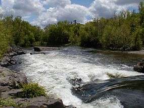
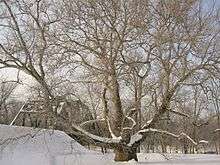
Simsbury lies in the northern end of the Farmington Valley. The east side of Simsbury is flanked by Talcott Mountain, part of the Metacomet Ridge, a mountainous trap rock ridgeline that stretches from Long Island Sound to nearly the Vermont border. Notable features of the Metacomet Ridge in Simsbury include Heublein Tower, Talcott Mountain State Park, Penwood State Park, and the Tariffville Gorge of the Farmington River. The 51-mile-long (82 km) Metacomet Trail traverses the ridge. At the western foot of the mountain, near the Farmington River, grows the Pinchot Sycamore, the largest tree in Connecticut.
Simsbury is roughly equidistant from both New York City (around 90 miles SW) and Boston, Massachusetts (around 90 miles ENE). The town is often considered a bedroom community for the nearby city of Hartford, Connecticut, a 35 to 40 minute drive from Simsbury Center, however many residents also commute to other towns and cities within the west-central Connecticut region.
Principal communities
There are four census-designated places in Simsbury: Simsbury Center, Tariffville, Weatogue, and West Simsbury.
Climate
| Climate data for Simsbury, Connecticut | |||||||||||||
|---|---|---|---|---|---|---|---|---|---|---|---|---|---|
| Month | Jan | Feb | Mar | Apr | May | Jun | Jul | Aug | Sep | Oct | Nov | Dec | Year |
| Record high °F (°C) | 72 (22) |
73 (23) |
89 (32) |
96 (36) |
99 (37) |
101 (38) |
102 (39) |
102 (39) |
101 (38) |
91 (33) |
83 (28) |
76 (24) |
102 (39) |
| Average high °F (°C) | 34 (1) |
39 (4) |
48 (9) |
61 (16) |
71 (22) |
80 (27) |
85 (29) |
83 (28) |
75 (24) |
63 (17) |
52 (11) |
40 (4) |
60.9 (16) |
| Average low °F (°C) | 18 (−8) |
21 (−6) |
28 (−2) |
38 (3) |
48 (9) |
57 (14) |
63 (17) |
61 (16) |
53 (12) |
41 (5) |
33 (1) |
23 (−5) |
40.3 (4.7) |
| Record low °F (°C) | −26 (−32) |
−24 (−31) |
−8 (−22) |
9 (−13) |
28 (−2) |
37 (3) |
44 (7) |
36 (2) |
27 (−3) |
17 (−8) |
1 (−17) |
−18 (−28) |
−26 (−32) |
| Average precipitation inches (mm) | 3.23 (82) |
3.00 (76.2) |
3.62 (91.9) |
3.72 (94.5) |
4.35 (110.5) |
4.35 (110.5) |
4.18 (106.2) |
3.93 (99.8) |
3.88 (98.6) |
4.37 (111) |
3.89 (98.8) |
3.44 (87.4) |
45.96 (1,167.4) |
| Source: [27] | |||||||||||||
Demographics
| Historical population | |||
|---|---|---|---|
| Census | Pop. | %± | |
| 1820 | 1,875 | — | |
| 1850 | 2,737 | — | |
| 1860 | 2,410 | −11.9% | |
| 1870 | 2,051 | −14.9% | |
| 1880 | 1,830 | −10.8% | |
| 1890 | 1,874 | 2.4% | |
| 1900 | 2,094 | 11.7% | |
| 1910 | 2,537 | 21.2% | |
| 1920 | 2,958 | 16.6% | |
| 1930 | 3,625 | 22.5% | |
| 1940 | 3,941 | 8.7% | |
| 1950 | 4,822 | 22.4% | |
| 1960 | 10,138 | 110.2% | |
| 1970 | 17,475 | 72.4% | |
| 1980 | 21,161 | 21.1% | |
| 1990 | 22,023 | 4.1% | |
| 2000 | 23,234 | 5.5% | |
| 2010 | 23,511 | 1.2% | |
| Est. 2014 | 23,975 | [28] | 2.0% |
As of the census[30] of 2000, there were 23,234 people, 8,527 households, and 6,591 families residing in the town. The population density was 685.7 people per square mile (264.8/km²). There were 8,739 housing units at an average density of 257.9 per square mile (99.6/km²). The racial makeup of the town was 95.3% White, 1.17% African American, 0.09% Native American, 2.12% Asian, 0.03% Pacific Islander, 0.26% from other races, and 1.03% from two or more races. Hispanic or Latino of any race were 1.54% of the population. The ethnic make-up of the town in terms of percentage of total residents (the five most common, ordered from most-reported to least) is Irish (23.0%), English (17.4%), German (15.6%), Italian (13.7%), and Polish (7.6%).[31]
There were 8,527 households out of which 41.1% had children under the age of 18 living with them, 69.1% were married couples living together, 6.4% had a female householder with no husband present, and 22.7% were non-families. 19.4% of all households were made up of individuals and 7.8% had someone living alone who was 65 years of age or older. The average household size was 2.70 and the average family size was 3.12.
In the town the population was spread out with 29.5% under the age of 18, 3.6% from 18 to 24, 27.7% from 25 to 44, 26.6% from 45 to 64, and 12.5% who were 65 years of age or older. The median age was 40 years. For every 100 females there were 94.6 males. For every 100 females age 18 and over, there were 89.3 males.
The median income for a household in the town was $120,432, and the median income for a family was $155,769 (as of a 2011estimate[32]). Males had a median income of $89,519 versus $42,136 for females. The per capita income for the town was $54,711. About 1.0% of families and 2.2% of the population were below the poverty line, including 1.6% of those under age 18 and 4.3% of those age 65 or over.
Economy
Top employers
According to Simsbury's 2011 Comprehensive Annual Financial Report,[33] the top employers in the city are:
| # | Employer | # of Employees |
|---|---|---|
| 1 | The Hartford | |
| 2 | Simsbury Public Schools | 732 |
| 3 | McLean Care | 457 |
| 4 | Chubb | 406 |
| 5 | Ensign-Bickford Company | 233 |
| 6 | Super Stop & Shop | 170 |
| 7 | Town of Simsbury | 146 |
| 8 | Hoffman Auto Group | 144 |
| 9 | Mitchell Auto Group | 110 |
| 10 | Hopmeadow Country Club | 100 |
Landmarks
- The Ethel Walker School, Master's School, St. Mary's School, and Westminster School are private schools in Simsbury.
- The International Skating Center of Connecticut
- Three of the four state parks in Hartford County, Penwood State Park, Stratton Brook State Park, and Talcott Mountain State Park, are in town.
- Simsbury Airport is a public use airport located in Simsbury and East Granby.
- Ensign-Bickford Industries, founded in Simsbury in 1836, is still headquartered in town.
- The Pinchot Sycamore, an American sycamore located in town, is the largest tree in Connecticut. According to a measurement made in 1998, the tree was 26 feet (7.9 m) around and 95 feet (29 m) tall, with an average canopy diameter of 140 feet (43 m).
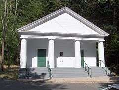
On the National Register of Historic Places
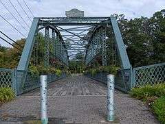
- Drake Hill Road Bridge—Drake Hill Rd. at Farmington River (added August 19, 1984). The Drake Hill Bridge is a pin-connected Parker truss, built in 1892 over the Farmington River. The bridge has a 12-foot (3.7 m) roadway and a span of 183 feet (56 m). It originally carried vehicle traffic but now is open for foot and bicycle traffic. This bridge is one of only three surviving Parker trusses in Connecticut.[34]
- East Weatogue Historic District—Roughly, properties on East Weatogue St. from just north of Riverside Dr. to Hartford Rd., and Folly Farm property to south (added 1990)
- Heublein Tower—Talcott Mountain State Park (added 1983)
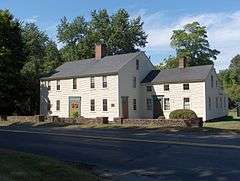
- John Humphrey House—115 E. Weatogue St. (added 1990) The John Humphrey House is a Colonial two-story frame house, built approximately 1760. The estimate of the building date comes partially from land records, and partially from the location of the bake oven in the kitchen.[35]
- Massaco Forest Pavilion—Off Farms Village Rd., Stratton Brook State Park (added 1986)
- Simsbury Center Historic District—Roughly, Hopmeadow St. from West St. to Massaco St. (added 1996)
- Amos Eno House—Off U. S. 202 on Hopmeadow Rd. (added 1975) Also, known as the Simsbury House or the 1820 House, this house was built by Elisha Phelps but named after Amos Eno, who used it as a summer residence for many years.
- Eno Memorial Hall—754 Hopmeadow St. (added 1993)
- Horace Belden School (now the Town Hall/Police Station) and Central Grammar School—933 Hopmeadow St. and 29 Massaco St. (added 1993)
- Robert and Julia Darling House—720 Hopmeadow St. (added 1991)
- Capt. Elisha Phelps House (also known as "Phelps Tavern Museum & Homestead")—800 Hopmeadow St., a 1771 house used as a tavern from 1786 to 1849 (added 1972)
- Simsbury Bank and Trust Company Building—760–762 Hopmeadow St. (added 1986)
- Simsbury Railroad Depot—Railroad Ave. at Station St. (added 1976)
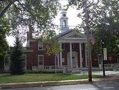
- Simsbury Townhouse—695 Hopmeadow St. (added 1993) The Simsbury Townhouse was the original town hall for the town of Simsbury, used as a town hall for almost 100 years. It was originally built in 1839, at the top of the hill near its present location, and moved, possibly in 1843, and finally in 1869. The wooden structure was constructed in the Greek Revival style.[36]
- Tariffville Historic District—Roughly bounded by Winthrop St., Main St., Tunxis Rd., Mountain Rd., and Elm St. (added 1993)
- Terry's Plain Historic District—Roughly bounded by Pharos, Quarry and Terry's Plain Rds. and the Farmington R. (added 1993)
Notable people
Skaters
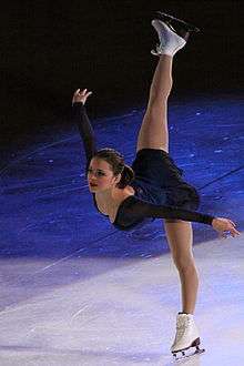
- Shizuka Arakawa (荒川 静香) (born 1981), Japanese figure skater who won the gold medal at the 2006 Winter Olympics, has trained at the International Skating Center of Connecticut in town
- Oksana Baiul (born 1977), 1994 Olympic champion lived and trained in Simsbury after winning her title[37]
- Sasha Cohen (born 1984), 2006 U.S. National Champion figure skater and silver medalist at the 2006 Olympics, trained in Simsbury with Russian coach Tatiana Tarasova, starting in summer 2002
- Ekaterina Gordeeva (born 1971), winner of two Olympic gold medals (1988 and 1994), moved to Simsbury in the 1990s[37]
- Michelle Kwan (born 1980), Olympic figure skater, has trained at the International Skating Center of Connecticut
- Viktor Petrenko (born 1969), 1992 Olympic champion, trained in Simsbury beginning in 1994[37]
- Alexei Yagudin (born 1980), 2002 Olympic champion and four time world champion, lived and trained in Simsbury from 1998 to 2005 with Tatiana Tarasova
Others
- James Adams (1783–1843)- Lawyer and early convert to Mormonism
- Parmenio Adams (1776–1832), former US Congressman
- Levi Barber (1777–1833), U.S. Representative from Ohio[38]
- Lucius Israel Barber (1806–1889), Wisconsin Territory politician
- Lake Bell (born 1979), actress, attended school in Simsbury
- Sean Burke (born 1967), NHL goalie (former Hartford Whaler)
- Vince Cazzetta (1925–2005), head coach for the Pittsburgh Pipers
- Terry Deitz (born 1959), Survivor contestant and host of Great Planes on the Military Channel.
- Rob Dibble (born 1964), former MLB player
- Sherri Browning Erwin (1968–present), author and current resident.
- Justin Foley (born 1976), drummer, Killswitch Engage and Blood Has Been Shed
- Sarah Pratt McLean Greene (1856-1935), novelist, born in Simsbury.[39]
- Sara Hendershot (born 1988), member of 2012 United States Olympic Rowing Team (W2-)
- Samuel Higley (1687-1737), reputed to have coined the first copper coins ("Higley coppers") in the colonial United States.
- Paul Holmgren (born 1955), Former coach of the Hartford Whalers and current president of the Philadelphia Flyers.
- Martin Luther King, Jr. (1929–1968), worked on a tobacco farm in Simsbury during the summers of 1944 and 1947 to earn money for college[40]
- George McLean (1857–1932), U.S. senator and Simsbury resident who founded the 4,200-acre (17 km2) McLean Game Refuge in town[41]
- Elisha Phelps (1779–1847), congressman from Connecticut[42]
- Gifford Pinchot (1865–1946), first Chief of the United States Forest Service (1905–1910), Governor of Pennsylvania (1923–1927, 1931–1935), born in Simsbury[43]
- Sigourney Weaver (born 1949), actress, attended Ethel Walker School in Simsbury
- Jennifer Weiner (born 1970), author
Public safety
Law enforcement is provided by the Simsbury Police Department.
Fire protection is provided by the Simsbury Volunteer Fire Company. The Fire Company has six stations located throughout the town and a dispatch center housed at the Main Station. The Fire Company has seven engines, two aerials, two rescues, a tanker, two marine units, a hazmat unit, a brush truck, a special command vehicle and several utility vehicles. In addition to fire suppression and vehicle extrication, the Fire Company provides high-angle, confined-space and ice rescue services, and is a member of the Capital Region HazMat Response Team.
Emergency medical services are provided by the Simsbury Volunteer Ambulance Association. The Association has a primary ambulance staffed twenty-four hours a day by volunteer EMTs. There is a secondary ambulance that is staffed with paid personnel during peak hours and can also be staffed by off-duty personnel for calls when the primary ambulance is out. SVAA also has a paramedic response unit staffed around the clock by a career paramedic, providing the residents of Simsbury with the highest level of emergency medical care. The organization has 8 paramedics and 43 active EMTs. In addition to being the primary EMS responder in town, SVAA also does stand-bys at public events and holds first aid/CPR courses throughout the year, as well as an annual EMT-Basic course.
Simsbury Public Library
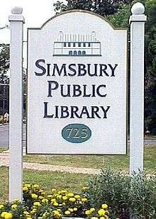
The Simsbury Public Library serves more than 800 residents daily and offers many programs and services including homebound delivery, public computers, a museum pass program, a Business Resource Center, and 24/7 reference assistance. The library can trace its history back to 1872 as the Town’s Social and Literary Club. In 1890 the town built a library as part of the Town’s center and it operated until the present library was constructed nearby in 1985. The library held a grand opening to celebrate the renovated library in June 2008.[44] In the year ending June 30, 2006, the library maintained a collection of 163,000 print, audio, and video items, offered the contents of 40 databases, circulated 436,000 items, answered 57,000 requests for information, and offered 756 programs to the various constituencies that the Library serves.[45]
In the last five years, the Simsbury Public Library has ranked among the top five of Connecticut's public libraries according to Hennen's American Public Library Ratings. In 2002, it ranked among the top 100 in the country (out of 9,000).[46] In 2008 the Simsbury Public Library expanded with a new addition.
Schools
Public high schools
- Simsbury High School (Students: 1,457; Location: 34 Farms Village Rd.; Grades: 09 – 12)
Private high schools
- Westminster School (Students: 353; Location: 995 Hopmeadow Street; Grades: 9 – 12)
- Ethel Walker School (Students: 252; Location: 230 Bushy Hill Road; Grades: 7 – 12; Girls only)
- The Master's School (Students: 400; Location: 36 Westledge Road; Grades PK – 12)
Public primary/middle schools
- Central School (Students: 479; Location: 29 Massaco St.; Grades: PK – 06)
- Latimer Lane School (Students: 623; Location: 33 Mountain View Rd.; Grades: KG – 06)
- Squadron Line School (Students: 849; Location: 44 Squadron Line Rd.; Grades: KG – 06)
- Tariffville School (Students: 280; Location: 42 Winthrop St.; Grades: KG – 06)
- Tootin' Hills School (Students: 537; Location: 25 Nimrod Rd.; Grades: KG – 06)
- Henry James Memorial School (Students: 840; Location: 155 Firetown Rd.; Grades: 07 – 08)
& Homebound (Location: 933 Hopmeadow Street; Grades: PK – 12)
Private primary/middle schools
- St. Mary's School (Students: 264; Location: 946 Hopmeadow Street; Grades: K – 8)
- The Cobb School Montessori (Students: 145; Location: 112 Sand Hill Rd.; Grades: PK – 5)
Sister cities
-
 Wittmund, Germany
See also
Notes
- 1 2 "Geographic Identifiers: 2010 Demographic Profile Data (G001): Simsbury town, Hartford County, Connecticut". U.S. Census Bureau, American Factfinder. Retrieved November 28, 2012.
- ↑ http://time.com/money/3984414/simsbury-connecticut-best-places-to-live-2015/
- ↑ https://k12.niche.com/rankings/public-high-schools/best-overall/s/connecticut/
- ↑ "Simsbury High school". U.S. World and News Report. Retrieved November 7, 2016.
- ↑ Trelease, p. 4–9.
- ↑ "New York Indian Tribes". Access Genealogy.com. Retrieved September 29, 2010.
- ↑ "Phelps Family History in America". Phelps Family History. Retrieved September 30, 2010.
- ↑ Connecticut 1852, p. 97.
- ↑ Connecticut 1850, p. 71.
- ↑ Connecticut 1850, p. 161.
- ↑ Phelps, p. 10.
- 1 2 Trumbull, p. 342.
- ↑ Connecticut 1850, p. 247.
- ↑ Phelps, p. 12.
- ↑ Connecticut 1852, p. 118.
- 1 2 Trumbull, p. 343.
- ↑ Connecticut 1852, p. 127.
- ↑ Fry, CR. "Simsbury, USA, and Symondsbury, Dorset: Holcomb and Wolcott Connections? The Greenwood Tree. Vol.32, No.3, 2007
- ↑ Phelps, p. 21.
- ↑ Phelps, p. 20.
- ↑ Connecticut 1852, p. 269.
- ↑ Phelps, p. 24.
- ↑ Phelps, p. 25.
- ↑ Phelps, p. 37–44.
- ↑ Federal Writers' Project. Connecticut: A Guide to Its Roads, Lore and People. US History Publishers. p. 58. ISBN 978-1-60354-007-0. Retrieved September 23, 2010.
- ↑ American Numismatic Society (1897). Proceedings of the American Numismatic and Archeological Society. p. 16. Retrieved October 20, 2010.
- ↑ "Monthly Averages for Simsbury, CT (06070)". Weather.com. Retrieved November 22, 2011.
- ↑ "Annual Estimates of the Resident Population for Incorporated Places: April 1, 2010 to July 1, 2014". Retrieved June 4, 2015.
- ↑ "Census of Population and Housing". Census.gov. Retrieved June 4, 2015.
- ↑ "American FactFinder". United States Census Bureau. Retrieved 2008-01-31.
- ↑ "Simsbury, Connecticut". City-Data. Retrieved May 21, 2013.
- ↑ http://factfinder.census.gov/servlet/ADPTable?_bm=y&-context=adp&-qr_name=ACS_2007_3YR_G00_DP3YR3&-ds_name=ACS_2007_3YR_G00_&-tree_id=3307&-redoLog=true&-_caller=geoselect&-geo_id=06000US0900368940&-format=&-_lang=en
- ↑ Town of Simsbury CAFR
- ↑ "Drake Hill Road Bridge" (PDF). National Register of Historic Places. Retrieved September 20, 2010.
- ↑ "John Humphrey House" (PDF). National Register of Historic Places. Retrieved September 20, 2010.
- ↑ "Simsbury Townhouse" (PDF). National Register of Historic Places. Retrieved September 20, 2010.
- 1 2 3 Rabinovitz, Jonathan (February 2, 1997). "When Olympic Champions Moved In, They Put Simsbury on the World Map". The New York Times. Simsbury, Connecticut. Retrieved January 4, 2011.
- ↑ "BARBER, Levi, (1777 - 1833)". Biographical Directory of the United States Congress. Retrieved December 21, 2012.
- ↑ James, Edward T., et al. Notable American Women, 1607-1950: A Biographical Dictionary, vol. 2, p. 86.
- ↑ The Autobiography of Martin Luther King Jr. p. 11. Edited by Clayborne Carson, 1998.
- ↑ "McLEAN, George Payne, (1857 - 1932)". Biographical Directory of the United States Congress. Retrieved December 21, 2012.
- ↑ "PHELPS, Elisha, (1779 - 1847)". Biographical Directory of the United States Congress. Retrieved December 21, 2012.
- ↑ "* Pennsylvania Governor Gifford Pinchot". National Governors Association. Retrieved January 24, 2013.
- ↑ "2007–2008 Annual Report" (PDF). 2007–2008 Annual Report. p. 13. Retrieved September 21, 2010.
- ↑ Town of Simsbury, Annual Report 2005–2006. Simsbury, CT: May 2007.
- ↑ Hennen Jr., Thomas J. Hennen's American Public Library Ratings:HAPLR 100 for 1999 to 2006
References
- Allen W. Trelease (January 1, 1997). Indian affairs in colonial New York: the seventeenth century. U of Nebraska Press. ISBN 978-0-8032-9431-8. Retrieved September 29, 2010.
- Connecticut (1852). The public records of the colony of Connecticut [1636–1776] ...: transcribed and published, (in accordance with a resolution of the general assembly) ... Brown & Parsons. Retrieved September 26, 2010.
- Connecticut (1850). The public records of the colony of Connecticut [1636–1776] ... Press of the Case. Retrieved September 30, 2010.
- Phelps, Noah Amherst (1845). History of Simsbury, Granby, and Canton; from 1642 To 1845. Hartford: Press of Case, Tiffany and Burnham.
- J. Hammond Trumbull (2009). The Memorial History of Hartford County Connecticut 1633–1884. BiblioBazaar, LLC. ISBN 978-1-115-33123-4. Retrieved October 1, 2010.
External links
* Simsbury Meadows Performing Arts Center