Farmington, Connecticut
| Farmington, Connecticut | ||
|---|---|---|
| Town | ||
| ||
| Motto: "Respecting History, Planning The Future"[1] | ||
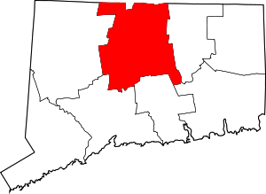
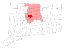 Location in Hartford County, Connecticut | ||
| Coordinates: 41°43′40″N 72°50′25″W / 41.72778°N 72.84028°WCoordinates: 41°43′40″N 72°50′25″W / 41.72778°N 72.84028°W | ||
| Country | United States | |
| State | Connecticut | |
| NECTA | Hartford | |
| Region | Capitol Region | |
| Settled | 1641 | |
| Incorporated | 1645 | |
| Consolidated | 1947 | |
| Government | ||
| • Type | Council-manager | |
| • Town Council |
Nancy Nickerson (R), Chm Jeffrey P. Apuzzo (R) Jon Landry (R) Peter Mastrobattista (R) Meredith A. Trimble (R) Amy Suffredini (D) John W. Vibert (D) | |
| Area | ||
| • Total | 28.8 sq mi (74.5 km2) | |
| • Land | 28.0 sq mi (72.6 km2) | |
| • Water | 0.8 sq mi (2.0 km2) | |
| Elevation | 161 ft (49 m) | |
| Population (2010) | ||
| • Total | 25,340 | |
| • Density | 880/sq mi (340/km2) | |
| Time zone | Eastern (UTC-5) | |
| • Summer (DST) | Eastern (UTC-4) | |
| ZIP code | 06032, 06085 | |
| Area code(s) | 860 | |
| FIPS code | 09-27600 | |
| GNIS feature ID | 0213430 | |
| Website |
www | |
Farmington is a town located in Hartford County in the Farmington Valley area of central Connecticut in the United States. The population was 25,340 at the 2010 census.[2] As an affluent suburb of Hartford, it is home to the world headquarters of several large corporations including Carrier Corporation, Otis Elevator Company, and Carvel.
History
Eighteenth and nineteenth centuries
| Town | Date of separation |
|---|---|
| Southington | 1779 |
| Berlin | 1785 |
| Bristol | 1785 |
| Wolcott (eastern part) | 1796 |
| Burlington | 1806 |
| Avon (as Northington) | 1845 |
| New Britain | 1850 |
| Plainville | 1869 |
Farmington was originally inhabited by the Tunxis Indian tribe. In 1640, a community of English immigrants was established by residents of Hartford, making Farmington the oldest inland settlement west of the Connecticut River and the twelfth oldest communities in the state. Settlers found the area ideal because of its rich soil, location along the floodplain of the Farmington River, and valley geography.
The town and river were given their present names in 1645, which is considered the incorporation year of the town. The town's boundaries were later enlarged several times, making it the largest in the Connecticut Colony. The town was named after Farmington, in England.[3]
Farmington has been called the "mother of towns" because its vast area was divided to produce nine other central Connecticut communities. The borough of Unionville, in Farmington's northwest corner, was once home to many factories harnessing the water power of the Farmington River.
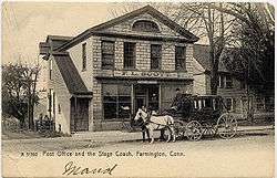
Farmington is steeped in New England history. Main Street, in the historic village section, is lined with colonial estates, some of which date back to the 17th century. During the Revolutionary War, George Washington passed through Farmington on several occasions and referred to the town as "the village of pretty houses."[4] In addition, French troops under General Rochambeau encamped in Farmington en route to Westchester County to offer crucial support to General Washington's army.
Nineteenth century

The majority of Farmington residents were abolitionists and were active in aiding escaped slaves. Several homes in the town were "safe houses" on the Underground Railroad. The town became known as "Grand Central Station"[5][6] among escaped slaves and their "guides".
Farmington played an important role in the famous Amistad trial. In 1841, 38 Mende Africans and Cinqué, the leader of the revolt on the Amistad slave ship, were housed and educated in Farmington after the U.S. government refused to provide for their return to Africa following the trial. The Mende were educated in English and Christianity while funds were raised by residents for their return to Africa.
The Farmington Canal, connecting New Haven with Northampton, Massachusetts, passed through the Farmington River on its eastern bank and was in operation between 1828 and 1848. The canal's right of way and towpath were eventually used for a railroad, portions of which were active up to the 1990s. Part of the canal and railroad line has now been converted to a multi-use trail.
Important institutions in town
Just above the village, off Mountain Road, lies the Hill-Stead Museum. The estate, completed in 1901 and designed for Alfred Atmore Pope by his daughter Theodate Pope Riddle, one of the first woman American architects, is known for its Colonial Revival architecture. Now a museum, its 19 rooms hold a nationally-recognized collection of Impressionist paintings by such masters as Manet, Monet, Whistler, Degas and Cassatt. It is the site of the annual Sunken Garden Poetry Festival and is a National Historic Landmark.
Miss Porter's School, an exclusive college preparatory school for girls, is in Farmington. The school, whose buildings occupy much of the village center, is a significant historic and cultural institution in its own right. Founded in 1843 by educational reformer Sarah Porter, Miss Porter's has long been one of the most selective preparatory schools for girls in the country. Famous alumni include Jacqueline Kennedy Onassis, Lilly Pulitzer and members of the Bush, Vanderbilt, and Rockefeller families.
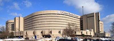
The town is home to the University of Connecticut Health Center, which employs over 5,000 people. The Health Center also houses John Dempsey Hospital. The hospital provides the only full-service emergency department in the Farmington Valley and a Level III Neonatal Intensive Care Unit (NICU), one of only two in Connecticut.
Farmington is home to TRUMPF Inc., the largest manufacturer of fabricating machinery in the United States and a world market leader in lasers used for industrial production technology.
Development issues
Many residents have repeatedly fought proposals by the state to widen Route 4, a main thoroughfare linking northwestern Connecticut to Interstate 84, fearing that such a move would compromise the character and integrity of the town. With the recent relocation of Parsons Chevrolet, "on that crazy corner" just above the village, there is some suspicion that this widening of Route 4 will come sooner rather than later. Work has been delayed because of the town's fight to maintain the village aesthetic and requests for modifications to the proposed plan.
Farmington faces a relatively strong demand for housing. The lure of Farmington's quality public school system, convenient location for commuters, charm, and name recognition continue to attract new home buyers. As such, town officials are faced with the task of accommodating new growth while respecting the preservation and need for open space. Farmington's real estate values are among the highest in Greater Hartford.
In January 2008, town residents overwhelmingly approved the purchase of nearly 100 acres (0.40 km2) of farmland. This blocked a proposal to convert the farm into a residential strip, something many feared would have compromised the town's rural feel.
Geography
According to the United States Census Bureau, the town has a total area of 28.8 square miles (74.5 km2), of which 28.0 square miles (72.6 km2) is land and 0.77 square miles (2.0 km2), or 2.65%, is water.[2]
After its founding, Farmington gave up territory to form Southington (1779), Bristol (1785), Avon (1830), Plainville (1869), and parts of Berlin (1785) and Bloomfield (1835).[7] Farmington presently borders the towns of Avon, Burlington, Newington, West Hartford, and Plainville, and the cities of New Britain and Bristol.
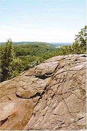
Farmington is mostly wooded, but there are also meadows and hills in the east and southeast. There are also numerous ponds and lakes. The Farmington River runs through the town from the northwest from Burlington, enters Unionville, then takes a sharp turn near Farmington Center and flows north towards Avon. The Metacomet Ridge, a 100-mile (160 km) range of low traprock mountain ridges, occupies the east side of Farmington as Pinnacle Rock, Rattlesnake Mountain, Farmington Mountain, and Talcott Mountain. The ridge is traversed by the 51-mile-long (82 km) Metacomet Trail, a hiking trail, and contains several rock walls and chimneys suitable for technical climbing in places such as Pinnacle Rock and the Green Wall. These climbing areas, as well as several other rock climbing locations in central Connecticut, are documented in the 1995 book Hooked on Traprock.[8]
Demographics
| Historical population | ||
|---|---|---|
| Year | Pop. | ±% |
| 1756 | 3,707 | — |
| 1774 | 6,069 | +63.7% |
| 1782 | 5,542 | −8.7% |
| 1790 | 2,696 | −51.4% |
| 1800 | 2,809 | +4.2% |
| 1810 | 2,748 | −2.2% |
| 1820 | 3,042 | +10.7% |
| 1830 | 1,901 | −37.5% |
| 1840 | 2,041 | +7.4% |
| 1850 | 2,630 | +28.9% |
| 1860 | 3,144 | +19.5% |
| 1870 | 2,616 | −16.8% |
| 1880 | 3,017 | +15.3% |
| 1890 | 3,179 | +5.4% |
| 1900 | 3,331 | +4.8% |
| 1910 | 3,478 | +4.4% |
| 1920 | 3,844 | +10.5% |
| 1930 | 4,548 | +18.3% |
| 1940 | 5,313 | +16.8% |
| 1950 | 7,026 | +32.2% |
| 1960 | 10,813 | +53.9% |
| 1970 | 14,390 | +33.1% |
| 1980 | 16,407 | +14.0% |
| 1990 | 20,608 | +25.6% |
| 2000 | 23,641 | +14.7% |
| 2010 | 25,340 | +7.2% |
| Source: Interactive Connecticut State Register & Manual and U.S. Census Bureau, Population Division | ||
As of the census[9] of 2010, there were 25,340 people, 9,496 households, and 6,333 families residing in the town. The population density was 879.9 people per square mile (339.7/km²). There were 11,072 housing units at an average density of 351.2 per square mile (135.6/km²). The racial makeup of the town was 85.92% White, 2.21% African American, 0.04% Native American, 9.59% Asian, 0.49% from other races, and 2.43% from two or more races. Hispanic or Latino of any race were 2.98% of the population.[10]
There were 10,522 households out of which 29.6% had children under the age of 18 living with them, 53.7% were married couples living together, 8.0% had a female householder with no husband present, and 35.7% were non-families. 29.6% of all households were made up of individuals. The average household size was 2.38 and the average family size was 3.00.
In the town, the population was spread out with 22.0% under the age of 18, 4.7% from 18 to 24, 29.7% from 25 to 44, 25.7% from 45 to 64, and 15.5% who were 65 years of age or older. The median age was 40 years. For every 100 females there were 90.0 males. For every 100 females age 18 and over, there were 85.3 males.
The mean income for a household in town is $133,156, and the mean income for a family is $159,834[11]). Males had a median income of $80,182 versus $61,098 for females. The per capita income for the town was $54,754. About 3.1% of families and 5.8% of the population were below the poverty line, including 3.9% of those under age 18 and 6.3% of those age 65 or over.
| Voter Registration and Party Enrollment as of October 28, 2008[12] | |||||
|---|---|---|---|---|---|
| Party | Active Voters | Inactive Voters | Total Voters | Percentage | |
| Democratic | 5,579 | 186 | 5,765 | 31.96% | |
| Republican | 4,467 | 172 | 4,639 | 25.72% | |
| Unaffiliated | 7,229 | 380 | 7,609 | 42.18% | |
| Minor Parties | 21 | 6 | 27 | 0.15% | |
| Total | 17,296 | 744 | 18,040 | 100% | |
Economy
Farmington is home to a significant and growing number of corporations. Carvel, ConnectiCare, Farmington Bank, and Horizon Technology Finance all maintain their corporate headquarters in Farmington. United Technologies has significant operations in town as its subsidiaries Carrier Corporation, Otis Elevator and UTC Fire & Security are headquartered in town. Other prominent employers include the American Red Cross, Bank of America, McKesson, Stanley Black & Decker and Trumpf Inc.
The Jackson Laboratory of Bar Harbor, Maine, is building a new facility on the grounds of the University of Connecticut Health Center, which specializes in the research and development of genomic medicine. The project is part of BioScience Connecticut, an initiative designed to launch Connecticut into the forefront of biomedical research.
Farmington is unique in that more people work within the town lines than actually live there, a characteristic atypical of a traditional suburb.
On the National Register of Historic Places
- Austin F. Williams Carriagehouse and House — 127 Main Street (added 1998)
- Farmington Historic District — Porter and Mountain Rds., Main and Garden Sts., Hatter's and Hillstead Lanes, and Farmington Ave. (added 1972)
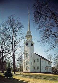
- First Church of Christ — 75 Main St. (added 1975)
- Gen. George Cowles House — 130 Main St. (added 1982)
- Gridley-Parsons-Staples Homestead — 1554 Farmington Ave. (added 1981)
- Hill-Stead Museum — 35 Mountain Rd. (added 1991)
- Pequabuck Bridge — Meadow Rd. at Pequabuck River (added 1984)
- Shade Swamp Shelter — US 6 E of New Britain Ave. (added 1986)
- Stanley-Whitman House — 37 High St. (added November 15, 1966)
- West End Library — 15 School St., Unionville (added 2000)
Education
Students in Farmington have access to public schools that consistently rank among the best in the nation. The town has seven main public schools. The four K-4 elementary schools are Union School, West District School, Noah Wallace School, and East Farms School. The recently built West Woods Upper Elementary School houses all of grades 5-6 and features state of the art facilities. Irving A. Robbins Middle School houses grades 7-8. Farmington High School serves grades 9-12 for the entire town. In 2005, Farmington High School was ranked 125 on Newsweek Magazine's list of the best schools in the United States,[13] in 2006 Farmington was ranked 269[14] and in 2007, 298.[15]
Notable people
- Curtis Jackson, hip hop rapper and entrepreneur, more commonly known as 50 Cent[16]
- Tim Abromaitis, former Notre Dame Basketball star, twice named a first team Academic All-American, the first player to be named Big East Conference Scholar-athlete of the Year three times. Currently playing basketball professionally for Basketball Löwen Braunschweig in Germany.[17]
- Steve Addazio Boston College Head Football Coach[18]
- Richard M. Bissell, Jr., Central Intelligence Agency officer responsible for the U-2 spy plane project and the Bay of Pigs Invasion[19]
- Nick Bonino, NHL hockey player[20]
- Anna Roosevelt Cowles, eldest sister of President Theodore Roosevelt and aunt of Eleanor Roosevelt[21]
- Kevin Galvin, business and health care advocate[22]
- Michael Gladis, actor, raised in Farmington and graduated from Farmington High School[23]
- George Gleason, Wisconsin State Assemblyman[24]
- Orville Hungerford, U.S. Congressman[25]
- Tebucky Jones, former New England Patriots football player
- Jacqueline Bouvier Kennedy, resided in Farmington while a student at Miss Porter's School[26]
- Chauncey Langdon, U.S. congressman from Vermont, born in Farmington[27]
- Timothy Merrill, Secretary of State of Vermont[28]
- Erin Pac, U.S. Olympic Women's bobsled team and Two-Woman Bobsled Event bronze medalist at the 2010 Winter Olympics[29]
- Alfred Atmore Pope, industrialist and art collector, resided at Hill-Stead from 1901-1913. Father of Theodate Pope Riddle[30]
- Theodate Pope Riddle, noted female architect and founder of Hill-Stead Museum[31]
- Pawel Szajda, actor, born and raised in Farmington, graduated from Farmington High School[32]
- Kristen Taekman, model and castmember of The Real Housewives of New York City, born and raised in Farmington
- John Treadwell, fourth governor of the state of Connecticut.[33]
- Mike Tyson, former resident. In 2004, 50 Cent bought Tyson's 18-acre (73,000 m2) compound, which is located about 2 miles (3.2 km) southeast from the town center.[34]
- Suzy Whaley, the first female golfer to qualify for a PGA event. Currently the President of the LPGA.[35]
- Wilford Woodruff, fourth president of The Church of Jesus Christ of Latter-day Saints (LDS Church), born in Farmington[36]
- Aric Rindfleisch, Professor of Business Administration and Department Head at College of Business at Illinois[37]
See also
- Eli Todd
- Farmington Canal
- Farmington High School (Connecticut)
- Hill-Stead Museum
- Metacomet Ridge
- Metacomet Trail
- Miss Porter's School
- Tunxis Community College
- Primacy (company)
References
- ↑ "Town of Farmington Connecticut". Town of Farmington Connecticut. Retrieved September 22, 2012.
- 1 2 "Geographic Identifiers: 2010 Demographic Profile Data (G001): Farmington town, Hartford County, Connecticut". U.S. Census Bureau, American Factfinder. Retrieved November 26, 2012.
- ↑ Gannett, Henry (1905). The Origin of Certain Place Names in the United States. Govt. Print. Off. p. 124.
- ↑ Glasberg, Eve (2006-03-03). "A 'Village of Pretty Houses,' Where Women's Lives Were Reshaped". The New York Times. The New York Times Company. Retrieved 2007-03-15.
- ↑ "Underground Railroad, Black History Freedom Trail and Amistad Sites Tour in Farmington". Heritage Trails Sightseeing Tours. Retrieved September 20, 2010.
- ↑ "History of Farmington". Farmington Historical Society. Retrieved September 20, 2010.
- ↑ Barry, Ann P. “Connecticut Towns and Their Establishment.” Hartford, CT: Connecticut State Library, Archives, History, and Genealogy Unit, 1985.
- ↑
- ↑ "American FactFinder". United States Census Bureau. Retrieved 2008-01-31.
- ↑ "Farmington, Connecticut fact sheet". American Fact Finder. United States Census Bureau. 2010. Retrieved 2007-03-06.
- ↑ http://factfinder.census.gov/servlet/ACSSAFFFacts?_event=Search&geo_id=&_geoContext=&_street=&_county=farmington&_cityTown=farmington&_state=04000US09&_zip=&_lang=en&_sse=on&pctxt=fph&pgsl=010
- ↑ "Registration and Party Enrollment Statistics as of October 28, 2008" (PDF). Connecticut Secretary of State. Retrieved 2009-04-05.
- ↑ Bondy, Halley; Brillman, Dan; Kaufman, Becca. "The Top of the Class". Newsweek. MSNBC. Archived from the original on 2007-06-25. Retrieved 2007-06-17.
- ↑ Bondy, Halley; Brillman, Dan; Kaufman, Becca. "The Top of the Class". Newsweek. MSNBC. Archived from the original on 2007-12-03. Retrieved 2007-06-17.
- ↑ Bondy, Halley; Brillman, Dan; Kaufman, Becca. "The Top of the Class". Newsweek. MSNBC. Archived from the original on 2007-06-08. Retrieved 2007-06-17.
- ↑ "50 Cent's Farmington Mansion Still On The Market". The Courant. Retrieved March 6, 2014.
- ↑ Tim Abromaitis
- ↑ "Steve Addazio". Official Site of The Boston College Eagles. Retrieved March 7, 2014.
- ↑ Binder, David (February 8, 1994). "Richard M. Bissell, 84, Is Dead; Helped Plan Bay of Pigs Invasion". The New York Times. New York. Retrieved January 2, 2015.
- ↑ "Put Down The Cigarette . . . And Drop Out of BU.". SB Nation. Retrieved March 7, 2014.
- ↑ "'Green' Garden With Roosevelt Ties Part Of Farmington Tour". The Courant. Retrieved March 7, 2014.
- ↑ "Handyman At Work On A Booming Business". The Courant. Retrieved March 7, 2014.
- ↑ "Michael Gladis". The Courant. Retrieved March 7, 2014.
- ↑ THE LEGISLATIVE MANUAL OF THE STATE OF WISCONSIN (15th ed.). Madison, Wis. 1876. p. 475.
- ↑ "HUNGERFORD, Orville, (1790 - 1851)". Biographical Directory of the United States Congress. Retrieved March 7, 2014.
- ↑ "LOVE LETTERS JACKIE'S JUVENILIA". The New Yorker. Retrieved March 7, 2014.
- ↑ "LANGDON, Chauncey, (1763 - 1830)". Biographical Directory of the United States Congress. Retrieved March 7, 2014.
- ↑ Thompson, Daniel. P. (1860). History of the Town of Montpelier. Montpelier, VT: E. P. Walton. pp. 211–213.
- ↑ "Erin Pac Returns Home With Olympic Medal". The Courant. Retrieved March 7, 2014.
- ↑ Linebaugh, Donald (2012). The Springfield Gas Machine: Illuminating Industry and Leisure, 1860s–1920s. Univ. of Tennessee Press. p. 302.
- ↑ Joan Marter (2011). The Grove Encyclopedia of American Art, Volume 1. Oxford University Press. p. 147.
- ↑ "Pawel Szajda". The Courant. Retrieved March 7, 2014.
- ↑ "Connecticut Governor John Treadwell". National Governors Association. Retrieved May 24, 2014.
- ↑ "50 Cent Shows Off Mansion On 'Cribs'". CBS News. 2007-11-29.
- ↑ "Suzy M. Whaley, PGA". PGA. Retrieved March 7, 2014.
- ↑ "Wilford Woodruff-Fourth President of the Church". The Church of Jesus Christ of Latter-Day Saints. Retrieved March 7, 2014.
- ↑ https://business.illinois.edu/profile/aric-rindfleisch/
External links
| Wikimedia Commons has media related to Farmington, Connecticut. |