Constableville, New York
| Constableville, New York Shalersville[1] | |
|---|---|
| Village | |
 Constableville, New York Location within the state of New York | |
| Coordinates: 43°33′53″N 75°25′33″W / 43.56472°N 75.42583°WCoordinates: 43°33′53″N 75°25′33″W / 43.56472°N 75.42583°W | |
| Country | United States |
| State | New York |
| County | Lewis |
| Town | West Turin |
| Area | |
| • Total | 1.1 sq mi (2.9 km2) |
| • Land | 1.1 sq mi (2.9 km2) |
| • Water | 0.0 sq mi (0.0 km2) |
| Elevation | 1,263 ft (385 m) |
| Population (2010) | |
| • Total | 242 |
| Time zone | Eastern (EST) (UTC-5) |
| • Summer (DST) | EDT (UTC-4) |
| ZIP code | 13325 |
| Area code(s) | 315 |
| FIPS code | 36-17882 |
| GNIS feature ID | 947326[1] |
Constableville is a village in Lewis County, New York, United States. The population was 242 at the 2010 census. The village is named after William Constable, the son of an early landowner.
The Village of Constableville is within the Town of West Turin and is north of Rome.
History
The village is the site of the first settlement in the Town, occurring around 1796.
Constable Hall, a restored 19th century mansion with original furnishings, was built out of limestone.
The Constableville Village Historic District, Jonathan C. Collins House and Cemetery, and Constable Hall are listed on the National Register of Historic Places.[2]
Geography
Constableville is located at 43°33′53″N 75°25′33″W / 43.56472°N 75.42583°W (43.564642, -75.425883).[3]
According to the United States, the village has a total area of 1.1 square miles (2.8 km2), all land.
The Sugar River runs through the village. Constableville is on New York State Route 26.
Adjacent communities
Constableville is northeast of Mohawk Hill, southwest of Collinsville, and west of Locust Grove.
Demographics
| Historical population | |||
|---|---|---|---|
| Census | Pop. | %± | |
| 1870 | 712 | — | |
| 1880 | 593 | −16.7% | |
| 1900 | 450 | — | |
| 1910 | 407 | −9.6% | |
| 1920 | 380 | −6.6% | |
| 1930 | 348 | −8.4% | |
| 1940 | 340 | −2.3% | |
| 1950 | 378 | 11.2% | |
| 1960 | 439 | 16.1% | |
| 1970 | 347 | −21.0% | |
| 1980 | 330 | −4.9% | |
| 1990 | 307 | −7.0% | |
| 2000 | 305 | −0.7% | |
| 2010 | 242 | −20.7% | |
| Est. 2015 | 240 | [4] | −0.8% |
As of the census[6] of 2000, there were 305 people, 125 households, and 79 families residing in the village. The population density was 272.4 people per square mile (105.1/km²). There were 154 housing units at an average density of 137.6 per square mile (53.1/km²). The racial makeup of the village was 100.00% White. Hispanic or Latino of any race were 0.33% of the population.
There were 125 households out of which 27.2% had children under the age of 18 living with them, 41.6% were married couples living together, 14.4% had a female householder with no husband present, and 36.8% were non-families. 32.0% of all households were made up of individuals and 17.6% had someone living alone who was 65 years of age or older. The average household size was 2.44 and the average family size was 3.04.
In the village the population was spread out with 26.2% under the age of 18, 7.9% from 18 to 24, 28.2% from 25 to 44, 22.0% from 45 to 64, and 15.7% who were 65 years of age or older. The median age was 37 years. For every 100 females there were 94.3 males. For every 100 females age 18 and over, there were 86.0 males.
The median income for a household in the village was $43,125, and the median income for a family was $47,083. Males had a median income of $48,438 versus $23,750 for females. The per capita income for the village was $16,140. About 11.8% of families and 16.5% of the population were below the poverty line, including 18.9% of those under the age of eighteen and 23.8% of those sixty five or over.
References
- 1 2 U.S. Geological Survey Geographic Names Information System: Constableville, New York
- ↑ National Park Service (2010-07-09). "National Register Information System". National Register of Historic Places. National Park Service.
- ↑ "US Gazetteer files: 2010, 2000, and 1990". United States Census Bureau. 2011-02-12. Retrieved 2011-04-23.
- ↑ "Annual Estimates of the Resident Population for Incorporated Places: April 1, 2010 to July 1, 2015". Retrieved July 2, 2016.
- ↑ "Census of Population and Housing". Census.gov. Archived from the original on May 11, 2015. Retrieved June 4, 2015.
- ↑ "American FactFinder". United States Census Bureau. Archived from the original on 2013-09-11. Retrieved 2008-01-31.
External links
Municipalities and communities of Lewis County, New York, United States | ||
|---|---|---|
| Towns | 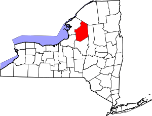 | |
| Villages | ||
| Other hamlets | ||