Corona Municipal Airport
| Corona Municipal Airport | |||||||||||
|---|---|---|---|---|---|---|---|---|---|---|---|
| IATA: none – ICAO: KAJO – FAA LID: AJO | |||||||||||
| Summary | |||||||||||
| Airport type | Public | ||||||||||
| Operator | City of Corona | ||||||||||
| Serves | Corona, Riverside | ||||||||||
| Location | Corona, California | ||||||||||
| Elevation AMSL | 533 ft / 162 m | ||||||||||
| Coordinates | 33°53′52″N 117°36′09″W / 33.89778°N 117.60250°W | ||||||||||
| Website | http://www.discovercorona.com/City-Departments/Public-Works/Corona-Municipal-Airport.aspx | ||||||||||
| Runways | |||||||||||
| |||||||||||
| Statistics (2004) | |||||||||||
| |||||||||||
Corona Municipal Airport (ICAO: KAJO, FAA LID: AJO), formerly L66, is three miles northwest of Corona, serving Riverside County, California.[1] The airport has a few businesses, such as a cafe, "Fly Corona!" flight training center, as well as aircraft maintenance and repair.[2]
Most U.S. airports use the same three-letter location identifier for the FAA and IATA, but Corona Municipal Airport is AJO to the FAA and has no IATA code (Aljouf, Yemen has IATA code AJO).
Facilities
Corona Municipal Airport covers 98 acres (40 ha) and has one asphalt runway, (7/25), 3,200 x 60 ft (975 x 18 m).[1]
In 2004 the airport had 68,000 aircraft operations, average 186 per day, all general aviation. 414 aircraft are based at the airport: 90% single engine, 6% multi-engine, 2% helicopters and 1% ultralight.[1]
Incidents
On January 21, 2008 two private planes collided in Corona killing five people, including one on the ground. The collision occurred about a mile away from the Corona Municipal Airport above Serfas Club Drive. The crash wreckage left debris strewn along a commercial strip near the 91 Freeway. Eyewitnesses claim to see an explosion in the air and two different bodies fall from the sky. The aircraft involved were both single-engine Cessnas, a two-seat Cessna 150 and a four-seat Cessna 172. Investigators from the National Transportation Safety Board, local Corona Police Detectives as well as the Federal Aviation Administration began their probe the following day. As of January 23 a cause for the accident is yet to be determined.
The crash began a debate about the safety of the Corona Municipal Airport as it does not have an operating control tower. The city of Corona has had seven fatal aircraft accidents since 1998.
On July 26, 2008 at approximately 13:47 local time, a baby blue and white 1947 Ercoupe stalled upon takeoff when turning crosswind and crashed into the forest on the southwest side of the airport. Eyewitnesses say that the two elderly pilots had minor injuries, with one of them bleeding from his right cheek where the yoke struck him upon impact. Both are alive, but the airplane is said to have sustained considerable damage.
On November 25, 2012 at approximately 23:00 local time, a Robinson R44 helicopter clipped a refueling station canopy and exploded shortly thereafter. A review of airport video footage showed the helicopter was facing toward the station, lifted off, made a 180-degree turn to the right and tilted forward with its tail coming up immediately prior to the explosion. The solo occupant piloting the aircraft was fatally injured.[3]
References
- 1 2 3 4 FAA Airport Master Record for AJO (Form 5010 PDF), effective 2007-07-05
- ↑ "City of Corona - Businesses at the Corona Airport". City of Corona. Retrieved 4 October 2013.
- ↑ http://latimesblogs.latimes.com/lanow/2012/11/corona-helicopter-crash-pilot-identified-by-coroner.html
External links
- Corona Municipal Airport Official Site at City of Corona web site
- Corona Municipal Airport Pictures and video taken at the Corona Airport
- Resources for this airport:
- FAA airport information for AJO
- AirNav airport information for KAJO
- FlightAware airport information and live flight tracker
- NOAA/NWS latest weather observations
- SkyVector aeronautical chart, Terminal Procedures
Airports in the Inland Empire | ||
|---|---|---|
| Commercial airports | 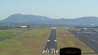 | |
| Towered general aviation airports | ||
| Non-towered general aviation airports | ||
| Military airports | ||