Croft, Leicestershire

Croft is a village of 700 homes in the district of Blaby in Leicestershire, England, off the old Fosse Way and straddling the River Soar. Nearby places include Stoney Stanton, Broughton Astley, Huncote and Narborough. The Hinckley to Leicester railway line runs through the village.
Geography
The village of Croft is about 8 miles (13 km) south west of the City of Leicester in the District of Blaby in Leicestershire. The Civil Parish covers an area of 897 acres (3.63 km2). The population of the civil parish at the 2011 census (including Potters Marston) was 1,639.[1]
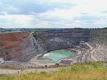
Arbor Road and Broughton Road run from the B4114 (Fosse Way) into the village and Huncote Road runs towards the village of Huncote which lies to the other side of Croft Hill. The village comprises a mix of house types of various ages, factories and shops. The village has a primary school, parish church and public house. Croft Quarry occupies a site at the end of the older part of the village.
Croft Hill stands 128m high rising up the Soar flood-plain, and stands out as an isolated landmark almost at the physical centre of England. The hill provides a number of habitats including broad leaved woodland, scrub land, acidic grassland and two other distinct areas of grassland. It is an important area in view of the variety of flora, fauna, birds and butterflies which inhabit or visit at various times of the year.
The New Hill, to the east of Croft Hill, has been constructed out of quarry waste, and is being landscaped and planted to match the local flora.
Education
- Croft CoE Primary School (ages 5–11)[2]
Children then attend
- Brockington Secondary School & Community College (ages 11–14)
- Lutterworth College (ages 14–18)
Industry & Business
Croft Quarry on Marions Way is the site of several businesses belonging to Aggregate Industries, including Charcon Specialist Products. Aggregate Industries' regional offices are sited in some of the older buildings in the village including Croft House and Greystones.
The village has an industrial area on Winston Avenue with offices and manufacturing companies.
There are also a number of farms, a parade of shops on Pochin Street, and a new office complex, Riverside Court.
Transport
Croft is served by Arriva Fox County Services 50 (Mon - Sat peak) & 50A (Mon - Sat daytime).
Croft Railway Station used to serve the village, but was closed as a result of the Beeching Axe.
Recreation
Croft Cricket Club play at the Recreation Ground, Winston Avenue. Their website[3] has lots of statistics, history and photographs of old and new faces. 2007 was their centenary year. They run two Saturday teams, a Sunday team and junior teams.
Croft F.C. also play at the recreation ground on the adjacent football pitch. A Multi-Use Games Area (MUGA) was built at the Recreation Ground in 2009.
Croft Fun Park was opened in 2002 by Graham Rowntree.
Croft Silver band celebrated its 110th anniversary in 2012.
History
It is local tradition that the parish stone pit at Croft, known as the Clevis, was originally a first-century Roman granite quarry used in the construction of the foundations and bridges of the Fosse Way.[4]
Fenn states that the place-name Croft was first recorded in 836, and is derived from the Old English cræft 'craft, a machine, engine'. The craft in question could perhaps be that of quarrying.[5]
The occasion in 836 was an assembly at Croft when King Wiglaf of Mercia was joined by Archbishop of Canterbury Ceolnoth and eleven of his bishops and three abbots, besides twenty-two laymen of authority and influence. They gathered to witness the grant of land by Wiglaf to the monastery of Hanbury.[6]
It has been suggested that the use of the Croft Hill for Royal Mercian assemblies makes it a candidate location for councils of the Clovesho.[7]
In the 1920s, Croft Hill was used as a picnic spot for Sunday School trips and was popular with Leicester people, it being a short train journey from the surrounding areas.[8]
Notable residents
- The Canadian politician and businessman Charles Avery Dunning (1885-1958) was born in Croft
- The children's novelist Monica Edwards (1912-1998) lived in Croft in 1938-1939
- Laura McLaren, Baroness Aberconway (1854-1933) a suffragist and gardener who improved and expanded Bodnant Garden
- She was the daughter of Henry Davis Pochin (1824–1895), a member of the local quarrying family, and noted industrialist and chemist
- The young people's author, agony aunt & writer on autism Barbara Jacobs lived at Greystones in Croft during the late 1970s
- The controversial writer David Icke (born 1952) lived in Croft for a time in the 1970s
- The mountaineer Simon Yates (1963–present) lived in Croft in his early life
External links
| Wikimedia Commons has media related to Croft, Leicestershire. |
- Croft website on Leicestershirevillages
- Croft Parish Council website
- Croft Players
- Croft - A History
- Aggregate Industries history of Croft Quarry
References
- ↑ "Civil Parish population 2011". National Statistics. Office for National Statistics. Retrieved 10 June 2016.
- ↑ "Home - Croft Church of England Primary School".
- ↑ "Croft Cricket Club : home".
- ↑ Colin Cross, an unpublished history of Croft, 1987
- ↑ http://www.aggregate.com/Documents/Brochures/AboutUs-History-Croft-Quarry-Part1.pdf Quarrying at Croft by RWD Fenn
- ↑ WG Hoskins, 'Croft. Hill', Transactions of the Leicestershire Archaeological Society, Vol 26, 1950,p.84.
- ↑ http://www.leicestershirevillages.com/croft/work-on-early-history-of-croft-b.html Barrie Shore, Alignments of the British Isles, published as Beckhampton Adam
- ↑ http://croft.leicestershireparishcouncils.org/uploads/thecroftdirectory2006.pdf The Croft Directory 2006
Coordinates: 52°33′18″N 1°14′31″W / 52.55491°N 1.24184°W
Towns and villages of Blaby District | ||
|---|---|---|
| Towns |  | |
| Large villages | ||
| Small villages | ||
| Hamlets | ||