Glenfield, Leicestershire
| Glenfield | |
 St Peter's Church, Glenfield |
|
 Glenfield |
|
| Population | 9,643 (parish; 2011 Census) |
|---|---|
| OS grid reference | SK538060 |
| Civil parish | Glenfield |
| District | Blaby |
| Shire county | Leicestershire |
| Region | East Midlands |
| Country | England |
| Sovereign state | United Kingdom |
| Post town | LEICESTER |
| Postcode district | LE3 |
| Dialling code | 0116 |
| Police | Leicestershire |
| Fire | Leicestershire |
| Ambulance | East Midlands |
| EU Parliament | East Midlands |
| UK Parliament | Charnwood |
|
|
Coordinates: 52°38′57″N 1°12′22″W / 52.64907°N 1.20622°W
Glenfield is a village and civil parish in the Blaby district of Leicestershire, England. At the 2011 Census, it had a population of 9,643.[1] Its location at the northwestern fringe of the city of Leicester effectively makes it a suburb, although it is politically and administratively separate. The parish is formally named Glenfields, dating from the merger of the ancient Glenfield parish with Glenfield Frith.
The village is directly to the west of Leicester and is just off junction 21A of the M1 motorway. It is the site of the headquarters of Leicestershire County Council, and of Leicestershire Fire and Rescue Service. It also gives its name to Glenfield Hospital, although the hospital is actually across the city border in Leicester.
The heart of the community is around the Square, with St Peter's Church (CofE), the church hall, the ruins of the former church, and the post office on Church Road, the Methodist Church and Hall and the public library (offering generous Internet access) just inside Station Road, and Park House (parish council), the Memorial Hall, Scout Hut, playground, Glenfield Primary School and the nursery school all located just inside Stamford Street. The Hall County Primary School is located on Glenfield Frith Drive. Situated close to the Hall school is Faire Road commonly known for the row of shops situated there.
History
Glenfield is mentioned in the Domesday Book of 1086, at which time it lay in Guthlaxton hundred and contained 12 households.[2]
The village was greatly enlarged between the 1920s and the 1950s, when the Faire Estate was built. In the 1980s and 1990s another large estate was built on former farm land behind Ellis Park.
Glenfield was the site of the first station from Leicester West Bridge on the Leicester and Swannington Railway, opened on 17 July 1832 as the world's third steam railway. Just before reaching the station the line passed through Glenfield Tunnel, which was built by Robert Stephenson and was, at 1 mile 36 yards, the world's longest railway tunnel at the time. The Glenfield end of the tunnel can still be seen.
Parish facilities

Glenfield has its own village newspaper, The Glenfield Gazette. The parish council own several areas of recreational land, including Ellis Park, Station Park and the Playing Fields. Near to the A50 and the boundary with Groby is the "Millennium Green", which is managed by a local trust. The Gynsills Nature Area can be found at the junction of Gynsill Lane and Stelle Way. A small area of mature trees and a pond, once part of the Gynsills Estate parkland, now an area promoting biodiversity and nature conservation.
The area known as "The Square" was once more of a road and contained many more shops, mostly owned by the Stockley family. These were knocked down in the fifties and sixties to accommodate the roundabout and the maisonettes were built in place of the grocers, post office and butchers shop.
Notable residents
The Australian pioneer and explorer Charles Throsby was born in Glenfield in 1777. Stamford Street was the home of painter Bryan Organ. Salcombe Drive was the home of the pundit Graham Barnfield. Leicester Road was the home of Alderman Bertram Powell Lord Mayor of Leicester 1959-60, from the late 1930s to his death in 1969. The British dramatist and playwright David Campton was a resident of Liberty Road, Glenfield up until his death in 2006. Footballers David Nugent and Chris Wood lived in Glenfield when playing for Leicester City in the mid-2010s.
Shopping
On Station Road there is a large Co-Op superstore with petrol station, Glenfield Kitchens, Morningside Pharmacy, Glenfield Television, and a few other small shops. There are also shops around the Square, Stamford Street and Faire Road. The Square has a butchers shop, S.J.Langton, a rarity in the early 21st century, as the trend is towards the use of large supermarkets.[3] In 2010 Malcome Tuff retired, passing his store on to SJ Langton, where the shop now trades under this name.
Food and drink
There are a variety of pubs, take-away, restaurants and hotels in the Glenfield area. These include the Nag's Head, the Forge (formerly the Griffin), the Gynsills and the Railway Inn (near to the site of the former Glenfield Station). There are Chinese and fish and chip takeaways, and Cypriot and Indian restaurants in the village.
Commercial
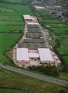
Although Glenfield is mainly residential there are a few businesses located in the area, notably the Widdowson Group link and others located on the Mill Lane Industrial Estate.
Transport
Glenfield is only 3 miles (5 km) away from Leicester, and 1.5 miles (2 km) from the Beaumont Leys Shopping Centre. The M1 can be easily accessed at Junction 21a to the south of the village (southbound only), which makes Fosse Shopping Park accessible. The M1 North can be reached in minutes along the A50 towards Markfield, Groby and Coalville.
The A46 leads around the north of Leicester, with access to Anstey and then the A6 to Loughborough.
The village is served by a number of buses including First Leicester and Centrebus.
Glenfield was once served by the Glenfield railway station with trains into Leicester West Bridge railway station.
References
- ↑ "Key Figures for 2011 Census: Glenfields". Office for National Statistics (Neighbourhood Statistics). Retrieved 29 August 2015.
- ↑ "Place: Glenfield". Open Domesday. Retrieved 29 August 2015.
- ↑ Wallop, Harry (27 December 2007). "Up to 3,000 traditional shops quit high street". The Telegraph. Retrieved 18 February 2012.
External links
![]() Media related to Glenfield, Leicestershire at Wikimedia Commons
Media related to Glenfield, Leicestershire at Wikimedia Commons
Towns and villages of Blaby District | ||
|---|---|---|
| Towns |  | |
| Large villages | ||
| Small villages | ||
| Hamlets | ||