Crooked Tree, Ohio
| Crooked Tree, Ohio | |
|---|---|
| Unincorporated community | |
|
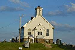
Mary Reed Memorial Methodist Church | |
 Crooked Tree, Ohio | |
| Coordinates: 39°38′16″N 81°29′56″W / 39.63778°N 81.49889°WCoordinates: 39°38′16″N 81°29′56″W / 39.63778°N 81.49889°W | |
| Country | United States |
| State | Ohio |
| County | Noble |
| Elevation | 1,066 ft (325 m) |
| Time zone | Eastern (EST) (UTC-5) |
| • Summer (DST) | EDT (UTC-4) |
| Area code(s) | 740 |
| GNIS feature ID | 1061009[1] |
Crooked Tree is an unincorporated community in Jackson Township, Noble County, Ohio, United States. Crooked Tree is located on Ohio State Route 339, 2 miles (3.2 km) southwest of Dexter City.
History
Crooked Tree was originally called Jacksonville, and under the latter name was laid out in 1854.[2] The present name was given on account of there being a crooked tree near the original town site.[2] A post office was established under the name Crooked Tree in 1858, and remained in operation until 1904.[3]
References
- ↑ "Crooked Tree". Geographic Names Information System. United States Geological Survey.
- 1 2 Martin, Frank M. (1904). The County of Noble: A History of Noble County, Ohio, from the Earliest Days, with Special Chapter on Military Affairs, and Special Attention Given to Resources. Selwyn A. Brant. p. 38.
- ↑ "Noble County". Jim Forte Postal History. Retrieved 7 December 2015.
Municipalities and communities of Noble County, Ohio, United States | ||
|---|---|---|
| Villages |  | |
| Townships | ||
| Unincorporated communities | ||
This article is issued from Wikipedia - version of the 10/27/2016. The text is available under the Creative Commons Attribution/Share Alike but additional terms may apply for the media files.