Cudjoe Key, Florida
| Cudjoe Key, Florida | |
|---|---|
| Census-designated place (CDP) & Unincorporated community | |
 Location in Monroe County and the state of Florida | |
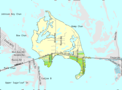 U.S. Census Bureau map showing CDP boundaries | |
| Coordinates: 24°39′51″N 81°28′56″W / 24.66417°N 81.48222°WCoordinates: 24°39′51″N 81°28′56″W / 24.66417°N 81.48222°W | |
| Country |
|
| State |
|
| County | Monroe |
| Area | |
| • Total | 5.6 sq mi (14.6 km2) |
| • Land | 5.2 sq mi (13.6 km2) |
| • Water | 0.4 sq mi (1 km2) |
| Elevation | 0 ft (0 m) |
| Population (2000) | |
| • Total | 1,695 |
| • Density | 302.7/sq mi (116.1/km2) |
| Time zone | Eastern (EST) (UTC-5) |
| • Summer (DST) | EDT (UTC-4) |
| ZIP code | 33042 |
| Area code(s) | 305 |
| FIPS code | 12-15862[1] |
| GNIS feature ID | 1867131[2] |
Cudjoe Key is a census-designated place and unincorporated community in Monroe County, Florida, United States on an island of the same name in the lower Florida Keys. As of the 2000 census, the CDP had a total population of 1,695.
It was originally called Littleton Island.
The United States Army activated Cudjoe Key Air Force Station in 1959 to track missiles traveling through the Eglin Gulf Test Range. The Air Force took over operations the following year,[3] and it subsequently became a detached installation of Homestead Joint Air Reserve Base.[4] The station flies a white radar aerostat, known locally as "Fat Albert", which is used for drug interdiction missions by the Drug Enforcement Administration. On April 20, 2007 a Cessna 182 crashed after its left wing struck the tether anchoring "Fat Albert" . The aerostat is marked on air navigation charts inside a restricted area that contains the warning, "Caution: Unmarked balloon on cable to 14,000 [feet]."
Cudjoe Key may be named after the Joewood tree (Jacquinia keyensis), a native species which is also known as cudjoewood, though a more likely derivation for the name is offered by writer John Viele of Summerland Key. He believes that Cudjoe, a very common Akan name, was the name of a fugitive slave or free negro who lived on the island at some point prior to Gerdes' survey in 1849.[5]
Geography
Cudjoe Key is located at 24°39′51″N 81°28′56″W / 24.66417°N 81.48222°W (24.664298, -81.482339).[6]
U.S. 1 (or the Overseas Highway) crosses the key at approximately mile markers 20.5 – 23, between Summerland and Sugarloaf Keys.
According to the United States Census Bureau, the CDP has a total area of 14.6 km2 (5.6 mi2), of which 13.6 km2 (5.2 mi2) is land and 1.0 km2 (0.4 mi2) (6.93%) is water.
Demographics
As of the census[1] of 2000, there were 1,695 people, 799 households, and 541 families residing in the CDP. The population density was 124.9/km2 (323.6/mi2). There were 1,482 housing units at an average density of 109.2/km2 (282.9/mi2). The racial makeup of the CDP was 96.22% White, 0.88% African American, 0.47% Native American, 0.88% Asian, 0.12% Pacific Islander, 0.71% from other races, and 0.71% from two or more races. Hispanic or Latino of any race were 5.66% of the population.
There were 799 households out of which 15.6% had children under the age of 18 living with them, 62.0% were married couples living together, 3.4% had a female householder with no husband present, and 32.2% were non-families. 21.7% of all households were made up of individuals and 7.8% had someone living alone who was 65 years of age or older. The average household size was 2.12 and the average family size was 2.43.
In the CDP the population was spread out with 12.2% under the age of 18, 3.7% from 18 to 24, 27.1% from 25 to 44, 38.8% from 45 to 64, and 18.2% who were 65 years of age or older. The median age was 48 years. For every 100 females there were 108.2 males. For every 100 females age 18 and over, there were 109.4 males.
The median income for a household in the CDP was $57,500, and the median income for a family was $59,883. Males had a median income of $36,094 versus $31,250 for females. The per capita income for the CDP was $27,085. About 4.4% of families and 5.8% of the population were below the poverty line, including 5.7% of those under age 18 and 5.4% of those age 65 or over.
References
- 1 2 "American FactFinder". United States Census Bureau. Archived from the original on 2013-09-11. Retrieved 2008-01-31.
- ↑ "US Board on Geographic Names". United States Geological Survey. 2007-10-25. Retrieved 2008-01-31.
- ↑ "History of Cudjoe Key AFS, FL". Online Air Defense Radar Museum. Radomes, Inc. Retrieved 2009-12-12.
- ↑ Mueller, Roger (1989). Air Force Bases. Diane Publishing. pp. 253–255. ISBN 978-1-4289-9316-7.
- ↑ "Key Names" Florida Keys Gazetteer Archived July 20, 2008, at the Wayback Machine.
- ↑ "US Gazetteer files: 2010, 2000, and 1990". United States Census Bureau. 2011-02-12. Retrieved 2011-04-23.
Municipalities and communities of Monroe County, Florida, United States | ||
|---|---|---|
| Cities | 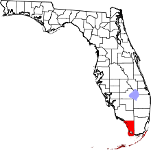 | |
| Village | ||
| CDPs | ||
| Unincorporated communities | ||
| Ghost towns | ||