Islandia, Florida
| Islandia, Florida | |
|---|---|
| Unincorporated Community | |
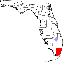
 Location in Miami-Dade County and the state of Florida | |
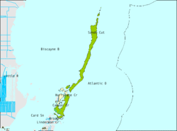 U.S. Census Bureau map showing limits of former city | |
| Coordinates: 25°23′18″N 80°14′10″W / 25.38833°N 80.23611°WCoordinates: 25°23′18″N 80°14′10″W / 25.38833°N 80.23611°W | |
| Country |
|
| State |
|
| County | Miami-Dade |
| Area | |
| • Total | 66.4 sq mi (171.9 km2) |
| • Land | 6.5 sq mi (16.7 km2) |
| • Water | 59.9 sq mi (155.2 km2) |
| Elevation | 3 ft (1 m) |
| Population (2010) | |
| • Total | 18 |
| • Density | 0.27/sq mi (0.10/km2) |
| Time zone | Eastern (EST) (UTC-5) |
| • Summer (DST) | EDT (UTC-4) |
| FIPS code | 12-34175[1] |
| GNIS feature ID | 0304638[2] |
Islandia is a unincorporated community and former city in Miami-Dade County, Florida, United States, located on Elliott Key and other nearby keys, such as Totten Key. The population was 18 at the 2010 Census. Most residents of the city were National Park Service employees.
In the 2010 Primary Election, the Miami-Dade County Commission was empowered via a charter amendment to abolish Islandia. On December 6, 2011, Miami-Dade County Commissioners unanimously approved an ordinance to abolish the city, with final action to be taken after a public hearing.[3][4][5] Following a public hearing, the ordinance abolishing Islandia received final approval on March 6, 2012, and took effect on March 16, 2012.[6][7]
History
Islandia, and in particular Elliott Key, was originally fished by the Native American Tequesta people. It subsequently became a haven for shipwreck survivors. By the mid-1800s, a group of Bahamians had made their way to the key, where they unsuccessfully tried farming on an island with a base of coral rock. By the early 1900s, Islandia had its own school district and more than 100 residents. However, the number of residents dwindled over time due to the lack of electricity, poor farming, and the relatively long distance from the mainland.[8]
In 1950 the Dade County Planning Board announced a plan to build a highway connecting Key Biscayne with the Overseas Highway on Key Largo. The project envisioned a series of bridges connecting artificial islands, to be built on the Safety Valve, and existing small keys to Elliott Key and on to Key Largo. When the Dade County Planning Board was unable to secure a right of way for the highway across the southern end of Key Biscayne, it dropped the plan.[3][9]
At the end of 1960, however, 13 of the island's 18 registered voters approved the incorporation of a municipality, and the 33 northernmost islands of the Florida Keys became the city of Islandia. Developers and the residents revived the plan to build a causeway across the bay, and sought to fill Elliott Key with luxury hotels, golf courses, oceanfront homes, and a six-lane roadway running down the center of the key. A grassroots opposition of fishermen, gardeners, and elected state leaders opposed the plan, and sought to include the islands in the national park system. Islandia mayor Luther Brooks and his small city council fought back, and at one point obtained a large bulldozer and cleared a 125-foot wide swath down the center of Elliott Key as the beginning of the proposed six-lane Elliott Key Boulevard.[8]
Nevertheless, the purchase by the federal government of most of the land on Elliott Key ended those plans, and in 1968, Islandia was made a part of Biscayne National Monument (which later became Biscayne National Park). What remains today of the failed Elliott Key Boulevard is an eight-foot wide nature trail covered by a tree canopy that is mockingly referred to as "Spite Highway."[8]
By 1990, exasperated by decades of the city not filing papers or following municipal procedures, the state of Florida ruled all of Islandia's elections illegal on the grounds that only land owners, as opposed to all residents, had been permitted to vote, in violation of voting-rights laws. The state called for the dismantling of the municipality. In December 2011, the Miami-Dade County Commission finally agreed, and the area reverted to unincorporated status in March 2012 after the Commission gave final approval to the ordinance abolishing the City of Islandia.[6][7][8]
Geography
Islandia is located at 25°23′18″N 80°14′10″W / 25.38833°N 80.23611°W (25.388299, -80.236180).[10]
According to the United States Census Bureau, the city had a total area of 66.4 square miles (172 km2). 6.4 square miles (17 km2) of it is land and 59.9 square miles (155 km2) of it (90.28%) is water.
Surrounding areas
- Biscayne Bay
- Biscayne Bay


 Atlantic Ocean
 - Biscayne Bay

 Atlantic Ocean
 - Key Largo


 Atlantic Ocean
 - Key Largo, Atlantic Ocean
Demographics
2010
As of the census of 2010, there were 18 people, 3 households, and 3 families residing in the city. The population density was 2.7 people per square mile (1.0/km²). There were 3 housing units at an average density of 0.4 persons/mi² (0.2 persons/km²). The racial makeup of the city was 100.0% White (11.1% Non-Hispanic White). Hispanic (U.S. Census) or Latino (U.S. Census) of any race were 88.9% of the population (44.4% Salvadoran, 38.9% Guatemalan, 5.6% Peruvian[11]).
There are 3 households out of which 2 had children under the age of 18 living with them, 3 had a female householder with no husband present living together. The average household size was 6.00 and the average family size was 5.33.
In the city the population was spread out with 6 under the age of 18, 8 from 25 to 44, 3 from 45 to 64 years, and 1 from 65 years and over. The median age was 31.5 years. For every female there was 0.3 males. For every female of age 18 and over, there were 0.2 males.
The median income for a household in the city was $47,214. The per capita income for the city was $32,064. None of the population was below the poverty line.
2000
As of the census of 2000,[1] there were 6 people, 3 households, and 1 family residing in the city. The population density was 0.9 people per square mile (0.4/km²). There were 5 housing units at an average density of 0.8 persons/mi² (0.3 persons/km²). The racial makeup of the city was 100.00% White.
There are 3 households out of which 1 had children under the age of 18 living with them, 1 was a married couple living together, and 2 were non-families. 2 households were made up of individuals. The average household size was 2.00 and the average family size was 4.00. For every female there was 0.3 males. For every female of age 18 and over, there were 0.2 males.
In the city the population was spread out with 2 under the age of 18, 2 from 25 to 44, and 2 from 45 to 64. The median age was 32 years. For every female there was 1 male. For every woman age 18 and over, there was 1 man.
The median income for a household in the city was $41,875, and the median income for a family was $80,488. Males had a median income of $41,875 versus $0 for females. The per capita income for the city was $27,000. None of the population was below the poverty line.
References
- 1 2 "American FactFinder". United States Census Bureau. Retrieved 2008-01-31.
- ↑ "US Board on Geographic Names". United States Geological Survey. 2007-10-25. Retrieved 2008-01-31.
- 1 2 Bandell, Brian (December 6, 2011). "Miami-Dade moves to abolish city of Islandia". South Florida Business Journal. Retrieved 18 December 2011.
- ↑ "See "Population and Housing Occupancy Status: 2010 - County -- County Subdivision and Place" for Florida". United States Census Bureau, Population Division.
- ↑ http://www.miamiherald.com/2010/08/25/1790925/voters-approve-2-charter-measures.html
- 1 2 Miami-Dade Legislative Item File Number: 112413
- 1 2
- 1 2 3 4 Rabin, Charles (Dec 27, 2011). "Miami-Dade's Islandia, a forgotten city, may soon be just a memory". Miami Herald. Retrieved 2011-12-29.
- ↑ Blank, Joan Gill (1996). Key Biscayne. Sarasota, Florida: Pineapple Press, Inc. pp. 166–171. ISBN 1-56164-096-4.
- ↑ "US Gazetteer files: 2010, 2000, and 1990". United States Census Bureau. 2011-02-12. Retrieved 2011-04-23.
- ↑ "QT-P10 Hispanic or Latino by Type: 2010". Retrieved 31 May 2014.