Cumberland Homesteads
|
Cumberland Homesteads Historic District | |
|
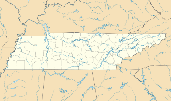
Homesteads Tower | |
  | |
| Location | Roughly along County Seat and Valley Rds., Grassy Cove Rd., Deep Draw and Pigeon Ridge Rds. |
|---|---|
| Nearest city | Crossville, Tennessee |
| Coordinates | 35°54′22″N 84°58′58″W / 35.90611°N 84.98278°WCoordinates: 35°54′22″N 84°58′58″W / 35.90611°N 84.98278°W |
| Area | 10,250 acres (4,150 ha)[1] |
| Built | 1934–1941 |
| Architect | William Macy Stanton[1] |
| Architectural style | FSA small house |
| NRHP Reference # | 88001593[2] |
| Added to NRHP | September 30, 1988 |
Cumberland Homesteads is a community located in Cumberland County, Tennessee, United States. Established by the New Deal-era Division of Subsistence Homesteads in 1934, the community was envisioned by federal planners as a model of cooperative living for the region's distressed farmers, coal miners, and factory workers. While the cooperative experiment failed and the federal government withdrew from the project in the 1940s, the Homesteads community nevertheless survived. In 1988, several hundred of the community's original houses and other buildings, which are characterized by the native "crab orchard" sandstone used in their construction, were added to the National Register of Historic Places as a historic district.[3]
By the early 1930s, decades of poor farming practices had rendered many of the small farms in East Tennessee untenable, and the Great Depression had left thousands of coal miners and other industrial workers unemployed. In January 1934, the Division of Subsistence Homesteads chose Cumberland County as a site for one of its "stranded" agricultural communities, in which families were resettled on small farms and would work in community-owned businesses. Most of the cooperative ventures failed, however, and after World War II the government divested itself of the project. The community's general layout still appears much as it did in the late 1930s.[3]
Location
Cumberland Homesteads is located in a hilly area atop the Cumberland Plateau, just south of Crossville. Byrd Creek, a tributary of the Obed River, flows through and drains much of the community. Cumberland Mountain State Park, which was developed simultaneously in the 1930s as a recreational area, is located in Cumberland Homesteads.
U.S. Route 127 connects the Homestead area with Crossville and I-40 to the north and the Sequatchie Valley to the south. State Highway 68 (Grassy Cove Road) connects the area to Grassy Cove and Spring City to the east. The Cumberland Homesteads Historic District, which covers over 10,000 acres (40 km2), includes properties on Chestnut Lane, Coon Hollow Lane, County Seat Road, Crab Apple Lane, Crab Orchard Road, Deep Draw Road, Grassy Cove Road (TN-68), Highland Lane, Huckleberry Road, Old Mail Road, Open Range Road, Pigeon Ridge Road (TN-419), Saw Mill Road, Turkey Oak Road, and Valley Road, as well as over a dozen structures in Cumberland Mountain State Park.[1]
History
The passage of the National Industrial Recovery Act in 1933 created the Division of Subsistence Homesteads and gave the Roosevelt Administration $25,000,000 to purchase land for the creation of small farming communities for the nation's displaced workers. The Division focused on three types of settlements— communities of part-time farmers near wage-earning employment, communities of farmers resettled from unproductive land, and communities of "stranded" industrial workers, namely miners and loggers. The latter type, which eventually included Cumberland Homesteads, drew the most criticism, as many believed such communities would never be self-supporting.[1]
Cumberland County farm agent Robert Lyons led a local committee that drew up a proposal for a homestead community, which it submitted to the Division of Subsistence Hometeads in December 1933. Lyons had likely been influenced by earlier Plateau-area "back to the land" experiments, such as the Clifty Consolidated Coal Company's 1917 program that helped Fentress County miners purchase small farms,[4] as well as relief efforts provided by local Quakers.[5] Due in part to the influence of Tennessee Valley Authority chairman and cooperative living proponent Arthur Morgan, the Division of Subsistence Homesteads accepted the Cumberland County proposal in January 1934. Over 20,000 acres (81 km2) of land south of Crossville were purchased from the Missouri Land Company, and Cumberland Homesteads, Inc., was created to administer the project.[4]
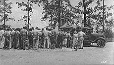
The Civil Works Administration immediately hired several hundred locals to prepare the newly acquired land, providing wages that effectively ended the Great Depression in Cumberland County. Of the initial 233 families selected for the Cumberland Homesteads project, 30% were distressed farmers, 30% were unemployed miners, 30% were unemployed textile workers, and 10% were struggling professionals (including teachers, nurses, and a doctor).[6] Tennessee Valley Authority (TVA) architect William Macy Stanton, who designed a number of buildings in TVA's planned city of Norris, drew up basic designs for houses and other buildings at the Homesteads.[5] The Civilian Conservation Corps built recreational buildings and a small lake for the community at what is now Cumberland Mountain State Park. By late 1934, the community's first stone houses had been completed.[7]
A community-owned store (the "Trading Post") and cannery were established in 1934, but both struggled with inexperienced management. Wage-paying industries never relocated to the Homesteads as the government had hoped, and attempts by homesteaders to establish a coal mine and sorghum mill failed. Throughout the 1930s, the Homesteads project was overseen by a succession of agencies with differing philosophies, leaving the project without a clear purpose. By 1945, the federal government had extricated itself from the Homesteads project after allowing the remaining homesteaders to purchase their farms. Although the original purpose of the Homesteads project failed, the community survived, and over half the farms remained in the hands of original homesteaders through the 1950s.[8]
Building designs
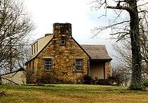
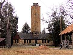
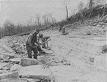
Buildings at Cumberland Homesteads were constructed using primarily a locally-quarried sandstone known as "crab orchard" stone, which is known for its durability and reddish hue in late afternoon sunlight. The most notable building in Cumberland Homesteads is the Homesteads Tower, a cross-shaped building centered around an eight-story octagonal water tower. This building originally housed the Homesteads offices, and is now home to the Homesteads Tower Museum. The elementary school and high school, located behind the Homesteads Tower, consist of unique pod-style designs, with detached classrooms and workshops connected by covered walkways. Both school complexes are now part of Homestead Elementary School. The cannery and hosiery mill have both been modified to the extent that they are not considered contributing properties to the historic district, although their respective water towers are considered contributing structures.[1]
Most of the original 251 houses are still standing. Fifteen distinct housing designs have been identified, with eleven of the designs found multiple times, as they followed basic patterns provided by William Macy Stanton. Stanton's designs include rectangular houses, L-shaped houses, and T-shaped houses, most of which are 1.5 stories with gable roofs and one or two chimneys. Most houses originally had covered-porch entrances and batten doors.[1] Typical interiors consisted of pine paneling with built-in bookcases. Attics contained water storage tanks, and most houses were wired in anticipation of TVA providing electrical power.[7] Most farmsteads included a barn (with either gable or gambrel-roof design), a smokehouse, a chicken house, and toolsheds.[1]
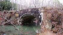
The Cumberland Homesteads Historic District includes several structures at Cumberland Mountain State Park, including Byrd Creek Dam, Millhouse Lodge (originally a gristmill designed by Quakers), several rustic cabins, and a stone water tower. Byrd Creek Dam is the largest masonry structure ever built by the Civilian Conservation Corps.[9] Two stone arch bridges, one along Deep Draw Road and one along Old Mail Road, are listed as contributing structures within the district.[1]
References
- 1 2 3 4 5 6 7 8 Elizabeth Straw, National Register of Historic Places Nomination Form for Cumberland Homesteads Historic District, May 1988.
- ↑ National Park Service (2010-07-09). "National Register Information System". National Register of Historic Places. National Park Service.
- 1 2 Elizabeth Straw, Cumberland Homesteads. Tennessee Encyclopedia of History and Culture, 2002. Retrieved: 30 March 2010.
- 1 2 James Collins Moore, An Analysis of the New Deal Subsistence Homesteads Program in Cumberland County, Tennessee: A Thesis Presented to the Faculty of the Graduate School, Tennessee Technological University (Cookeville, Tenn.: 1967), pp. 1-5.
- 1 2 Edna Gossage Blue, "The Man Stanton," Looking Back: Cumberland Homesteads Golden Anniversary Album (Crossville, Tenn.: E.J.P. Vaden, 1984), p. 6.
- ↑ Moore, thesis, pp. 6-9.
- 1 2 Emma Jean Pedigo Vaden, Looking Back: Cumberland Homesteads Golden Anniversary Album (Crossville, Tenn.: E.J.P. Vaden, 1984), pp. 11-19.
- ↑ Moore, thesis, pp. 13-26.
- ↑ Carroll Van West, Cumberland Mountain State Park. Tennessee Encyclopedia of History and Culture, 2002. Retrieved: 1 April 2010.
External links
| Wikimedia Commons has media related to Cumberland Homesteads. |