Curtis Island National Park
| Curtis Island National Park Queensland | |
|---|---|
|
IUCN category II (national park) | |
 Curtis Island | |
 Curtis Island National Park | |
| Coordinates | 23°31′49″S 151°13′16″E / 23.53028°S 151.22111°ECoordinates: 23°31′49″S 151°13′16″E / 23.53028°S 151.22111°E |
| Established | 1909 |
| Area | 15.5 km2 (6.0 sq mi) |
| Managing authorities | Queensland Parks and Wildlife Service |
| Website | Curtis Island National Park |
| See also | Protected areas of Queensland |
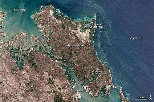
Curtis Island is an island that contains Curtis Island National Park. It is in Queensland, Australia, 474 kilometres northwest of Brisbane and 40 km southeast of Rockhampton.
The island features coastal heaths, littoral rainforest, sand dunes and beach ridges and salt flats.[1] The national park encompasses the Cape Capricorn headland.
No facilities are provided for campers. Bush camping is permitted in three camp grounds.
Southern parts of the island are being heavily developed for multiple coal seam gas export facilities including natural gas liquefaction plants.[2][3]
Heritage listings
Curtis Island has a number of heritage-listed sites, including:
- Sea Hill Point: Sea Hill Light[4]
See also
References
- ↑ "About Curtis Island". Department of National Parks, Recreation, Sport and Racing. 9 December 2010. Retrieved 10 July 2013.
- ↑ "The Queensland Curtis LNG Project". QGC. Retrieved 7 November 2011.
- ↑ "GLNG". 1 November 2011. Retrieved 7 November 2011.
- ↑ "Little Sea Hill Lighthouse (entry 602784)". Queensland Heritage Register. Queensland Heritage Council. Retrieved 11 July 2015.
This article is issued from Wikipedia - version of the 8/1/2016. The text is available under the Creative Commons Attribution/Share Alike but additional terms may apply for the media files.