Civitella di Romagna
| Civitella di Romagna | ||
|---|---|---|
| Comune | ||
| Comune di Civitella di Romagna | ||
 | ||
| ||
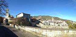
 Civitella di Romagna Location of Civitella di Romagna in Italy | ||
| Coordinates: 44°0′N 11°56′E / 44.000°N 11.933°ECoordinates: 44°0′N 11°56′E / 44.000°N 11.933°E | ||
| Country | Italy | |
| Region | Emilia-Romagna | |
| Province / Metropolitan city | forlì-Cesena (FC) | |
| Frazioni | Castagnolo, Cigno, Civorio, Collina, Cusercoli, Giaggiolo, Nespoli, Petrella, San Paolo, Seggio, Seguno, Voltre | |
| Government | ||
| • Mayor | Pierangelo Bergamaschi | |
| Area | ||
| • Total | 117.8 km2 (45.5 sq mi) | |
| Elevation | 219 m (719 ft) | |
| Population (31 May 2007[1]) | ||
| • Total | 3,790 | |
| • Density | 32/km2 (83/sq mi) | |
| Time zone | CET (UTC+1) | |
| • Summer (DST) | CEST (UTC+2) | |
| Postal code | 47012 | |
| Dialing code | 0543 | |
| Website | Official website | |

Civitella di Romagna is a comune (municipality) in the Province of Forlì-Cesena in the Italian region Emilia-Romagna, located about 70 kilometres (43 mi) southeast of Bologna and about 30 kilometres (19 mi) southwest of Forlì.
Civitella di Romagna borders the following municipalities: Cesena, Galeata, Meldola, Predappio, Santa Sofia, Sarsina.
References
External links
This article is issued from Wikipedia - version of the 11/8/2015. The text is available under the Creative Commons Attribution/Share Alike but additional terms may apply for the media files.