Dahme, Brandenburg
| Dahme | ||
|---|---|---|
|
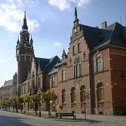
Town hall and post office | ||
| ||
 Dahme | ||
Location of Dahme within Teltow-Fläming district  | ||
| Coordinates: 51°52′00″N 13°25′59″E / 51.86667°N 13.43306°ECoordinates: 51°52′00″N 13°25′59″E / 51.86667°N 13.43306°E | ||
| Country | Germany | |
| State | Brandenburg | |
| District | Teltow-Fläming | |
| Municipal assoc. | Dahme/Mark | |
| Government | ||
| • Mayor | Thomas Willweber (FW) | |
| Area | ||
| • Total | 162.02 km2 (62.56 sq mi) | |
| Population (2015-12-31)[1] | ||
| • Total | 5,073 | |
| • Density | 31/km2 (81/sq mi) | |
| Time zone | CET/CEST (UTC+1/+2) | |
| Postal codes | 15936 | |
| Dialling codes | 035451 | |
| Vehicle registration | TF | |
| Website | www.dahme.de | |
.png)
Dahme (also: Dahme/Mark) is a town in the Teltow-Fläming district of Brandenburg, Germany. It is situated on the Dahme River, 30 km southeast of Luckenwalde, and 38 km west of Lübbenau.
Demography
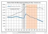 Development of Population since 1875 within the Current Boundaries (Blue Line: Population; Dotted Line: Comparison to Population Development of Brandenburg state)
 Recent Population Development (Blue Line) and Forecasts
|
|
|
|
Notable People
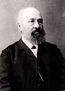
Hermann Hellriegel
- Karsten Greve (born 1946), an internationally renowned art dealer.
- Johannes Groenland (1824-1891), botanist and microscopist who worked for Vilmorin and was a professor of natural science in Dahme.
- Hermann Hellriegel (1831-1895), first head of the agricultural test station in Dahme from 1857 to 1873
- Max Jacob (1849-1921), architect
- Roswitha Krause (born 1949), swimmer and handball player
- Günther Marks (1897-1978), church musician and composer; lecturer for organ play and church music at the evangelical seminar in Dahme
- Otto Unverdorben (1806-1873), discoverer of the Aniline
- Birgit Vanderbeke (born 1956), writer
References
- ↑ "Bevölkerung im Land Brandenburg nach amtsfreien Gemeinden, Ämtern und Gemeinden 31. Dezember 2015 (Fortgeschriebene amtliche Einwohnerzahlen auf Grundlage des Zensus 2011)". Amt für Statistik Berlin-Brandenburg (in German). 2016.
- ↑ Detailed data sources are to be found in the Wikimedia Commons.Population Projection Brandenburg at Wikimedia Commons
| Wikimedia Commons has media related to Dahme/Mark. |
Towns and municipalities in Teltow-Fläming | ||
|---|---|---|
This article is issued from Wikipedia - version of the 10/13/2016. The text is available under the Creative Commons Attribution/Share Alike but additional terms may apply for the media files.