Datil, New Mexico
| Datil, New Mexico | |
|---|---|
| Census-designated place | |
|
Datil viewed from the west | |
 Datil Location within the state of New Mexico | |
| Coordinates: 34°08′40″N 107°50′39″W / 34.14444°N 107.84417°WCoordinates: 34°08′40″N 107°50′39″W / 34.14444°N 107.84417°W[1] | |
| Country | United States |
| State | New Mexico |
| County | Catron |
| Area | |
| • Total | 1.87 sq mi (4.85 km2) |
| • Land | 1.87 sq mi (4.84 km2) |
| • Water | 0.004 sq mi (0.01 km2) |
| Elevation | 7,400 ft (2,300 m) |
| Population (2010) | |
| • Total | 54[2] |
| • Density | 29/sq mi (11.2/km2) |
| Time zone | Mountain (MST) (UTC-5) |
| • Summer (DST) | MDT (UTC) |
| Area code(s) | 575 |
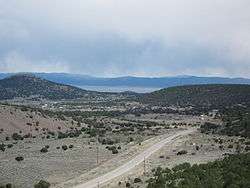
Datil is a census-designated place in Catron County, New Mexico, United States. As of the 2010 census it had a population of 54.[3] Located at the intersection of U.S. Route 60 and New Mexico State Road 12, Datil is on the edge of the Cibola National Forest. The Very Large Array is also nearby. Rock climbers are attracted to Datil because it holds the Enchanted Tower, a climbing hotspot.
History
Datil is named after the nearby Datil Mountains. The name of the mountains came in turn from the Spanish word dátil, meaning “date”; the name most likely resulted from the fruit-like appearance of the seedpods of local yucca species.[4]
The town lay along the Magdalena Stock Driveway.[5] The driveway, which had wells spaced every ten miles along its length, was used by ranchers during the late 19th to mid-20th century as they drove cattle from Springerville, Arizona to the railroad at Magdalena.[6] The Bureau of Land Management maintains a campsite, Datil Well Campground, at the site of one of the former wells. [7]
Geography
Datil is located at the intersection of U.S. Route 60 and New Mexico State Road 12. To the east lie the San Agustin Plains, the Very Large Array, and the village of Magdalena.
To the southwest, several populated subdivisions are accessible from State Road 12. The state highway continues past the local landmark Horse Mountain, a 9490‐foot peak,[8] and further through the small town Apache Creek until reaching the county seat of Reserve.
U.S. 60 travels westward from Datil, passing northwest through the Cibola National Forest and coming out the other side just outside Pie Town, New Mexico.
-
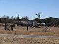
Buildings
-

Church of the Nativity of the Blessed Virgin Mary
Climate
| Climate data for Datil, New Mexico. (1905-1951) | |||||||||||||
|---|---|---|---|---|---|---|---|---|---|---|---|---|---|
| Month | Jan | Feb | Mar | Apr | May | Jun | Jul | Aug | Sep | Oct | Nov | Dec | Year |
| Record high °F (°C) | 68 (20) |
68 (20) |
74 (23) |
86 (30) |
92 (33) |
95 (35) |
98 (37) |
99 (37) |
96 (36) |
86 (30) |
79 (26) |
71 (22) |
99 (37) |
| Average high °F (°C) | 44.7 (7.1) |
49.1 (9.5) |
57.1 (13.9) |
63.7 (17.6) |
72.0 (22.2) |
82.7 (28.2) |
83.1 (28.4) |
81.9 (27.7) |
79.2 (26.2) |
68.7 (20.4) |
56.9 (13.8) |
46.7 (8.2) |
65.5 (18.6) |
| Average low °F (°C) | 10.9 (−11.7) |
17.8 (−7.9) |
21.5 (−5.8) |
28.6 (−1.9) |
32.0 (0) |
41.4 (5.2) |
50.2 (10.1) |
49.5 (9.7) |
40.1 (4.5) |
30.1 (−1.1) |
18.3 (−7.6) |
12.1 (−11.1) |
29.4 (−1.4) |
| Record low °F (°C) | −26 (−32) |
−21 (−29) |
−8 (−22) |
5 (−15) |
11 (−12) |
23 (−5) |
31 (−1) |
33 (1) |
24 (−4) |
9 (−13) |
−10 (−23) |
−18 (−28) |
−26 (−32) |
| Average precipitation inches (mm) | 0.55 (14) |
0.50 (12.7) |
0.44 (11.2) |
0.53 (13.5) |
0.70 (17.8) |
0.74 (18.8) |
2.30 (58.4) |
2.77 (70.4) |
1.72 (43.7) |
0.85 (21.6) |
0.61 (15.5) |
0.70 (17.8) |
12.42 (315.5) |
| Average snowfall inches (cm) | 3.6 (9.1) |
8.8 (22.4) |
3.0 (7.6) |
3.0 (7.6) |
0.6 (1.5) |
0.0 (0) |
0.0 (0) |
0.0 (0) |
0.0 (0) |
0.3 (0.8) |
2.3 (5.8) |
10.0 (25.4) |
31.6 (80.3) |
| Source: The Western Regional Climate Center[9] | |||||||||||||
External links
See also
- Datil Mountains, the namesake of the town.
References
- ↑ U.S. Geological Survey Geographic Names Information System: Datil, New Mexico
- ↑ http://factfinder2.census.gov/faces/tableservices/jsf/pages/productview.xhtml?pid=DEC_10_DP_DPDP1&prodType=table
- ↑ "Geographic Identifiers: 2010 Demographic Profile Data (G001): Datil CDP, New Mexico". U.S. Census Bureau, American Factfinder. Retrieved October 16, 2014.
- ↑ Julyan, Robert (1998). The Place Names of New Mexico. University of New Mexico Press. ISBN 0826316891.
- ↑ "Datil Well Brochure" (PDF). Bureau of Land Management. Retrieved March 21, 2016.
- ↑ "Hit the Old Magdalena Trail". Bureau of Land Management. Retrieved March 21, 2016.
- ↑ "Datil Well Campground". Bureau of Land Management. Retrieved March 21, 2016.
- ↑ "Horse Mountain WSA". Bureau of Land Management. Retrieved March 21, 2016.
- ↑ "Seasonal Temperature and Precipitation Information". Western Regional Climate Center. Retrieved December 15, 2014.
Municipalities and communities of Catron County, New Mexico, United States | ||
|---|---|---|
| Village | 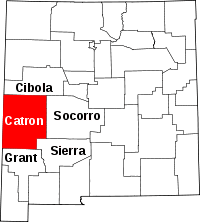 | |
| CDPs | ||
| Other unincorporated communities | ||
| Ghost towns |
| |
| Wikimedia Commons has media related to Datil, New Mexico. |