Debila
| Debila اﻟﺪﺑﻴﻠﺔ | |
|---|---|
| Commune and town | |
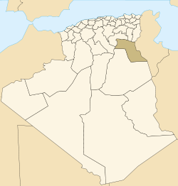
 Location of Debila commune within El Oued Province | |
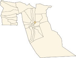
 Debila Location of Debila within Algeria | |
| Coordinates: DZ 33°31′N 6°57′E / 33.517°N 6.950°ECoordinates: DZ 33°31′N 6°57′E / 33.517°N 6.950°E | |
| Country |
|
| Province | El Oued Province |
| District | Debila District |
| Elevation | 58 m (190 ft) |
| Population (2008)[1] | |
| • Total | 25,158 |
| Time zone | CET (UTC+1) |
Debila (Arabic: اﻟﺪﺑﻴﻠﺔ) is a town and commune, and the capital of Debila District, in El Oued Province, Algeria. According to the 2008 census it has a population of 25,158,[1] up from 20,088 in 1998,[2] and an annual growth rate of 2.3%.[1]
Climate
Debila has a hot desert climate (Köppen climate classification BWh), with very hot summers and mild winters. Rainfall is light and sporadic, and summers are particularly dry.
Transportation
Debila lies on the N16 highway, 20 kilometres (12 mi) north of El Oued on the way to Tebessa, and the Tunisian border by the N48. From El Oued the N16 continues to Touggourt, and the N48 leads north towards Biskra.
Education
6.5% of the population has a tertiary education, and another 16.1% has completed secondary education.[3] The overall literacy rate is 74.9%, and is 81.8% among males and 67.8% among females.[4]
Localities
The commune of Debila is composed of six localities:[5]
- Débila
- Akfadou
- Drimini
- Djedeïda
- Chenaïba
- Djamaa Mida
References
- 1 2 3 "Population: El Oued Wilaya" (PDF) (in French). Office National des Statistiques Algérie. Retrieved 12 February 2013.
- ↑ "Algeria Communes". Statoids. Retrieved 9 March 2013.
- ↑ "Structure relative de la population résidente des ménages ordinaires et collectifs âgée de 6 ans et plus selon le niveau d'instruction et la commune de résidence." (PDF) (in French). Office National des Statistiques Algérie. Retrieved 13 February 2013.
- ↑ "Taux d'analphabétisme et taux d'alphabétisation de la population âgée de 15 ans et plus, selon le sexe et la commune de résidence ." (PDF) (in French). Office National des Statistiques Algérie. Retrieved 13 February 2013.
- ↑ "Décret n° 84-365, fixant la composition, la consistance et les limites territoriale des communes. Wilaya d'El Oued" (PDF) (in French). Journal officiel de la République Algérienne. 19 December 1984. p. 1564. Archived from the original (PDF) on 2 March 2013 or before. Retrieved 2 March 2013. Check date values in:
|archive-date=(help) - second listing of "Débila" omitted
 |
Sidi Aoun | Magrane Drimini |
Tébessa Taleb Larbi Hassi Khelifa |
|
| Souihla Guemar |
|
Douar El Ma | ||
| ||||
| | ||||
| Hassani Abdelkrim Kouinine El Oued |
Trifaoui Bayadha |