El Oued
| El Oued اﻟﻮادي | |
|---|---|
| city | |
 | |
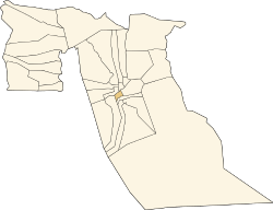 Location of El Oued Commune within El Oued Province | |
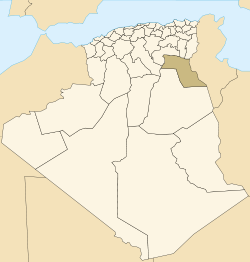
 El Oued Location of El Oued within Algeria | |
| Coordinates: 33°27′20″N 7°11′0″E / 33.45556°N 7.18333°ECoordinates: 33°27′20″N 7°11′0″E / 33.45556°N 7.18333°E | |
| Country |
|
| Province | El Oued Province |
| Province | El Oued District |
| Area | |
| • Total | 77.0 km2 (29.7 sq mi) |
| Elevation | 76 m (249 ft) |
| Population (2008)[1] | |
| • Total | 134,699 |
| • Density | 1,700/km2 (4,500/sq mi) |
| Time zone | CET (UTC+1) |
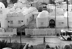
El Oued (Arabic: اﻟﻮادي, meaning the River) or Oued Souf is a city, and the capital of El Oued Province, in Algeria. The oasis town is watered by an underground river, hence its name is El Oued which enables date palm cultivation and the rare use (for the desert) of brick construction for housing. As most roofs are domed, it is known as the "City of a Thousand Domes".[2]
El Oued is located 400 miles (640 km) south east of Algiers (the capital city of Algeria), near the Tunisian border. The population of El Oued was 134,699 as of the 2008 census,[1] up from 105,256 in 1998,[3] with a population growth rate of 2.5%.[1]
History
In 11th, Fatimids send Banu Hilal in Tripolitania, Tunisia and Constantine area against Zirids.
Culture
The inhabitants are also Teroud living in Oued Souf area.
Climate
El Oued has a hot desert climate (Köppen climate classification BWh), with very hot summers and mild winters. Rainfall is light and sporadic, and summers are particularly dry.
| Climate data for El Oued | |||||||||||||
|---|---|---|---|---|---|---|---|---|---|---|---|---|---|
| Month | Jan | Feb | Mar | Apr | May | Jun | Jul | Aug | Sep | Oct | Nov | Dec | Year |
| Record high °C (°F) | 27.6 (81.7) |
35.5 (95.9) |
40.0 (104) |
40.0 (104) |
45.2 (113.4) |
48.6 (119.5) |
49.6 (121.3) |
49.0 (120.2) |
46.0 (114.8) |
41.0 (105.8) |
32.0 (89.6) |
28.2 (82.8) |
49.6 (121.3) |
| Average high °C (°F) | 16.9 (62.4) |
19.6 (67.3) |
22.5 (72.5) |
26.8 (80.2) |
31.7 (89.1) |
37.4 (99.3) |
40.1 (104.2) |
39.8 (103.6) |
34.9 (94.8) |
28.3 (82.9) |
21.8 (71.2) |
17.3 (63.1) |
28.09 (82.55) |
| Daily mean °C (°F) | 11.0 (51.8) |
13.4 (56.1) |
16.1 (61) |
20.1 (68.2) |
24.7 (76.5) |
29.8 (85.6) |
32.5 (90.5) |
32.4 (90.3) |
28.2 (82.8) |
22.0 (71.6) |
15.7 (60.3) |
11.5 (52.7) |
21.45 (70.62) |
| Average low °C (°F) | 5.1 (41.2) |
7.1 (44.8) |
9.6 (49.3) |
13.3 (55.9) |
17.7 (63.9) |
22.2 (72) |
24.7 (76.5) |
24.8 (76.6) |
21.5 (70.7) |
15.6 (60.1) |
9.6 (49.3) |
5.4 (41.7) |
14.72 (58.5) |
| Record low °C (°F) | −2.0 (28.4) |
−2.0 (28.4) |
−5.4 (22.3) |
4.8 (40.6) |
5.0 (41) |
9.0 (48.2) |
17.2 (63) |
14.5 (58.1) |
13.0 (55.4) |
2.1 (35.8) |
0.0 (32) |
−2.2 (28) |
−5.4 (22.3) |
| Average precipitation mm (inches) | 10.7 (0.421) |
9.3 (0.366) |
9.9 (0.39) |
7.0 (0.276) |
5.6 (0.22) |
2.0 (0.079) |
0.1 (0.004) |
1.1 (0.043) |
5.3 (0.209) |
7.8 (0.307) |
9.4 (0.37) |
7.0 (0.276) |
75.2 (2.961) |
| Average relative humidity (%) | 64.7 | 54.1 | 47.0 | 43.7 | 38.1 | 33.2 | 30.4 | 34.6 | 46.5 | 52.9 | 58.8 | 64.8 | 47.4 |
| Source #1: NOAA (1965-1990)[4] | |||||||||||||
| Source #2: climatebase.ru (extremes, humidity)[5] | |||||||||||||
Transportation
The N16 highway connects El Oued to Touggourt to the southwest and Tebessa to the northeast. The N48 connects El Oued to the town of Still to the north, from which the N3 may be used to reach Biskra.
El Oued lies about 20 kilometres (12 mi) south of Guemar Airport.
Education
7.4% of the population has a tertiary education, and another 17.5% has completed secondary education.[6] The overall literacy rate is 86.1% (second highest in the province), and is 91.2% among males (second highest in the province) and 80.6% among females (equal highest in the province).[7]
Localities
The commune of El Oued is composed of six localities:[8]
- El Oued
- Mahda
- Legtouta
- Keraïma
- Oum Sahaouine
- Mih Bahi Sud
References
- 1 2 3 "Population: El Oued Wilaya" (PDF) (in French). Office National des Statistiques Algérie. Retrieved 12 February 2013.
- ↑ "Algeria: El-Oued, the City of a thousand Domes". Algeria Channel. Retrieved 12 February 2013.
- ↑ "Algeria Communes". Statoids. Retrieved 9 March 2013.
- ↑ "Climate Normals for El Oued". Retrieved 12 February 2013.
- ↑ "El Oued, Algeria". Climatebase.ru. Retrieved 12 February 2013.
- ↑ "Structure relative de la population résidente des ménages ordinaires et collectifs âgée de 6 ans et plus selon le niveau d'instruction et la commune de résidence." (PDF) (in French). Office National des Statistiques Algérie. Retrieved 13 February 2013.
- ↑ "Taux d'analphabétisme et taux d'alphabétisation de la population âgée de 15 ans et plus, selon le sexe et la commune de résidence ." (PDF) (in French). Office National des Statistiques Algérie. Retrieved 13 February 2013.
- ↑ "Décret n° 84-365, fixant la composition, la consistance et les limites territoriale des communes. Wilaya d'El Oued" (PDF) (in French). Journal officiel de la République Algérienne. 19 December 1984. p. 1564. Archived from the original (PDF) on 2 March 2013 or before. Retrieved 2 March 2013. Check date values in:
|archive-date=(help)
External links
 |
Biskra El M'Ghair Ourmas |
Sidi Aoun Guemar Kouinine |
Tébessa Hassani Abdelkrim Trifaoui |
|
| Djamaa Touggourt |
|
Douar El Ma | ||
| ||||
| | ||||
| Oum Sahaouine Oued El Alenda Ouargla |
Illizi | Ababsa Sidi Slimane Bayadha Nakhla |
| Wikimedia Commons has media related to El Oued. |