Deer Island, Oregon
| Deer Island, Oregon | |
|---|---|
| Census-designated place | |
|
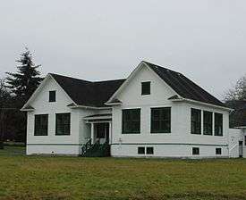
Former Deer Island School | |
 Deer Island  Deer Island | |
| Coordinates: 45°55′52″N 122°50′37″W / 45.93111°N 122.84361°WCoordinates: 45°55′52″N 122°50′37″W / 45.93111°N 122.84361°W | |
| Country | United States |
| State | Oregon |
| County | Columbia |
| Area | |
| • Total | 0.5 sq mi (1.3 km2) |
| • Land | 0.5 sq mi (1.3 km2) |
| • Water | 0 sq mi (0 km2) |
| Elevation | 56 ft (17 m) |
| Population (2010) | |
| • Total | 294 |
| • Density | 602/sq mi (232.6/km2) |
| Time zone | Pacific (PST) (UTC-8) |
| • Summer (DST) | PDT (UTC-7) |
| Area code(s) | 503 & 971 |
| GNIS feature ID | 1136211[1] |
Deer Island is an unincorporated community and census-designated place in Columbia County, Oregon, United States. As of the 2010 census it had a population of 294.[2]
The community is located along U.S. Route 30 north-northwest of Columbia City. Deer Island has a post office with ZIP code 97054.[3]
References
- ↑ "US Board on Geographic Names". United States Geological Survey. 2007-10-25. Retrieved 2008-01-31.
- ↑ "Geographic Identifiers: 2010 Demographic Profile Data (G001): Deer Island CDP, Oregon". U.S. Census Bureau, American Factfinder. Retrieved April 16, 2013.
- ↑ ZIP Code Lookup
Municipalities and communities of Columbia County, Oregon, United States | ||
|---|---|---|
| Cities | 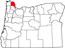 | |
| CDPs | ||
| Other unincorporated communities | ||
This article is issued from Wikipedia - version of the 11/25/2016. The text is available under the Creative Commons Attribution/Share Alike but additional terms may apply for the media files.