Dehtáře
| Dehtáře | |
|---|---|
| Municipality | |
 | |
 Dehtáře | |
| Coordinates: 49°28′56″N 15°16′30″E / 49.48222°N 15.27500°ECoordinates: 49°28′56″N 15°16′30″E / 49.48222°N 15.27500°E | |
| Country |
|
| Region | Vysočina |
| District | Pelhřimov |
| Area | |
| • Total | 7.95 km2 (3.07 sq mi) |
| Elevation | 524 m (1,719 ft) |
| Population (2006) | |
| • Total | 108 |
| • Density | 14/km2 (35/sq mi) |
| Postal code | 393 01 to 394 09 |
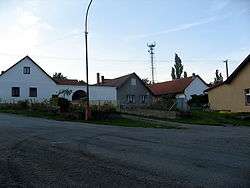
Dehtáře is a village and municipality (obec) in Pelhřimov District in the Vysočina Region of the Czech Republic.
The municipality covers an area of 7.95 square kilometres (3.07 sq mi), and has a population of 108 (as at 2 October 2006).
Dehtáře lies approximately 7 kilometres (4 mi) north-east of Pelhřimov, 25 km (16 mi) north-west of Jihlava, and 91 km (57 mi) south-east of Prague.
References
| Wikimedia Commons has media related to Dehtáře. |
This article is issued from Wikipedia - version of the 9/12/2016. The text is available under the Creative Commons Attribution/Share Alike but additional terms may apply for the media files.