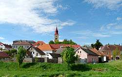
Hořepník
| Hořepník | |
|---|---|
| Municipality | |
 | |
 Hořepník | |
| Coordinates: 49°31′1″N 15°6′3″E / 49.51694°N 15.10083°ECoordinates: 49°31′1″N 15°6′3″E / 49.51694°N 15.10083°E | |
| Country |
|
| Region | Vysočina |
| District | Pelhřimov |
| Area | |
| • Total | 13.62 km2 (5.26 sq mi) |
| Elevation | 457 m (1,499 ft) |
| Population (1.1.2014) | |
| • Total | 623 |
| • Density | 46/km2 (120/sq mi) |
| Postal code | 394 21 |
| Website | http://www.horepnik.cz/ |
Hořepník is a village and municipality (obec) in Pelhřimov District in the Vysočina Region of the Czech Republic.
The municipality covers an area of 13.62 square kilometres (5.26 sq mi), and has a population of 628 (as at 2 October 2006).
Hořepník lies approximately 13 kilometres (8 mi) north-west of Pelhřimov, 38 km (24 mi) west of Jihlava, and 80 km (50 mi) south-east of Prague.
References
| Wikimedia Commons has media related to Hořepník. |
This article is issued from Wikipedia - version of the 4/7/2016. The text is available under the Creative Commons Attribution/Share Alike but additional terms may apply for the media files.