Route 261 (Delaware–Pennsylvania)
| |||||||
|---|---|---|---|---|---|---|---|
| Foulk Road | |||||||
 | |||||||
| Route information | |||||||
| Maintained by DelDOT and PennDOT | |||||||
| Length: |
6.88 mi[1][2] (11.07 km) | ||||||
| Existed: | 1928[3] – present | ||||||
| History: | PA 261 designated in 1928, DE 261 designated by 1938[3][4] | ||||||
| Major junctions | |||||||
| South end: |
| ||||||
|
| |||||||
| North end: |
| ||||||
| Location | |||||||
| Counties: |
DE: New Castle PA: Delaware | ||||||
| Highway system | |||||||
| |||||||


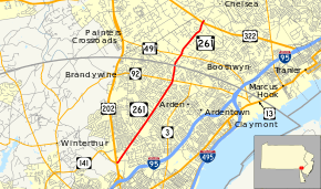
Delaware Route 261 (DE 261) and Pennsylvania Route 261 (PA 261), also known as Foulk Road, is a 6.88-mile (11.07 km) state highway running through Delaware and Pennsylvania. DE 261 runs 4.62 miles (7.44 km) through New Castle County, Delaware from an interchange with U.S. Route 202 (US 202) and DE 141 north of Interstate 95 (I-95) near Fairfax, Delaware, a community north of Wilmington, northeast to the Pennsylvania state line. The road runs through suburban areas of Brandywine Hundred as a four-lane road south of DE 92 and a two-lane road north of DE 92. At the Pennsylvania state line, Foulk Road becomes PA 261 and continues 2.26 miles (3.64 km) through Bethel Township in Delaware County, intersecting PA 491 in Booths Corner before ending at an interchange with US 322.
DE 261 was originally designated along Foulk Road in the 1930s. In the 1960s, most of the route was widened into a four-lane road. The southern terminus at US 202 was reconstructed into an interchange in the 2000s. PA 261 was first designated in 1928 along Foulk Road between the Delaware border and PA 61 and PA 161 in Chelsea. The route was extended north along Valley Brook Road to US 1 in Chester Heights by 1940. The northern terminus of PA 261 was moved to its current location by 1980.
Route description
Delaware

DE 261 begins at an interchange with US 202 and the northern terminus of DE 141 north of Alapocas Run State Park south of Fairfax in Blue Ball, heading northeast on four-lane divided Foulk Road. The road heads near business parks, becoming an undivided road. The route continues through the suburban Brandywine Hundred area, passing residences along with a few businesses. DE 261 remains a four-lane undivided road through this area, occasionally widening into a divided highway at intersections. The route intersects several roads including Murphy Road, Shipley Road, and Silverside Road. Between Shipley and Silverside roads, the road passes to the west of Brandywine High School. Farther northeast, DE 261 comes to the intersection with DE 92 in Ways Corner, at which point it turns north and becomes a two-lane undivided road that passes more homes. The route ends at the Pennsylvania state line.[5][6]
DE 261 has an annual average daily traffic count ranging from a high of 22,555 vehicles at the Silverside Road intersection to a low of 10,414 vehicles at the Pennsylvania border.[1] None of DE 261 is part of the National Highway System.[7]
Pennsylvania
PA 261 begins at the Pennsylvania state line and continues northeast on two-lane undivided Foulk Road through Bethel Township in Delaware County, passing through residential areas as it crosses Zebley Road. In the community of Booths Corner, PA 261 crosses PA 491, at which point the road passes a few businesses. North of this intersection, the road runs between a tank farm to the west and Bethel Springs Elementary School to the east prior to crossing Bethel Road and entering wooded residential neighborhoods. PA 261 ends at an interchange with US 322, with Foulk Road continuing north to an intersection with Concord Road, Chelsea Road, and Valley Brook Road.[6][8]
PA 261 has an annual average daily traffic count ranging from a high of 9,400 vehicles between the Delaware border and PA 491 to a low of 7,200 vehicles between the Bethel Road intersection and US 322.[9] None of PA 261 is part of the National Highway System.[10]
History

Delaware
By 1920, what is now DE 261 existed as a county road.[11] When Delaware first assigned state highway numbers by 1936, what is now DE 261 had been upgraded to a state highway, but did not receive a number at that time.[12] By 1938, DE 261 was designated onto its current alignment between US 202 and the Pennsylvania border, continuing the PA 261 designation.[4] DE 261 was widened into a four-lane road between US 202 and Silverside Road by 1966.[13] The four-lane portion was extended north to Naamans Road a year later.[14] In summer 2007, construction on converting the intersection with US 202 into interchange was completed as part of the Blue Ball Properties project, a project undertaken to improve roads in this area as part of AstraZeneca locating their North American headquarters to the area. DE 141 was also realigned to intersect US 202 and DE 261 at this interchange.[15] The total cost of the project was $123 million.[16]
Pennsylvania
When Pennsylvania first legislated its highways in 1911, what would become PA 261 was legislated as part of Legislative Route 180 between the Delaware border and Chelsea.[17] PA 261 was first designated in 1928 to run from the Delaware border to PA 61 (Concord Road) and PA 161 (Chelsea Road) in Chelsea, following Foulk Road.[3] By 1940, PA 261 was extended north along Valley Brook Road from US 322 (which replaced PA 61) to US 1 in Chester Heights.[18] By 1980, the northern terminus of PA 261 was truncated to its current location at the interchange with US 322.[19]
Major intersections
| State | County | Location | mi[1][2] | km | Destinations | Notes |
|---|---|---|---|---|---|---|
| Delaware | New Castle | Blue Ball | 0.00 | 0.00 | Interchange | |
| Ways Corner | 4.03 | 6.49 | ||||
| Delaware–Pennsylvania state line | 4.62 0.000 | 7.44 0.000 | Northern terminus of DE 261, southern terminus of PA 261 | |||
| Pennsylvania | Delaware | Bethel Township | 0.509 | 0.819 | ||
| 2.260 | 3.637 | Interchange | ||||
| 1.000 mi = 1.609 km; 1.000 km = 0.621 mi | ||||||
See also
 U.S. Roads portal
 Delaware portal
 Pennsylvania portal
References
- 1 2 3 Staff (2011). "Traffic Count and Mileage Report: Interstate, Delaware, and US Routes" (PDF). Delaware Department of Transportation. Retrieved May 17, 2012.
- 1 2 Bureau of Maintenance and Operations (January 2015). Roadway Management System Straight Line Diagrams (Report) (2015 ed.). Pennsylvania Department of Transportation. Retrieved June 30, 2015.
- Delaware County (PDF)
- 1 2 3 Pennsylvania Highway Map (Philadelphia Metro) (Map). Gulf Oil. 1928. Retrieved November 8, 2007.
- 1 2 Delaware State Highway Department; The National Survey Co. (1938). Official Road Map of the State of Delaware (PDF) (Map). Dover: Delaware State Highway Department. Retrieved November 24, 2015.
- ↑ Delaware Department of Transportation (2008). Delaware Official Transportation Map (PDF) (Map). Dover: Delaware Department of Transportation. Retrieved November 24, 2015.
- 1 2 Google (January 15, 2014). "overview of Delaware Route 261 and Pennsylvania Route 261" (Map). Google Maps. Google. Retrieved January 15, 2014.
- ↑ National Highway System: Delaware (PDF) (Map). Federal Highway Administration. 2012. Retrieved January 15, 2014.
- ↑ Delaware County, Pennsylvania Highway Map (PDF) (Map). PennDOT. 2010. Retrieved November 26, 2010.
- ↑ Delaware County, Pennsylvania Traffic Volume Map (PDF) (Map). Pennsylvania Department of Transportation. 2012. Retrieved January 15, 2014.
- ↑ National Highway System: Pennsylvania (PDF) (Map). Federal Highway Administration. 2012. Retrieved January 15, 2014.
- ↑ Delaware State Highway Department (1920). Official Road Map (PDF) (Map). Dover: Delaware State Highway Department. Retrieved November 24, 2015.
- ↑ Delaware State Highway Department; The National Survey Co. (1936). Official Road Map of the State of Delaware (PDF) (Map) (1936–37 ed.). Dover: Delaware State Highway Department. Retrieved November 24, 2015.
- ↑ Delaware State Highway Department (1966). Official Highway Map (PDF) (Map). Dover: Delaware State Highway Department. Retrieved November 24, 2015.
- ↑ Delaware State Highway Department (1967). Official Highway Map (PDF) (Map). Dover: Delaware State Highway Department. Retrieved November 24, 2015.
- ↑ "Blue Ball Properties - Project Elements". Delaware Department of Transportation. Retrieved February 6, 2011.
- ↑ "Blue Ball Properties Project Honored At American Society of Civil Engineers - Delaware Section's Dinner". Delaware Department of Transportation. May 9, 2008. Retrieved January 6, 2011.
- ↑ Map of Pennsylvania Showing State Highways (PDF) (Map). Pennsylvania Department of Highways. 1911. Retrieved January 1, 2014.
- ↑ Official Road Map of Pennsylvania (PDF) (Map). Pennsylvania Department of Highways. 1940. Retrieved January 1, 2014.
- ↑ Pennsylvania Official Transportation Map (PDF) (Map). Pennsylvania Department of Transportation. 1980. Retrieved January 1, 2014.
External links
 Media related to Delaware Route 261 at Wikimedia Commons
- Media related to Pennsylvania Route 261 at Wikimedia Commons